Crevillent
| Crevillent Crevillent | |||
|---|---|---|---|
| Municipality | |||
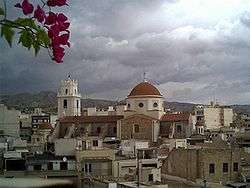 Church of Mare de Déu de Betlem | |||
| |||
 Crevillent Location in Spain | |||
| Coordinates: 38°14′55″N 0°48′32″W / 38.24861°N 0.80889°WCoordinates: 38°14′55″N 0°48′32″W / 38.24861°N 0.80889°W | |||
| Country |
| ||
| Autonomous community |
| ||
| Province | Alicante | ||
| Comarca | Baix Vinalopó | ||
| Judicial district | Elx | ||
| Government | |||
| • Mayor | César Augusto Asencio Adsuar (PP) | ||
| Area | |||
| • Total | 104.50 km2 (40.35 sq mi) | ||
| Elevation | 130 m (430 ft) | ||
| Population (2009) | |||
| • Total | 28,609 | ||
| • Density | 270/km2 (710/sq mi) | ||
| Time zone | UTC+1 (CET) | ||
| • Summer (DST) | UTC+2 (CEST) | ||
| Postal code | 03330 | ||
| Official language(s) | Valencian | ||
| Website | Official website | ||
Crevillent (Valencian pronunciation: [kɾeviˈʎent], Spanish: Crevillente [kɾeβiˈʎente]) is a town and municipality located in the Alicante province, part of the Valencian Community, Spain. It is situated in the comarca of Baix Vinalopó, and lies at the foot of the hill range known locally as Serra de Crevillent. As of 2009, it has a total population of 28,609 inhabitants.
The terrain is dry, and its main vegetation is composed by carob trees, almond trees, olive trees and esparto. Crevillent is a major producer and exporter of carpets and pomegranates.
The town was probably settled by Romans. In 1263, during the period known as Reconquista, James I of Aragon captured the city from the Moors and became a part of the Kingdom of Valencia.
The most important tourist places of the city is a museum with works of Mariano Benlliure, a Valencian sculptor. Also remarkable is its Moros i Cristians festival.
Many of the agricultural areas, particularly El Realengo, contain ruins of prisons, ovens and torture houses used during Francisco Franco's reign and the Spanish Civil War in the early 1900s.
People
- Francisco Mas Magro, Médico y candidato al premio Nobel en 1953
- Cristian López, footballer born 1989
- Juanfran, football player
- Manolo Galván, songwriter
See also
External links
| Wikimedia Commons has media related to Crevillent. |
Municipalities of Baix Vinalopó | ||
|---|---|---|