Crenshaw/LAX Line
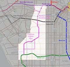 Map of approved route of Crenshaw/LAX Line | ||||||||||||||||||||||||||||||||||||||||||||||||||||||||||||||||||||||||||||||||||||||||||||||||||||||||||||||||||||||||||||||||||||||||||||||||||||||||||||||||||||||||||||||||||||||||||||||||||||||||||||||||||||||||||||||||||||||||||||||||||||||||||||||||||||||||||||||||||||||||||||||||||||||||||||||||||||||||||||||||||||||||||||||||||||||||||||||||||||||||||||||||||||||||||||||||||||||||||||||||||||||||||||||||||||||||||||||||||||||||||||||||||||||||
| Overview | ||||||||||||||||||||||||||||||||||||||||||||||||||||||||||||||||||||||||||||||||||||||||||||||||||||||||||||||||||||||||||||||||||||||||||||||||||||||||||||||||||||||||||||||||||||||||||||||||||||||||||||||||||||||||||||||||||||||||||||||||||||||||||||||||||||||||||||||||||||||||||||||||||||||||||||||||||||||||||||||||||||||||||||||||||||||||||||||||||||||||||||||||||||||||||||||||||||||||||||||||||||||||||||||||||||||||||||||||||||||||||||||||||||||||
| Type | Light rail | |||||||||||||||||||||||||||||||||||||||||||||||||||||||||||||||||||||||||||||||||||||||||||||||||||||||||||||||||||||||||||||||||||||||||||||||||||||||||||||||||||||||||||||||||||||||||||||||||||||||||||||||||||||||||||||||||||||||||||||||||||||||||||||||||||||||||||||||||||||||||||||||||||||||||||||||||||||||||||||||||||||||||||||||||||||||||||||||||||||||||||||||||||||||||||||||||||||||||||||||||||||||||||||||||||||||||||||||||||||||||||||||||||||||
| System | Metro Rail (Los Angeles County) | |||||||||||||||||||||||||||||||||||||||||||||||||||||||||||||||||||||||||||||||||||||||||||||||||||||||||||||||||||||||||||||||||||||||||||||||||||||||||||||||||||||||||||||||||||||||||||||||||||||||||||||||||||||||||||||||||||||||||||||||||||||||||||||||||||||||||||||||||||||||||||||||||||||||||||||||||||||||||||||||||||||||||||||||||||||||||||||||||||||||||||||||||||||||||||||||||||||||||||||||||||||||||||||||||||||||||||||||||||||||||||||||||||||||
| Status | Under construction | |||||||||||||||||||||||||||||||||||||||||||||||||||||||||||||||||||||||||||||||||||||||||||||||||||||||||||||||||||||||||||||||||||||||||||||||||||||||||||||||||||||||||||||||||||||||||||||||||||||||||||||||||||||||||||||||||||||||||||||||||||||||||||||||||||||||||||||||||||||||||||||||||||||||||||||||||||||||||||||||||||||||||||||||||||||||||||||||||||||||||||||||||||||||||||||||||||||||||||||||||||||||||||||||||||||||||||||||||||||||||||||||||||||||
| Locale | Crenshaw, Inglewood, Westchester | |||||||||||||||||||||||||||||||||||||||||||||||||||||||||||||||||||||||||||||||||||||||||||||||||||||||||||||||||||||||||||||||||||||||||||||||||||||||||||||||||||||||||||||||||||||||||||||||||||||||||||||||||||||||||||||||||||||||||||||||||||||||||||||||||||||||||||||||||||||||||||||||||||||||||||||||||||||||||||||||||||||||||||||||||||||||||||||||||||||||||||||||||||||||||||||||||||||||||||||||||||||||||||||||||||||||||||||||||||||||||||||||||||||||
| Termini |
Aviation/Century (south) Expo/Crenshaw (north) | |||||||||||||||||||||||||||||||||||||||||||||||||||||||||||||||||||||||||||||||||||||||||||||||||||||||||||||||||||||||||||||||||||||||||||||||||||||||||||||||||||||||||||||||||||||||||||||||||||||||||||||||||||||||||||||||||||||||||||||||||||||||||||||||||||||||||||||||||||||||||||||||||||||||||||||||||||||||||||||||||||||||||||||||||||||||||||||||||||||||||||||||||||||||||||||||||||||||||||||||||||||||||||||||||||||||||||||||||||||||||||||||||||||||
| Stations | 8[1] (+ 1 under construction infill station) | |||||||||||||||||||||||||||||||||||||||||||||||||||||||||||||||||||||||||||||||||||||||||||||||||||||||||||||||||||||||||||||||||||||||||||||||||||||||||||||||||||||||||||||||||||||||||||||||||||||||||||||||||||||||||||||||||||||||||||||||||||||||||||||||||||||||||||||||||||||||||||||||||||||||||||||||||||||||||||||||||||||||||||||||||||||||||||||||||||||||||||||||||||||||||||||||||||||||||||||||||||||||||||||||||||||||||||||||||||||||||||||||||||||||
| Website | Crenshaw/LAX Transit Project | |||||||||||||||||||||||||||||||||||||||||||||||||||||||||||||||||||||||||||||||||||||||||||||||||||||||||||||||||||||||||||||||||||||||||||||||||||||||||||||||||||||||||||||||||||||||||||||||||||||||||||||||||||||||||||||||||||||||||||||||||||||||||||||||||||||||||||||||||||||||||||||||||||||||||||||||||||||||||||||||||||||||||||||||||||||||||||||||||||||||||||||||||||||||||||||||||||||||||||||||||||||||||||||||||||||||||||||||||||||||||||||||||||||||
| Operation | ||||||||||||||||||||||||||||||||||||||||||||||||||||||||||||||||||||||||||||||||||||||||||||||||||||||||||||||||||||||||||||||||||||||||||||||||||||||||||||||||||||||||||||||||||||||||||||||||||||||||||||||||||||||||||||||||||||||||||||||||||||||||||||||||||||||||||||||||||||||||||||||||||||||||||||||||||||||||||||||||||||||||||||||||||||||||||||||||||||||||||||||||||||||||||||||||||||||||||||||||||||||||||||||||||||||||||||||||||||||||||||||||||||||||
| Opened | Late 2019 (expected)[1] | |||||||||||||||||||||||||||||||||||||||||||||||||||||||||||||||||||||||||||||||||||||||||||||||||||||||||||||||||||||||||||||||||||||||||||||||||||||||||||||||||||||||||||||||||||||||||||||||||||||||||||||||||||||||||||||||||||||||||||||||||||||||||||||||||||||||||||||||||||||||||||||||||||||||||||||||||||||||||||||||||||||||||||||||||||||||||||||||||||||||||||||||||||||||||||||||||||||||||||||||||||||||||||||||||||||||||||||||||||||||||||||||||||||||
| Owner | Metro Rail | |||||||||||||||||||||||||||||||||||||||||||||||||||||||||||||||||||||||||||||||||||||||||||||||||||||||||||||||||||||||||||||||||||||||||||||||||||||||||||||||||||||||||||||||||||||||||||||||||||||||||||||||||||||||||||||||||||||||||||||||||||||||||||||||||||||||||||||||||||||||||||||||||||||||||||||||||||||||||||||||||||||||||||||||||||||||||||||||||||||||||||||||||||||||||||||||||||||||||||||||||||||||||||||||||||||||||||||||||||||||||||||||||||||||
| Operator(s) |
| |||||||||||||||||||||||||||||||||||||||||||||||||||||||||||||||||||||||||||||||||||||||||||||||||||||||||||||||||||||||||||||||||||||||||||||||||||||||||||||||||||||||||||||||||||||||||||||||||||||||||||||||||||||||||||||||||||||||||||||||||||||||||||||||||||||||||||||||||||||||||||||||||||||||||||||||||||||||||||||||||||||||||||||||||||||||||||||||||||||||||||||||||||||||||||||||||||||||||||||||||||||||||||||||||||||||||||||||||||||||||||||||||||||||
| Character | At-grade, underground sections and aerial sections | |||||||||||||||||||||||||||||||||||||||||||||||||||||||||||||||||||||||||||||||||||||||||||||||||||||||||||||||||||||||||||||||||||||||||||||||||||||||||||||||||||||||||||||||||||||||||||||||||||||||||||||||||||||||||||||||||||||||||||||||||||||||||||||||||||||||||||||||||||||||||||||||||||||||||||||||||||||||||||||||||||||||||||||||||||||||||||||||||||||||||||||||||||||||||||||||||||||||||||||||||||||||||||||||||||||||||||||||||||||||||||||||||||||||
| Technical | ||||||||||||||||||||||||||||||||||||||||||||||||||||||||||||||||||||||||||||||||||||||||||||||||||||||||||||||||||||||||||||||||||||||||||||||||||||||||||||||||||||||||||||||||||||||||||||||||||||||||||||||||||||||||||||||||||||||||||||||||||||||||||||||||||||||||||||||||||||||||||||||||||||||||||||||||||||||||||||||||||||||||||||||||||||||||||||||||||||||||||||||||||||||||||||||||||||||||||||||||||||||||||||||||||||||||||||||||||||||||||||||||||||||||
| Line length | 8.5 miles (13.7 km)[1] | |||||||||||||||||||||||||||||||||||||||||||||||||||||||||||||||||||||||||||||||||||||||||||||||||||||||||||||||||||||||||||||||||||||||||||||||||||||||||||||||||||||||||||||||||||||||||||||||||||||||||||||||||||||||||||||||||||||||||||||||||||||||||||||||||||||||||||||||||||||||||||||||||||||||||||||||||||||||||||||||||||||||||||||||||||||||||||||||||||||||||||||||||||||||||||||||||||||||||||||||||||||||||||||||||||||||||||||||||||||||||||||||||||||||
| Track gauge | 4 ft 8 1⁄2 in (1,435 mm) | |||||||||||||||||||||||||||||||||||||||||||||||||||||||||||||||||||||||||||||||||||||||||||||||||||||||||||||||||||||||||||||||||||||||||||||||||||||||||||||||||||||||||||||||||||||||||||||||||||||||||||||||||||||||||||||||||||||||||||||||||||||||||||||||||||||||||||||||||||||||||||||||||||||||||||||||||||||||||||||||||||||||||||||||||||||||||||||||||||||||||||||||||||||||||||||||||||||||||||||||||||||||||||||||||||||||||||||||||||||||||||||||||||||||
| ||||||||||||||||||||||||||||||||||||||||||||||||||||||||||||||||||||||||||||||||||||||||||||||||||||||||||||||||||||||||||||||||||||||||||||||||||||||||||||||||||||||||||||||||||||||||||||||||||||||||||||||||||||||||||||||||||||||||||||||||||||||||||||||||||||||||||||||||||||||||||||||||||||||||||||||||||||||||||||||||||||||||||||||||||||||||||||||||||||||||||||||||||||||||||||||||||||||||||||||||||||||||||||||||||||||||||||||||||||||||||||||||||||||||
The Crenshaw/LAX Line is an under-construction light-rail line that will run through southwest Los Angeles. The line will run generally north-south and will connect the Crenshaw Neighborhood and Leimert Park to the City of Inglewood and Los Angeles International Airport (LAX). When completed, the line will be a part of the Los Angeles County Metro Rail System.
The project is being built by Los Angeles County Metropolitan Transportation Authority (Metro). The project has been given high priority by Metro in its long-range plan,[2] and has funding set aside in Measure R.[3]
The Final EIR was certified on 22 September 2011.[4] FTA approval to build the $1.766 billion[5] light rail line was given in January 2012.[6]
Metro began pre-construction in July 2012, and a Notice To Proceed was issued by Metro in September 2013.[7] An official ground-breaking ceremony for the project was held on January 21, 2014.[8] Heavy construction began in June 2014 and initial revenue service projected to begin by late 2019.[1]
Route
The Metro Crenshaw/LAX Line project is an 8.5-mile light-rail (LRT) route, starting at the Expo/Crenshaw station on the Metro Expo Line, and connecting at a wye to the existing Metro Green Line just to the west of Aviation/LAX station. The initial segment includes eight stations; an infill station, Aviation/96th Street, will be built later to accommodate a planned people mover system at LAX.[9]
The northern half of the route follows Crenshaw Boulevard from Exposition Boulevard down to 67th Street. The southern half of the route utilizes the Harbor Subdivision Right-Of-Way (ROW) from Crenshaw Boulevard to the Green Line just west of Imperial/Aviation.
At its northern terminus, Metro has decided not to directly connect the Crenshaw Line track to the at-grade Metro Expo Line track. Such a connection would have allowed the Crenshaw Line to interline with the Expo Line and terminate in Downtown Los Angeles. However, Metro argues that this is not operationally feasible (three lines would share tracks on Flower Street, leading to delays), and is therefore not worth the cost. Instead, its northern terminus will be an underground subway station at Expo/Crenshaw, built to enable a planned northern extension to the Purple Line and the Hollywood/Highland station on the Red Line in Hollywood.
Station listing
The project will include nine new Metro stations (including an infill station that will not open until several years after the rest of the line):
| Station | Level | Notes |
|---|---|---|
| Expo/Crenshaw[10][8] | underground | Interchange with Expo Line. |
| Martin Luther King Jr[10][8] | underground | |
| Leimert Park[10][8] | underground | |
| Hyde Park[10] | at-grade | |
| Fairview Heights[10] | at-grade | |
| Downtown Inglewood[10] | at-grade | |
| Westchester/Veterans[10] | at-grade | |
| Aviation/96th Street | at-grade | Future connection to LAX people mover (elevated). Scheduled to open in 2021, two years after the rest of the line.[11] |
| Aviation/Century[10] | elevated |
Future service
In June of 2018, Metro staff recommended a service pattern that would see two new services using the newly built infrastructure:
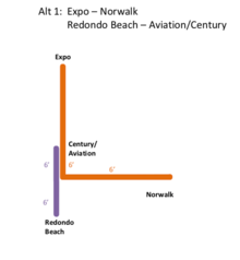
- One service would connect Expo/Crenshaw and Norwalk, running along the newly built line, then turning at the wye, passing through Aviation/LAX and continuing along the existing Green Line.
- Another, shorter, service would connect Redondo Beach and the newly constructed Aviation/Century station, running mostly along the existing southwest section of the Green Line, then passing through the wye after Mariposa to briefly travel along the newly built line. This service would extend to Aviation/96th Street when that station opens.
At peak hours, both services would see 6 minute headways. In addition, when the Crenshaw/LAX line opens in 2019, the current G Shuttle bus connecting Metro Rail to the LAX terminals would shift from Aviation/LAX to the new closer Aviation/Century station, providing a connection for air travelers until the opening of the LAX Train and Aviation/96th in 2023.[12]
The arrangement is meant to provide a seamless rail option for the many passengers who currently transfer between the Green Line and north-south bus lines in the area, as well as operationally combine the Norwalk-LAX and Crenshaw/Expo-LAX legs, which have matching capacity needs, rather than combining either with the more sparsely used Redondo Beach leg. Operating all three potential routes through the wye (Redondo-Expo, Norwalk-Expo, and Norwalk-Redondo) would require increased headways and result in longer trip times, and capacity constraints on the Crenshaw/LAX Line infrastructure ruled out Crenshaw operating as a frequent-service trunk feeding both ends of the current Green Line.
Metro staff stated that operational patterns may change with the future opening of extensions south from Redondo Beach to Torrance or north from Expo/Crenshaw to Hollywood. The full Metro board has yet to approve the proposals,[13] which were met with resistance from some board members, particularly Supervisor Janice Hahn. The board will come to a decision on the routing later in 2018.[14]

Previous proposals had suggested that one line would operate between Expo/Crenshaw station in the north and Aviation/Century in the south, or possibly extend to Redondo Beach station once the stations west of Aviation/LAX station could accommodate 3-car trains, with the strech southwest of the wye also served by the Metro Green Line.[15] An additional service would have connected Norwalk to the new Aviation/Century station and planned 96th Street Transit station and the Airport Metro Connector.[16]
History
The line was planned following the Los Angeles riots of 1992 as a way to better serve transit-dependent residents in the corridor while at the same time providing stimulus for positive economic growth in the South Los Angeles region. It was championed by State Senator Diane Watson and County Supervisor Yvonne Brathwaite Burke, both representing portions of the corridor.
In 1993-94, a Major Investment Study (MIS) was initiated.[1] An architectural design and planning visioning was performed by the USC school of Architecture in 1996. A route refinement study followed in 1999-2000 to improve the shelf life and to narrow down the number of alternatives.
A new Major Investment Study (MIS) was completed in 2003. From 2007 through 2009, Metro conducted a draft environmental review of the line, taking public input and analyzing the environmental impacts and benefits of various alternatives. In December 2009, the Metro Board approved the Draft Environmental Impact Report[17] and chose a "Locally Preferred Alternative".[18]
This alternative, which included the preferred mode and route, became the subject of a final environmental study, resulting in a Final Environmental Impact Report. This final study was completed in May 2011.[19]
Local community leaders, neighborhood councils, L.A. County Supervisors Yvonne Burke and Mark Ridley-Thomas, and Congresswoman Diane Watson continued to express enthusiastic support for the proposed light-rail line. In a letter to Metro dated November 5, 2007, Congresswoman Watson wrote:
Having advocated strenuously for a light rail 'spur line' to carry passengers from the Wilshire Corridor down the Crenshaw Corridor and, ultimately, to LAX for 25 years now, I am delighted to offer continued encouragement, advocacy and feedback for a Metro study (to)…avoid aggravating (the) Leimert Park traffic bottleneck, Coliseum to Vernon;…Wilshire/La Brea station connection to Westside Corridor line, avoiding hydrogen sulfide;…fully consider (the) below-grade option. (Comment ID 116-125 in the cited link)[20]
Environmental review process
The Draft Environmental Impact Report (DEIR) describes several alternatives, as well as "Design Options" (optional features with additional cost).[17] Many other alignments were considered previously, but eliminated due to lack of feasibility or benefit.
The following table summarizes key characteristics of each alternative:
| Name | Cost (millions)* |
Description |
|---|---|---|
| Project Alternatives | ||
| No-Build | $0 | Nothing is built. (This is required for comparison to other alternatives.) |
| TSM | $25 | "Transportation Systems Management": expanded bus service. |
| BRT (Bus Rapid Transit) | $554 | High capacity buses, dedicated bus lanes, 12 bus stations along route between Imperial/Aviation and Wilshire/Western. |
| LRT (Light-Rail Transit) | $1,306 | Light-rail trains, double-track route, 7-8 stations along route between Imperial/Aviation and Exposition/Crenshaw. |
| Design Options (LRT only) | ||
| Design Option 1 | $11 | Adds aerial grade separation at Century/Aviation, station also aerial. |
| Design Option 2 | $16 | Adds aerial grade separation at Manchester/Aviation. |
| Design Option 3 | $13 | Adds cut-and-cover (below-grade) grade separation at ROW/Centinela. |
| Design Option 4 | $29 | Replaces aerial grade-separation between 60th Street and Victoria Avenue with cut-and-cover (below-grade). |
| Design Option 5 | $155 | Adds a below-grade station at Leimert Park (Vernon Avenue). |
| Design Option 6 | $236 | Adds below-grade grade separation between Exposition and 39th Street. |
* in 2008 dollars.
Maintenance facility
Metro staff studied and ranked 16 potential sites for the required maintenance facility.[21] Through several rounds of screening, all but five were eliminated.
In March 2011, a Supplemental DEIS/R was released to the public, specifically related to the maintenance facility. This study was completed due to changes to capacity requirements of the Crenshaw Line. Three of the screened sites were carried forward into this study, and one new site was added.[22] The four site options studied in the Supplemental DEIS/R (from north to south) are:
| Site # | Name | City | Size (acres) | Operation |
|---|---|---|---|---|
| 14 | Arbor Vitae/Bellanca | Westchester | 17.6 | standalone |
| 15 | Manchester/Aviation | Inglewood | 20.5 | standalone |
| 17 | Marine/Redondo Beach | Redondo Beach | 14.2 | satellite to Division 22 |
| D22N | Division 22 Expansion | Hawthorne | 3.5 | satellite to Division 22 |
Following the public comment period in April 2011, staff recommended adoption of the Arbor Vitae/Bellanca site, since it had no public objections and all environmental impacts could be mitigated.[19]
Selected alternative
In December 2009, the Metro Board selected a Locally Preferred Alternative (LPA), and in 2010 Metro conducted the Final Environmental Study for this alternative. This alternative included the LRT Baseline alignment, plus Design Options 1, 2 and 4. At this time, Metro also authorized further study of the remaining design options.
In selecting this alternative, Metro staff eliminated the BRT (bus rapid transit) alternative, stating that it was too slow to provide much benefit, and that it generally lacked public support.
Metro staff also concluded that the northernmost portion of the Crenshaw Corridor between Exposition and Wilshire was too expensive to include in the project if implemented as light-rail. Thus, study and implementation of that segment was deferred, to be considered separately in the future as a northern extension ("Phase 2") of the Crenshaw Line (see section below).
Metro estimated the light-rail line will initially have a daily ridership between 13,000 and 16,000, would cost $1.3 billion - $1.8 billion (in 2008 dollars), would take five years to complete construction, and would generate 7,800 construction jobs over this period.[17]
Grade separations
The route had several segments under consideration for grade-separations. The LRT Baseline (DEIR) included a minimal set of grade separations: the design options specified additional grade separations. The locally preferred alternative (LPA) adopted by the Metro Board included the LRT Baseline plus some additional grade separations (e.g. Design Options 1, 2 and 4). Other grade separations were also still under consideration. All grade separations are subject to the Metro Grade Crossing Policy.[23]
The following table describes the Crenshaw Corridor's route, divided into segments with potential grade-separations:
| Segment Start | Segment End | Length (miles) |
Location | LRT Baseline[17] | Locally Preferred Alternative[18] |
Additional Proposed |
Stations In Segment |
|---|---|---|---|---|---|---|---|
| Crenshaw/Expo (northern terminus) |
Crenshaw/39th (north of King) |
0.5 | street median | at-grade | at-grade | below-grade (DO6) | Exposition |
| Crenshaw/39th (north of King) |
Crenshaw/48th (south of Vernon) |
1.1 | street median | below-grade | below-grade | King, Vernon | |
| Crenshaw/48th (south of Vernon) |
Crenshaw/60th (south of Slauson) |
1.0 | street median | at-grade | at-grade | below-grade (PMH) | Slauson |
| Crenshaw/60th (south of Slauson) |
ROW/Victoria (west of Crenshaw) |
0.6 | street median | aerial | below-grade (DO4) | ||
| ROW/Victoria (west of Crenshaw) |
Florence east of Centinela | 0.9 | ROW | at-grade | at-grade | West | |
| Florence east of Centinela | Florence/Locust (betw. Centinela and La Brea) |
0.4 | ROW crossing Centinela |
at-grade | at-grade | below-grade (DO3) | |
| Florence/Locust (betw. Centinela and La Brea) |
Florence/Eucalyptus (west of La Brea) |
0.6 | ROW crossing La Brea |
aerial | aerial | La Brea | |
| Florence/Eucalyptus (west of La Brea) |
Florence/Hyde Park (east of 405) |
0.6 | ROW | at-grade | at-grade | ||
| Florence/Hyde Park (east of 405) |
Florence west of La Cienega | 0.3 | ROW crossing 405 and La Cienega |
aerial | aerial | ||
| Florence west of La Cienega | Florence/Hindry (north of Manchester) |
0.3 | ROW | at-grade | at-grade | ||
| Florence/Hindry (north of Manchester) |
Aviation south of Manchester | 0.2 | ROW crossing Manchester |
at-grade | aerial (DO2) | Manchester | |
| Aviation south of Manchester | Aviation north of Century | 0.7 | ROW | at-grade | at-grade | ||
| Aviation north of Century | Aviation south of Century | 0.4 | ROW crossing Century |
at-grade | aerial (DO1) | Century | |
| Aviation south of Century | Aviation north of Imperial | 0.7 | ROW | below-grade | below-grade | ||
| Aviation north of Imperial | Aviation/Imperial (southern terminus) |
0.2 | ROW crossing Imperial |
aerial | aerial |
Notes:
- DO1: Design Option 1, $11 million. Approved and in LPA.
- DO2: Design Option 2, $16 million. Approved and in LPA.
- DO3: Design Option 3, $13 million. Studied; ultimately not adopted.
- DO4: Design Option 4, $29 million. Approved and in LPA.
- DO6: Design Option 6, $236 million. Studied; added to project in 2013.
- PMH: Study of grade-separating (underground) the line through Park Mesa Heights between 48th and 60th Streets, requested by County Supervisor Mark Ridley-Thomas. See section below.
Park Mesa Tunnel
In 2010, Supervisor Mark Ridley-Thomas requested study of a tunnel through Park Mesa Heights on Crenshaw Boulevard between 48th and 59th Streets. Metro staff studied the option and recommended against it. Staff concluded the option offers minimal benefit but high cost. The additional cost for the tunnel would be $219 million, or $167 million with Slauson station removed. Instead that section of the line will be at-grade level.[24][25]
Leimert Park and Hindry stations
In May 2011, Supervisor Ridley-Thomas asked the Metro Board to vote on a motion requiring construction of both the tunnel and the subway station in Leimert Park Plaza (Crenshaw/Vernon). The Board voted to include an underground station at Leimert Park and approved the station only under the condition that the entire project can be completed within its original budget.[26]
In May 2013, the Metro Board voted 10-1 to officially include an underground station at Leimert Park (Crenshaw/Vernon, at Crenshaw Blvd and 43rd Place), and another at-grade station at Hindry Ave (Florence/Hindry), in the Crenshaw/LAX Line project.[5]
Aviation/96th station
In 2014, Metro approved the planning and scoping of an infill station at 96th and Aviation, which would connect to the proposed LAX Train automated people mover system to the airport terminals.[11][27] The station would be less than half a mile north of the under construction Aviation/Century station, and would serve as Metro Rail's main gateway to the airport itself, while the Aviation/Century station would serve destinations along the busy Century Boulevard corridor. The proposed station would be served by Green Line trains as well as trains along the new Crenshaw/LAX Line.[28]
Project budget
Measure R assumes a project cost of $1.470 billion (2008 dollars). Measure R sales tax revenues will provide up to $1.207 billion (82% of the budgeted cost). The remaining $263 million is expected to come from local funding. The Crenshaw Corridor project did not seek state or federal funding.[29]
The LPA (including Design Options 1, 2 and 4) was estimated to cost $1.306 billion, which was within budget. If Metro were to include the remaining three design options, the cost would rise to $1.766 billion, exceeding the Measure R project cost by nearly $300 million, requiring cost deferments.
In October 2010 the federal government awarded the corridor a $546 million loan, to be paid back by Measure R tax revenue. The loan allowed pre-construction for the project to begin in summer 2012. The final Crenshaw/LAX Transit Corridor budget was $1.763-billion,[5] as it included most of the design options. Project completion is expected in 2019.[1]
Ultimately, the LPA, with the addition of Design Option 6 and the underground Leimert Park station, is budgeted at $1.766 billion.[5]
Future Extensions
Phase 2 – Crenshaw Northern Extension (To Hollywood)
The original plans for the Crenshaw Corridor project connected Wilshire Blvd to LAX. However, during environmental review, Metro determined that if LRT were selected as the preferred mode, the cost for the entire route would exceed the project budget. In December 2009, the Metro Board selected LRT as the preferred mode; as a result, the part of the corridor north of Exposition Boulevard was deferred until funds become available. This segment can be considered a "Phase 2" extension of the original line.
Any Phase 2 extension would be expected to connect to the Purple Line, the first phase of which is currently under construction as part of the Purple Line Extension project and the Red Line.
In May 2009, Metro released a report on the feasibility of an extension north to Wilshire Boulevard.[30] It first screened two routes—one to Wilshire/La Brea, and another to Wilshire/Crenshaw. Through this screening, staff concluded that Wilshire/La Brea would be more cost-effective and more compatible with land uses and plans along its route. Specifically, the report cited the following advantages of the La Brea route over the Crenshaw route:
- Greater residential and job density,
- Supportive land-uses for a high capacity subway,
- Stronger regional potential to link this corridor northward towards Hollywood in the future,
- Strong community support in the Hancock Park area and
- Fewer geotechnical soil impacts compared to the Hydrogen sulfide soil along Crenshaw Blvd north of Pico Boulevard.
In October 2010, the Metro Board voted to eliminate the Wilshire/Crenshaw station from the Purple Line Subway Extension project, for similar reasons.[31]
The 3.5-mile Wilshire/La Brea route heads north on Crenshaw to Venice, west on Venice to San Vicente, continuing northwest on San Vicente to La Brea, and then north on La Brea to Wilshire. It has three possible stations: Crenshaw/Adams (optional), Pico/San Vicente, and Wilshire/La Brea.
The feasibility report also allowed for two possible branches/extensions along La Brea Ave, Fairfax Ave, La Cienega Blvd or San Vicente Blvd heading north of Wilshire into West Hollywood and/or Hollywood.
In November 2010, Metro staff produced an initial review of the feasibility of studying a new transit corridor to connect the Crenshaw Corridor to West Hollywood and/or Hollywood.[32]
In May 2014, the West Hollywood City Council considered a proposal by Councilmembers John Heilman and Jeffrey Prang to engage a lobbyist to promote the need for Metro rail services in West Hollywood. The Heilman/Prang proposal notes that “former Los Angeles Mayor Antonio Villaraigosa assured West Hollywood representatives that West Hollywood would be ‘next in line’.”[33] In 2015, the West Hollywood City Council launched the West Hollywood Advocates for Metro Rail (WHAM) as part of a campaign to win grassroots support for a Metro rail extension into the city.[34]
In September 2016, in a letter to West Hollywood City Councilmember Lindsey Horvath, Metro CEO Phil Washington outlined several steps Metro is taking to make the Crenshaw/LAX northern extension “shovel ready” should county voters approve Measure M, a countywide ballot measure adding new transit projects and expediting others previously approved under Measure R.[35]
Connection to Phase 1
The final design of "Phase 1" (the original project line south of Exposition Blvd to LAX) would determine how the Phase 2 project could or would connect to Phase 1. The original locally preferred alternative (LPA) for the Crenshaw/LAX Line from the draft environmental impact study (Draft EIS/EIR) specified an at-grade station at the Phase 1 Expo/Crenshaw terminus, with the Leimert Park tunnel ending several blocks south of that, near 39th Street. If Phase 1 had been built per the LPA, then Phase 2 would have require the building of a new tunnel with a connection near 39th Street. This would have required the north end of the Leimert Park tunnel to be outfitted with knockout panels to allow for the possible future extension north.[36]
Metro also studied "Design Option 6" for Phase 1, which would extend the Leimert Park tunnel north to the line's northern terminus at Exposition, with an underground station at Crenshaw/Exposition. This design option was selected so that Phase 2 can connect to Phase 1 directly at the Crenshaw/Exposition station's tunnels. This design option increased the cost of the original Phase 1 project by $236 million.[37]
See also
References
- 1 2 3 4 5 6 "Crenshaw/LAX Transit Corridor (project website)". Metro (LACMTA). June 27, 2013. Retrieved 2013-09-11.
- ↑ "Long Range Transportation Plan" (PDF). Metro (LACMTA). Retrieved 2010-08-30.
- ↑ "Measure R". Metro (LACMTA). Retrieved 2010-08-30.
- ↑ "Recap/Draft Minutes, Regular Board Meeting, 22 September 2011" (PDF). Metro (LACMTA). September 22, 2011. Retrieved 2011-10-01.
- 1 2 3 4 "Metro Board votes to fully fund Leimert Park Village and Hindry stations for Crenshaw/LAX Line". The Source. Metro (LACMTA). May 23, 2013. Retrieved 2013-01-22.
- ↑ "FTA approves L.A. Metro light rail project". Metro Magazine. January 5, 2012. Retrieved 2014-01-23.
- ↑ "Metro issues Notice to Proceed for Crenshaw/LAX Line!". The Source. Metro (LACMTA). September 10, 2013. Retrieved 2014-01-22.
- 1 2 3 4 "And so it begins: ground is broken for 8.5-mile Crenshaw/LAX Line". The Source. Metro (LACMTA). January 21, 2014. Retrieved 2014-01-21.
- ↑ Metro
- 1 2 3 4 5 6 7 8 Hymon, Steve (July 23, 2015). "Actions taken today by Metro Board of Directors". The Source. Metro (LACMTA). Retrieved 2015-07-27.
The Board adopted the official names for the stations along the Crenshaw/LAX Line that is currently under construction. The names, from north to south: Expo/Crenshaw, Martin Luther King, Jr., Leimert Park, Hyde Park, Fairview Heights, Downtown Inglewood, Westchester/Veterans and Aviation/Century.
- 1 2 "Metro Board approves new station at Aviation/96th as best option to connect to LAX people mover". The Source. Metro (LACMTA). June 26, 2014. Retrieved 2014-06-26.
Should LAWA move the people mover alignment back to 98th Street — as was previously studied — Metro would seek to make the Aviation/Century station as the primary connection point to the people mover.
- ↑ http://thesource.metro.net/2018/06/18/report-explains-operating-plan-for-crenshaw-lax-line-and-green-line/
- ↑ https://la.streetsblog.org/2018/06/22/crenshaw-green-line-operations/
- ↑ https://la.curbed.com/2018/7/3/17528832/metro-crenshaw-line-lax-green-line-connection
- ↑ Sumers, Brian (January 21, 2014). "Metro breaks ground on new $2 billion L.A. Crenshaw/LAX Line". Daily Breeze. Retrieved 31 January 2016.
- ↑ "City Council approves long-awaited people mover to LAX". Los Angeles Times. April 11, 2018. Archived from the original on April 12, 2018. Retrieved April 12, 2018.
- 1 2 3 4 "Crenshaw Transit Corridor DEIS/DEIR". Metro (LACMTA). October 2009. Retrieved 2010-08-20.
- 1 2 "Crenshaw Transit Corridor Locally Preferred Alternative (LPA)" (PDF). Metro (LACMTA). December 2009. Retrieved 2010-08-20.
- 1 2 "Planning & Programming Committee Crenshaw/LAX Transit Corridor Adopt the Locally Preferred Alternative Maintenance Facility Site" (PDF). Metro (LACMTA). April 20, 2011. Retrieved 2014-01-22.
- ↑ "Crenshaw-Prairie Transit Corridor Project Scoping Study". Metro (LACMTA). February 2008. Missing or empty
|url=(help);|access-date=requires|url=(help) - ↑ "Crenshaw/LAX Transit Corridor | Maintenance Facility Planning". Metro (LACMTA). February 24, 2011. Retrieved 2012-05-28.
- ↑ "SDEIS/RDEIR Part I, 2.0 - Alternatives Considered" (PDF). Metro (LACMTA). February 2011. Retrieved 2014-01-22.
- ↑ "Grade Crossing Policy For Light Rail Transit" (PDF). Metro (LACMTA). December 2003. Retrieved 2010-08-20.
- ↑ Ridley-Thomas, Mark (December 2009). "MTA Board Unanimously Adopts $1.7 Billion Crenshaw To LAX Transit Corridor Light Rail System Championed By Supervisor Ridley-Thomas". Retrieved 2010-08-20.
- ↑ "Crenshaw/LAX Transit Corridor Project Park Mesa Heights Grade Separation Analysis" (PDF). Metro (LACMTA). September 16, 2010. Retrieved 2013-01-22.
- ↑ "Board votes to add Leimert Park Village station to Crenshaw/LAX Line — if the funds can be found". The Source. Metro (LACMTA). May 26, 2011. Retrieved 2013-01-22.
- ↑ Nelson, Laura J. (June 26, 2014). "Train station to connect Metro rail lines with LAX approved". Los Angeles Times. Retrieved 2015-05-21.
- ↑ "Airport Metro Connector". Metro (LACMTA). Retrieved 2015-05-21.
- ↑ "Proposed One-Half Cent Sales Tax for Transportation Outline of Expenditure Categories" (PDF). Metro (LACMTA). August 13, 2008. Retrieved 2013-01-22.
- ↑ "Crenshaw Transit Corridor Project Final Feasibility Study - Wilshire/La Brea Transit Extension" (PDF). Metro (LACMTA). May 2009. Retrieved 2014-01-23.
- ↑ "AGENDA Regular Board of Directors Meeting" (PDF). Metro (LACMTA). October 28, 2010. pp. 10–12. Retrieved 2014-01-23.
- ↑ "Measure R Project Delivery Committee Hollywood/West Hollywood Transit Corridor Connection To Crenshaw/LAX Transit Corridor Initial Review" (PDF). Metro (LACMTA). November 18, 2010. Retrieved 2014-01-23.
- ↑ https://www.wehoville.com/2014/05/02/weho-consider-stepping-efforts-bring-metro-station-town/
- ↑ http://www.lamag.com/driver/west-hollywood-fighting-subway/
- ↑ https://www.wehoville.com/2016/09/17/60432/
- ↑ "Crenshaw-Prairie Transit Corridor Project Status Report" (PDF). Metro (LACMTA). March 19, 2008. Retrieved 2008-07-21.
- ↑ "Crenshaw/LAX Transit Corridor Project Final Environmental Impact Report/Final Environmental Impact Statement Executive Summary" (PDF). Metro (LACMTA). August 2011. p. ES-26. Retrieved 2014-01-21.
External links
| Services |
|  | ||||||||||
|---|---|---|---|---|---|---|---|---|---|---|---|---|
| Stations | ||||||||||||
| Facilities | ||||||||||||
| Capital projects |
| |||||||||||
| Fleet | ||||||||||||
| Other information | ||||||||||||