Craytonia, Georgia
| Craytonia | |
|---|---|
| Unincorporated community | |
 Craytonia Location within the state of Georgia  Craytonia Craytonia (the US) | |
| Coordinates: 34°50′10″N 84°09′33″W / 34.83611°N 84.15917°WCoordinates: 34°50′10″N 84°09′33″W / 34.83611°N 84.15917°W | |
| Country | United States |
| State | Georgia |
| County | Fannin |
| Elevation | 2,136 ft (651 m) |
| Time zone | UTC-5 (Eastern (EST)) |
| • Summer (DST) | UTC-4 (EDT) |
| Area code(s) | 706 & 762 |
| GNIS ID | 351048[1] |
Craytonia (also Cretonia) is an unincorporated community in Fannin County, Georgia, United States.[1][2]
Notes
Municipalities and communities of Fannin County, Georgia, United States | ||
|---|---|---|
| Cities | 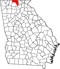 | |
| CDPs | ||
| Unincorporated communities | ||
| Ghost towns | ||
This article is issued from
Wikipedia.
The text is licensed under Creative Commons - Attribution - Sharealike.
Additional terms may apply for the media files.