Crater Highlands
The Crater Highlands (Ngorongoro Highlands) are a region along the East African Rift in the Arusha and Manyara Regions of northern Tanzania.
Geology
The highlands are located in a spreading zone at the intersection of branches of two tectonic plates, the African Plate and Somali Plate, resulting in distinctive and prominent landforms.[1]
The highlands are named for the many craters and calderas present. As common in spreading zones, volcanoes can be found here. Magma, rising to fill the gaps, reaches the surface and builds cones. Calderas form if a volcano explodes or collapses, following the emptying of the magma chamber below, and further spreading can fracture the volcanoes as well.[1]
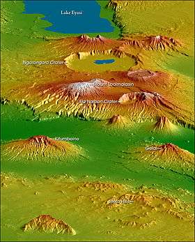
Geography
The following are considered to be within the Crater Highlands:
- Lake Eyasi
- Ngorongoro Crater
- Ela Naibori Crater
- Kitumbeine Mountain
- Gelai Mountain
- Mount Loolmalasin
- Meto Hills
Visiting the Crater Highlands
A visit to the Crater Highlands is often combined with a safari in Tanzania's top safari parks such as the Serengeti. Accommodation options range in price and level of comfort. In 2016, responsible tourism company, Asilia Africa, opened The Highlands, a unique domed property perched on the slopes of the Olmoti volcano.
Visitors to the area can enjoy a variety of scenic walks and hikes requiring various fitness levels, as well as trips to the famous Ngorongoro Crater, as well as visits to local villages.
References
- 1 2 "Crater Highlands". Earth Observatory. NASA. Retrieved 29 September 2017.
See also
- Volcanoes of Tanzania