Cranbrook, British Columbia
| Cranbrook | ||
|---|---|---|
| City | ||
| City of Cranbrook | ||
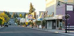 10th Ave Cranbrook | ||
| ||
| Motto(s): Mountains of Opportunity | ||
 Cranbrook Location of Cranbrook in British Columbia | ||
| Coordinates: 49°30′35″N 115°46′0″W / 49.50972°N 115.76667°WCoordinates: 49°30′35″N 115°46′0″W / 49.50972°N 115.76667°W | ||
| Country |
| |
| Province |
| |
| Regional District | East Kootenay | |
| Established | 1898 | |
| Incorporation | 1905 | |
| Government | ||
| • Mayor | Lee Pratt[1] | |
| • Governing body | Cranbrook City Council | |
| • MP | Wayne Stetski | |
| • MLA | Tom Shypitka | |
| Area | ||
| • Total | 31.95 km2 (12.34 sq mi) | |
| • Agglomeration | 4,568.03 km2 (1,763.73 sq mi) | |
| Elevation | 921 m (3,021 ft) | |
| Population (2016) | ||
| • Total | 19,259 | |
| • Density | 604.7/km2 (1,566/sq mi) | |
| • Agglomeration | 26,083 | |
| • Demonym | Cranbrookite, Cranbrookian | |
| Time zone | UTC-7 (Mountain Standard (MST)) | |
| • Summer (DST) | UTC-6 (Mountain Daylight (MDT)) | |
| Forward sortation area | V1C | |
| Area code(s) | 236, 250, 778 | |
| Telephone Exchanges | 236-363, 250-417, 250-420, 250-421, 250-426, 250-464, 250-489, 250-581, 250-919, 778-261, 778-450, 778-517, 778-520, 778-550, 778-570, 778-687, 778-761, 778-963 | |
| NTS Map | 082G05 | |
| GNBC Code | JAIQY | |
| Highways |
| |
| Website | City of Cranbrook | |
| City Data[2] | ||
Cranbrook (/ˈkrænbrʊk/ KRAN-bruuk) is a city in southeast British Columbia, Canada, located on the west side of the Kootenay River at its confluence with the St. Mary's River,[3] It is the largest urban centre in the region known as the East Kootenay. As of 2016, Cranbrook's population is 19,259[4] with a census agglomeration population of 26,083. It is the location of the headquarters of the Regional District of East Kootenay and also the location of the regional headquarters of various provincial ministries and agencies, notably the Rocky Mountain Forest District.
Cranbrook is home to the Canadian Museum of Rail Travel which presents static exhibits of passenger rail cars built in the 1920s for the CPR and in the 1900s for the Spokane International Railway. It is also the home of the Kootenay Ice, a WHL hockey team, which has won the league title three times and the Memorial Cup once.
History
Originally inhabited by Ktunaxa peoples, the land that Cranbrook now occupies was bought by European settlers, notably Colonel James Baker who named his newly acquired land Cranbrook after his home in Cranbrook, Kent, England.
In 1898, Baker had successfully convinced Canadian Pacific Railway to establish their Crowsnest Pass line through Cranbrook rather than nearby Gold Rush Boom Town Fort Steele. With that accomplishment Cranbrook became the major centre of the region, while Fort Steele declined; however, the latter is today a preserved heritage town.
On November 1, 1905, Cranbrook was incorporated as a city.
Some of the major industries include mining and forestry services, trades, and health care.
Geography
While much of the city is relatively flat, Cranbrook is surrounded by many rising hills where many residential homes are located.[5] Cranbrook faces the Purcell Mountains to the west and the Rocky Mountains to the north and east. There are many lakes in close proximity to Cranbrook. Some of these lakes include Jim Smith Lake, Wasa Lake, Lazy Lake, Moyie Lake, Monroe Lake, Norbury Lake and Elizabeth Lake. Many of these lakes contain opportunities for boating, fishing and camping. There are public recreational beaches and provincial campgrounds.
Climate
Cranbrook features a humid continental climate under the Köppen climate classification. Environment Canada reports Cranbrook as having the most sunshine hours of any BC city at approximately 2190.5 hours annually. It is a fairly dry city throughout the year, and when precipitation does fall a good percentage of it will be in the form of snow. Environment Canada also states that the city experiences some of the lightest wind speeds year-round, has few foggy days, and has among the highest average barometric pressure of any city in Canada.[6] Frost-free days average 110 days, typically occurring between May 26 to September 14. Mean daily temperatures range from −8.3 °C (17.1 °F) to 18.2 °C (64.8 °F). However, temperatures can range from −20 °C (−4.0 °F) in the winter to 35 °C (95.0 °F) in the summer months. Overall, its climate is extremely similar to that of Kelowna, in the nearby Okanagan Valley to the west - especially in regard to precipitation patterns and total monthly accumulation. However, Kelowna is significantly warmer throughout all seasons.
The highest temperature ever recorded in Cranbrook was 40.5 °C (105 °F) on August 10th, 2018.[7] The coldest temperature ever recorded was −41.1 °C (−42 °F) on January 19, 1958.[8]
| Climate data for Cranbrook International Airport, 1981–2010 normals, extremes 1901–present[lower-alpha 1] | |||||||||||||
|---|---|---|---|---|---|---|---|---|---|---|---|---|---|
| Month | Jan | Feb | Mar | Apr | May | Jun | Jul | Aug | Sep | Oct | Nov | Dec | Year |
| Record high °C (°F) | 13.9 (57) |
13.5 (56.3) |
22.4 (72.3) |
30.6 (87.1) |
34.2 (93.6) |
37.4 (99.3) |
38.9 (102) |
40.5 (104.9) |
33.9 (93) |
29.4 (84.9) |
19.5 (67.1) |
13.3 (55.9) |
40.5 (104.9) |
| Average high °C (°F) | −1.9 (28.6) |
1.9 (35.4) |
7.5 (45.5) |
12.9 (55.2) |
17.9 (64.2) |
21.6 (70.9) |
26.2 (79.2) |
26.0 (78.8) |
19.9 (67.8) |
11.7 (53.1) |
2.7 (36.9) |
−3.4 (25.9) |
11.9 (53.4) |
| Daily mean °C (°F) | −6.1 (21) |
−3.2 (26.2) |
2.0 (35.6) |
6.6 (43.9) |
11.3 (52.3) |
15.0 (59) |
18.7 (65.7) |
18.2 (64.8) |
12.6 (54.7) |
5.7 (42.3) |
−1.3 (29.7) |
−7.2 (19) |
6.0 (42.8) |
| Average low °C (°F) | −10.2 (13.6) |
−8.3 (17.1) |
−3.5 (25.7) |
0.3 (32.5) |
4.7 (40.5) |
8.4 (47.1) |
11.2 (52.2) |
10.3 (50.5) |
5.3 (41.5) |
−0.3 (31.5) |
−5.2 (22.6) |
−11.0 (12.2) |
0.1 (32.2) |
| Record low °C (°F) | −41.1 (−42) |
−37.2 (−35) |
−30.0 (−22) |
−17.2 (1) |
−12.2 (10) |
−4.4 (24.1) |
−1.7 (28.9) |
−5.0 (23) |
−12.2 (10) |
−29.4 (−20.9) |
−31.8 (−25.2) |
−40.0 (−40) |
−41.1 (−42) |
| Average precipitation mm (inches) | 25.5 (1.004) |
18.9 (0.744) |
22.2 (0.874) |
24.6 (0.969) |
46.1 (1.815) |
62.2 (2.449) |
38.3 (1.508) |
28.0 (1.102) |
31.3 (1.232) |
20.1 (0.791) |
35.3 (1.39) |
32.7 (1.287) |
385.3 (15.169) |
| Average rainfall mm (inches) | 4.5 (0.177) |
4.2 (0.165) |
10.8 (0.425) |
19.9 (0.783) |
44.1 (1.736) |
62.1 (2.445) |
38.3 (1.508) |
28.0 (1.102) |
30.8 (1.213) |
16.5 (0.65) |
14.5 (0.571) |
5.8 (0.228) |
279.5 (11.004) |
| Average snowfall cm (inches) | 25.3 (9.96) |
18.2 (7.17) |
12.5 (4.92) |
5.4 (2.13) |
1.5 (0.59) |
0.0 (0) |
0.0 (0) |
0.0 (0) |
0.6 (0.24) |
3.8 (1.5) |
23.7 (9.33) |
34.4 (13.54) |
125.3 (49.33) |
| Average precipitation days (≥ 0.2 mm) | 11.1 | 8.5 | 9.2 | 8.8 | 11.6 | 13.6 | 9.2 | 8.4 | 8.4 | 8.2 | 11.8 | 12.8 | 121.5 |
| Average rainy days (≥ 0.2 mm) | 2.8 | 2.5 | 5.4 | 7.3 | 11.4 | 13.6 | 9.2 | 8.4 | 8.4 | 7.4 | 5.7 | 2.3 | 84.2 |
| Average snowy days (≥ 0.2 cm) | 10.4 | 7.2 | 5.6 | 2.7 | 0.7 | 0.0 | 0.0 | 0.0 | 0.1 | 1.2 | 7.6 | 12.2 | 47.8 |
| Average relative humidity (%) (at 3pm) | 70.6 | 58.7 | 47.7 | 40.9 | 41.0 | 42.2 | 35.7 | 35.6 | 41.3 | 49.7 | 67.1 | 73.4 | 50.3 |
| Mean monthly sunshine hours | 63.5 | 106.9 | 163.2 | 215.0 | 256.7 | 267.8 | 315.1 | 302.7 | 218.2 | 159.5 | 69.8 | 51.9 | 2,190.5 |
| Percent possible sunshine | 23.7 | 37.5 | 44.4 | 52.2 | 54.0 | 55.0 | 64.2 | 67.7 | 57.5 | 47.6 | 25.5 | 20.4 | 45.8 |
| Source: Environment Canada[7][9][10][11][12] | |||||||||||||
Demographics
| Canada 2016 Census | Population | % of Total Population | |
|---|---|---|---|
| Visible minority group Source:[13] | Chinese | 180 | 0.9% |
| South Asian | 155 | 0.8% | |
| Black | 115 | 0.6% | |
| Filipino | 125 | 0.6% | |
| Latin American | 45 | 0.2% | |
| Southeast Asian | 60 | 0.3% | |
| Arab | 25 | 0.1% | |
| West Asian | 20 | 0.1% | |
| Korean | 85 | 0.4% | |
| Japanese | 110 | 0.6% | |
| Other visible minority | 0 | 0% | |
| Mixed visible minority | 70 | 0.4% | |
| Total visible minority population | 1,000 | 5.1% | |
| Aboriginal group Source:[14] | First Nations | 660 | 3.4% |
| Métis | 995 | 5.1% | |
| Inuit | 20 | 0.1% | |
| Total Aboriginal population | 1,710 | 8.7% | |
| European Canadian | 16,850 | 86.1% | |
| Total population | 19,560 | 100% | |
Education
Schools
Public schools are run by School District 5 Southeast Kootenay, consisting of seven elementary schools and two middle schools that feed into the city's only high school: Mount Baker Secondary School, home to approximately 1,000 students and 90 staff members. Mount Baker is the largest high school in school district five. Prior to 2004, the middle schools were referred to as junior high schools housing grades 8-10 rather than the current 7-9. However, due to declining enrollment, the school district adopted the new system. There is also a local home-school network.
The following 13 schools are located in Cranbrook.
- Aqamnik Elementary School (First Nations school located in St. Mary's Band)
- Amy Woodland Elementary
- Gordon Terrace Elementary
- Highlands Elementary School
- Kootenay Christian Academy
- Kootenay Orchards Elementary School
- Laurie Middle School
- Mount Baker Secondary School
- Parkland Middle School
- Pinewood Elementary School
- St. Mary's Catholic Independent School (private school)
- Steeples Elementary School
- T M Roberts Elementary School
Post-secondary education
Cranbrook is home to the main campus of the College of the Rockies, which has over 2,500 full and part-time students from over 21 countries.[15]
Transportation
Cranbrook is at the junction of major highways 3 and 93/95, and due to its close proximity to the borders of Alberta and the United States, it is an important transportation hub. Cranbrook has a major Canadian Pacific Railway yard, which serves as a key gateway for trains arriving from and departing to the United States.
The McPhee Bridge also known as the St. Mary's Bridge rises high above the St. Mary River and is near the Canadian Rockies International Airport and the Shadow Mountain Golf Community. It supports the thousands of people who travel between Kimberley and Cranbrook on highway 95A.
Approximately 9 km (6 mi) north is the Canadian Rockies International Airport, which has recently completed its 12.5 million dollar expansion including the lengthening of its runway from 6000 to 8000 feet in order to accommodate a limited number of international flights and an expansion to the Terminal for more passengers. The airport is served by Air Canada Jazz to Vancouver and Calgary, Pacific Coastal Airlines to Vancouver and Kelowna. On February 11, 1978, Pacific Western Airlines Flight 314, a Boeing 737-200, nearly impacted a snowplow on the runway at the airport in Cranbrook, then lost control and crashed, killing 42 of the 49 people on board.
Cranbrook has a public transit system operated by BC Transit, which runs buses on eight different lines.[16]
Sports and recreation
Western Financial Place (formerly called the RecPlex) is a pool and hockey arena in Cranbrook that opened in 2000 and is home to the Kootenay Ice.[17] A paved, two-lane 28 km (17 mi) trail exists between Cranbrook and Kimberley, BC.[18] This trail constitutes a section of the Trans-Canada Trail and is known as the Rails to Trails. Canadian Pacific Railway donated the rail right-of-way and the teardown of the railway began by CP Rail in 2009.[19] In addition to this trail, there are 2000 acres of wilderness to explore in the community forest.[20]
Media
- Newspapers
- Cranbrook Daily Townsman - Daily paper
- Radio stations
- 101.3 FM - CBRR-FM, CBC Radio One (repeats CBTK-FM, Kelowna)
- 102.9 FM - CHDR-FM, The Drive, Rock
- 104.7 FM - CHBZ-FM, B-104, Country
- 106.5 FM - VF2497, Christian Family Radio (repeats VOAR, Mount Pearl, Newfoundland and Labrador)
- 107.5 FM - CFSM-FM, Summit 107, Adult Contemporary
- Television
Notable people
The following notable people come from or were born in Cranbrook:
|
|
Sister cities
Cranbrook is twinned with

References
- ↑ Meet Our Mayor | City of Cranbrook
- ↑ "Population, Age characteristics, Dwellings, Houses, Language, Education, Work, Industry, Earnings, Income, Immigration, Citizenship, Labor". www.city-data.com. Retrieved November 16, 2015.
- ↑ BCGNIS entry "Cranbrook (city)"
- ↑ http://www12.statcan.gc.ca/census-recensement/2016/dp-pd/prof/details/page.cfm?Lang=E&Geo1=POPC&Code1=0210&Geo2=PR&Code2=47&Data=Count&SearchText=Cranbrook&SearchType=Begins&SearchPR=01&B1=All&TABID=1
- ↑ City of Cranbrook website.
- ↑ "Archived copy". Archived from the original on July 11, 2006. Retrieved July 10, 2006.
- 1 2 "Daily Data Report for August 2018 - Climate - Environment and Climate Change Canada". climate.weather.gc.ca. Retrieved 12 August 2018.
- ↑ "Daily Data Report for January 1958". Environment Canada. Retrieved February 26, 2017.
- ↑ "Canadian Climate Normals 1981-2010 Station Data". Environment Canada. Retrieved May 27, 2016.
- ↑ "Cranbrook". Environment Canada. Retrieved February 26, 2017.
- ↑ "Cranbrook A". Environment Canada. Retrieved February 26, 2017.
- ↑ "Cranbrook Airport Auto". Environment Canada. Retrieved February 26, 2017.
- ↑ "Community Profiles from the 2006 Census, Statistics Canada - Census Subdivision". 2.statcan.gc.ca. December 6, 2010. Retrieved April 13, 2013.
- ↑ "Aboriginal Peoples - Data table". 2.statcan.ca. October 6, 2010. Retrieved April 13, 2013.
- ↑ College of the Rockies website
- ↑ Cranbrook Transit System.
- ↑ "Cranbrook Rec Plex Becomes Western Financial Place", Cranbrook, August 1, 2012.
- ↑ "The Trail", North Star Rails to Trails.
- ↑ "History of the Trail", North Star Rails to Trails.
- ↑ Cranbrook Community Forest Society web
- ↑ Climate data was recorded at Cranbrook from January 1901 to March 1939 and at Cranbrook Airport from February 1938 to present.
External links
| Wikimedia Commons has media related to Cranbrook, British Columbia. |

- City of Cranbrook
| Subdivisions |  | |
|---|---|---|
| Communities | ||
| Metro areas and agglomerations | ||
| Cities |
| |
| ||