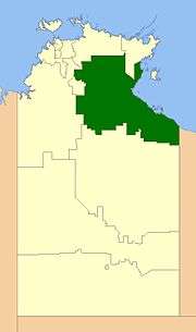
Roper Gulf Region
| Roper Gulf Shire Northern Territory | |||||||||||||||
|---|---|---|---|---|---|---|---|---|---|---|---|---|---|---|---|
 | |||||||||||||||
| Population | 6,505 (2016 census)[1] | ||||||||||||||
| • Density | 0.0351287/km2 (0.090983/sq mi) | ||||||||||||||
| Established | 2008 | ||||||||||||||
| Area | 185,176 km2 (71,496.9 sq mi) | ||||||||||||||
| Mayor | Judy MacFarlane | ||||||||||||||
| Council seat | Katherine (outside LGA) | ||||||||||||||
| Region | Katherine Region | ||||||||||||||
| Territory electorate(s) | Arnhem, Barkly | ||||||||||||||
| Federal Division(s) | Lingiari | ||||||||||||||
 | |||||||||||||||
| Website | Roper Gulf Shire | ||||||||||||||
| |||||||||||||||
The Roper Gulf Region is a local government area of the Northern Territory, Australia. The region covers an area of 185,176 square kilometres (71,497 sq mi) and had a population of around 6,500 at the 2016 Census.
History
In October 2006 the Northern Territory Government announced the reform of local government areas. The intention of the reform was to improve and expand the delivery of services to towns and communities across the Northern Territory by establishing eleven new shires. The Roper-Gulf Shire was created on 1 July 2008 as were the remaining ten shires. On 1 January 2014, the Shire was renamed to Roper Gulf Region.
Elections of Shire Councillors were held on 25 October 2008.
Most of the area of the Shire was previously unincorporated, but it absorbed several small LGAs on incorporation:
- Borroloola Community
- Numbulwar Numburindi Community
- Nyirranggulung Mardrulk Ngadberre Regional Council
- Yugul Mangi Community
- Mataranka Community
- Jilkminggan Community
Wards
The Roper Gulf Regional Council is divided into 5 wards, which is governed by 11 councillors across four wards:
- Never Never Ward (3)
- Numbulwar Numburindi Ward (1)
- Nyirranggulung Ward (3)
- South West Gulf Ward (3)
- Yugul Mangi Ward (2)
Towns
References
- ↑ Australian Bureau of Statistics (27 June 2017). "Roper Gulf (R)". 2016 Census QuickStats. Retrieved 9 December 2017.

External links
- Roper Gulf Shire website
- Map of LGAs
- Policy details
- Map of Roper Gulf Shire with ward and property divisions
- Map of Roper Gulf Shire with ward area figures
Coordinates: 14°28′01″S 132°16′01″E / 14.4670°S 132.2670°E