County Route 505 (New Jersey)
| ||||
|---|---|---|---|---|
_map.svg.png) CR 505 highlighted in red | ||||
| Route information | ||||
| Length | 20.64 mi[1] (33.22 km) | |||
| Major junctions | ||||
| South end |
| |||
|
| ||||
| North end |
| |||
| Location | ||||
| Counties | Hudson, Bergen | |||
| Highway system | ||||
| ||||

County Route 505, abbreviated CR 505, is a county highway in the U.S. state of New Jersey. The highway extends 20.64 miles (33.22 kilometers) from John F. Kennedy Boulevard (CR 501) in Union City to the New York state line in Northvale.
Route description
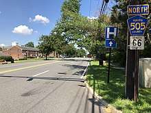
County Route 505 begins at County Route 501 in Union City, where it travels east and soon aftering entering Weehawken, it is named Boulevard East. It proceeds northward, traveling parallel to the Hudson River atop the Hudson Palisades. At Anthony M. DeFino Way in West New York it takes a right turn and descends to the waterfront becoming River Road through North Bergen and Edgewater, where it then intersects Route 5. In Fort Lee it intersects with Interstate 95.[2] CR 505 then intersects the Palisades Interstate Parkway, before traveling parallel to it. It then intersects County Route 501, before turning due north from the westward path it had previously followed along. It travels by Morrow Park, shortly before traveling near the Knickerbocker Country Club. It then intersects County Route 70, before continuing north and intersecting County Route 502.[3] From there, it proceeds north, reaching its end at the New York/New Jersey border.[4]
History
CR 505 was originally intended to be a spur of New Jersey Route 303.[5]
The 1955 USGS map of the Park Ridge Quadrangle shows CR 505 running south from the New York state line on Spring Valley Road in Montvale, then east on Grand Avenue, and south on Pascack Road through Park Ridge, Woodcliff Lake, and Hillsdale, all several miles west of its modern-day alignment.
Bike lanes on River Road were completed on July 24, 2012, in connection with a road re-paving project. They run a half mile from Palisades Medical Center in North Bergen and stretch southward towards Bulls Ferry Road in Weehawken.[6]
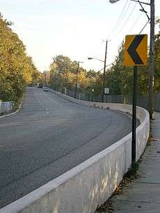
There are numerous bridges along Boulevard East crossing over clefts in the cliffs, many approaching 100 years in age.[7] A portion of the road will be closed for six-months in 2013 to replace one located in North Bergen.[8][9]
Major intersections
| County | Location | mi[1] | km | Destinations | Notes |
|---|---|---|---|---|---|
| Hudson | Union City | 0.00 | 0.00 | Southern terminus | |
| Bergen | Edgewater | 5.70 | 9.17 | ||
| Fort Lee | 7.52 | 12.10 | Interchange | ||
| Englewood Cliffs | 9.50 | 15.29 | Exit 1 on Palisades Parkway | ||
| 9.62 | 15.48 | CR 505 Truck leaves CR 505 | |||
| Englewood | 11.04 | 17.77 | CR 505 Truck re-joins CR 505 | ||
| Closter | 17.07 | 27.47 | |||
| Northvale | 20.64 | 33.22 | New York border, northern terminus | ||
| 1.000 mi = 1.609 km; 1.000 km = 0.621 mi | |||||
CR 505 Truck
| |
|---|---|
| Location | Englewood Cliffs-Englewood |
| Length | 4.65 mi[10][11][12] (7.48 km) |
County Route 505 Truck is a truck route bypassing the steep portion of CR 505 between US 9W in Englewood Cliffs and CR 501 in Englewood. The route follows US 9W south to Fort Lee before heading west along Route 4 to Englewood, where it heads north on CR 501.[13]
Major intersections
The entire route is in Bergen County.
| Location | mi[10][11][12] | km | Destinations | Notes | |
|---|---|---|---|---|---|
| Englewood Cliffs | 0.00 | 0.00 | Southern terminus, south end of US 9W overlap | ||
| Fort Lee | 1.54 | 2.48 | Interchange | ||
| 2.02 | 3.25 | Interchange, north end of US 9W overlap, south end of Route 4 overlap | |||
| 2.16– 2.26 | 3.48– 3.64 | Southbound exit and northbound entrance | |||
| Englewood | 3.23 | 5.20 | Jones Road | Interchange | |
| 3.81 | 6.13 | Interchange, north end of Route 4 overlap, south end of CR 501 overlap | |||
| 4.65 | 7.48 | Northern terminus, north end of CR 501 overlap | |||
| 1.000 mi = 1.609 km; 1.000 km = 0.621 mi | |||||
See also

References
- 1 2 "County Route 505 Straight Line Diagram" (PDF). New Jersey Department of Transportation. Retrieved May 28, 2012.
- ↑ Google Maps (2008). "Overview of County Route 505 from Union City to Fort Lee". Retrieved 2008-02-08.
- ↑ Google Maps (2008). "Overview of County Route 505". Retrieved 2008-02-08.
- ↑ Google Maps (2008). "Overview of County Route 505". Retrieved 2008-02-08.
- ↑ New Jersey Roads - NJ State Highways - CR 200-514
- ↑ Cruz, Vanessa. "If you build it, they will ride". The Union City Reporter. December 2, 2012. p. 4.
- ↑ "Historic Bridge Survey (1991-1994)" (PDF). NJDOT. 2001. Retrieved 2013-03-26.
- ↑ Tat, Linh (March 25, 2013). "6-month 'headache' due on Boulevard East in North Bergen". The Record. Retrieved 2013-03-26.
- ↑ Conte, Michaelangelo (March 26, 2013). "A section of Boulevard East shutting down for four months during replacement of supporting arch". The Jersey Journal. Retrieved 2013-03-27.
- 1 2 "US 9W Straight Line Diagram" (PDF). New Jersey Department of Transportation. Retrieved May 26, 2010.
- 1 2 "Route 4 Straight Line Diagram" (PDF). New Jersey Department of Transportation. Retrieved April 8, 2007.
- 1 2 "County Route 501 Straight Line Diagram" (PDF). New Jersey Department of Transportation. Retrieved May 28, 2012.
- ↑ Google (May 28, 2012). "overview of County Route 505 Truck" (Map). Google Maps. Google. Retrieved May 28, 2012.
External links
| Wikimedia Commons has media related to County Route 505 (New Jersey). |
Route map: