County Line Bowstring
|
County Line Bowstring | |
 | |
  | |
| Location | Cloud County, Republic County |
|---|---|
| Nearest city | Wayne, Kansas |
| Coordinates | 39°39′14″N 97°34′23″W / 39.65389°N 97.57306°WCoordinates: 39°39′14″N 97°34′23″W / 39.65389°N 97.57306°W |
| Built | 1876 |
| Built by | Wrought Iron Bridge Company |
| Architect | Phoenix Bridge Co. |
| Architectural style | Bowstring pony truss |
| MPS | Metal Truss Bridges in Kansas 1861–1939 MPS |
| NRHP reference # | 89002192 |
| Added to NRHP | January 4, 1990[1] |
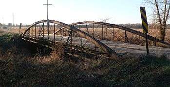
The County Line Bowstring is a bridge located near unincorporated Hollis, Kansas, United States, that is listed on the National Register of Historic Places.[1] It spans West Creek on the border between Cloud and Republic counties and has a wooden deck with a bowstring pony truss.
It is a single-span Bowstring arch truss bridge which is 80 feet (24 m) long and 16 feet (4.9 m) wide.[2]
The span was built in 1876 by the Wrought Iron Bridge Co. of Ohio, as one of four spans in a bridge crossing in Concordia, Kansas. Later the four spans were removed to different locations in the area.[2] It crosses West Creek, a tributary to the Republican River.
As of 2010, the bridge is open to one-lane automobile traffic on a low-maintenance county road.
See also
References
- 1 2 National Park Service (2009-03-13). "National Register Information System". National Register of Historic Places. National Park Service.
- 1 2 Larry Jochims (September 20, 1989). "National Register of Historic Places Inventory/Nomination:". National Park Service. Retrieved November 27, 2017. With eight photos from 1985.
- Historic Bridges of the United States (with photos and map) http://bridgehunter.com/ks/cloud/county-line/
| Topics | |
|---|---|
| Lists by states |
|
| Lists by insular areas | |
| Lists by associated states | |
| Other areas | |
| |
This article is issued from
Wikipedia.
The text is licensed under Creative Commons - Attribution - Sharealike.
Additional terms may apply for the media files.