Cottonwood Airport
| Cottonwood Airport | |||||||||||
|---|---|---|---|---|---|---|---|---|---|---|---|
 | |||||||||||
| Summary | |||||||||||
| Airport type | Public | ||||||||||
| Owner | City of Cottonwood | ||||||||||
| Serves | Cottonwood, Arizona | ||||||||||
| Elevation AMSL | 3,560 ft / 1,085 m | ||||||||||
| Coordinates | 34°43′48″N 112°02′06″W / 34.73000°N 112.03500°WCoordinates: 34°43′48″N 112°02′06″W / 34.73000°N 112.03500°W | ||||||||||
| Map | |||||||||||
 P52  P52 | |||||||||||
| Runways | |||||||||||
| |||||||||||
| Statistics (2015) | |||||||||||
| |||||||||||
|
Source: Federal Aviation Administration | |||||||||||
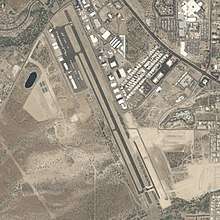
Cottonwood Airport (IATA: CTW, FAA LID: P52) is a city-owned, public-use non-towered airport located 1.15 miles (1.00 nmi; 1.85 km) southwest of the central business district of Cottonwood, a city in Yavapai County, Arizona, United States[1] and 90 miles (78 nmi; 140 km) north of Phoenix Sky Harbor International Airport.
Although most U.S. airports use the same three-letter location identifier for the FAA and IATA, Cottonwood Airport is assigned P52 by the FAA and CTW by the IATA.[2]
Facilities and aircraft
Cottonwood Airport covers an area of 210 acres (85 ha) at an elevation of 3,560 ft (1,090 m) above mean sea level. It has one runway:
For the 12-month period ending April 23, 2015, the airport had 18,900 aircraft operations, an average of 51 per day: 98% general aviation, 1.75% air taxi, and .25% military. At that time there were 13 aircraft based at this airport: 73% single-engine, 2% ultralight, 15% multi-engine, no jet, and no helicopters.
References
- ↑ "FAA Airport Master Record for P52". Federal Aviation Administration. Retrieved 5 May 2018.
- ↑ "CTW - Cottonwood, AZ, US - Airport - Great Circle Mapper". www.gcmap.com. Retrieved 2018-05-06.
- ↑ "AirNav: P52 - Cottonwood Airport". www.airnav.com. Retrieved 2018-05-06.
External links
- FAA Terminal Procedures for P52, effective September 13, 2018
- Resources for this airport:
- FAA airport information for P52
- AirNav airport information for KP52
- FlightAware airport information and live flight tracker
- NOAA/NWS latest weather observations
- SkyVector aeronautical chart, Terminal Procedures