Col de la Traversette
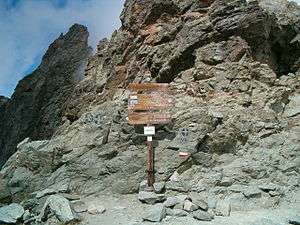
The Col de la Traversette (Italian: Colle delle Traversette) is a bridle pass with an altitude of 2,947 m in the Cottian Alps. Located between Crissolo and Abriès it represents the border between Italy and France and separates the Monviso (3,841 m) from the Monte Granero (3,171 m). The Blue Trail of the Via Alpina and the Giro di Viso cross the pass.
The 75 m long Monte Viso Tunnel (French: Tunnel de la Traversette, Italian: Buco di Viso) is a pedestrian tunnel constructed between 1478 and 1480 to bypass the Col.
Possible site of Hannibal's Alpine crossing
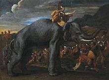
In the 1950s, Gavin de Beer was the first to propose the pass as the likely site where Hannibal had crossed the Alps.[1] However, eminent Polybian scholar F. W. Walbank rejected de Beer's theory in 1956.[2] But de Beer's thesis received renewed support in 2016 when geologist William Mahaney et al. reported that sediments had been identified near the pass that had been churned up by "the constant movement of thousands of animals and humans" and dated them to approximately 218 B.C., the time of Hannibal's invasion.[1][3][4]
However, the radiocarbon dating method used to process the Mahaney expedition samples had a standard deviation of plus or minus 60 years, so Mahaney's findings were not definitive despite widespread speculation at the time.[5] In particular, no Carthaginian artifacts (or elephant bones) attributable to the numerous fatalities suffered by the army have been found. [5]
References
- 1 2 Philip Ball (April 3, 2016). "The truth about Hannibal's route across the Alps". The Guardian. Retrieved April 5, 2016.
- ↑ Walbank, F.W. (1956). "Some Reflections on Hannibal's Pass". The Journal of Roman Studies. Cambridge University Press. 46: 37–45. doi:10.2307/297963. JSTOR 297963.
- ↑ "Dung clue to Hannibal's Alpine crossing". BBC News. April 5, 2016.
- ↑ "Researchers Find Hannibal's Route through Alps". The British Journal. April 8, 2016. Retrieved 2016-04-08.
- 1 2 Mary Harrsch (April 13, 2016). "Hannibal's Route Over The Alps or just Horse S***?". Blogger. Retrieved April 17, 2016.
External links
| Wikimedia Commons has media related to Col de la Traversette. |