Minnesota State Highway 55
| ||||
|---|---|---|---|---|
| Olson Memorial Highway | ||||
| Route information | ||||
| Maintained by MnDOT | ||||
| Length | 220.572 mi[1] (354.976 km) | |||
| Existed | 1933 – present | |||
| Major junctions | ||||
| West end |
| |||
| ||||
| East end |
| |||
| Location | ||||
| Counties | Wilkin, Grant, Douglas, Pope, Stearns, Kandiyohi, Meeker, Wright, Hennepin, Dakota | |||
| Highway system | ||||
| ||||

Minnesota State Highway 55 (MN 55) is a highway in west-central, central, and east-central Minnesota, which runs from the North Dakota state line near Tenney and continues east and southeast to its eastern terminus at its intersection with U.S. Highway 61 in Hastings.
This route, signed east–west, runs roughly diagonally across the central part of Minnesota.
Highway 55 is 221 miles (356 km) in length.
Route description
Highway 55 serves as a northwest–southeast route between Elbow Lake, Glenwood, Paynesville, Annandale, Buffalo, Plymouth, Minneapolis, Mendota Heights, and Hastings.
Highway 55 begins at the Bois de Sioux River, at the Minnesota — North Dakota state line near Tenney. North Dakota Highway 11 is its counterpoint upon crossing the state line. Highway 55 continues east to Tenney, Nashua, and Wendell. The route has a junction with U.S. Highway 59 before entering the city of Elbow Lake. Highways 55 and 59 run concurrently for 11 miles until reaching Barrett.
Highway 55 then continues independently again to Hoffman, Kensington, Farwell, and Lowry before reaching the city of Glenwood. At Glenwood, Highway 55 has an intersection with State Highway 29 and an interchange with State Highway 28.
The route continues southeast to Sedan and Brooten before reaching its junction with U.S. Highway 71 in Belgrade. Highway 55 passes through Regal before reaching its junction with State Highways 4 and 23 at the city of Paynesville.
Highway 55 continues east to Eden Valley and Watkins before reaching its junction with State Highway 15 at Kimball.
The route has a junction with State Highway 24 in Annandale. Highway 55 continues to Maple Lake and then Buffalo, where it has a junction with State Highway 25.
Highway 55 enters the Twin Cities area at Rockford and Greenfield, continuing east to Medina and Plymouth. Highway 55 has a junction with I-494 in Plymouth. Highway 55 continues east and has a junction with U.S. Highway 169 at the Plymouth / Golden Valley boundary line. Highway 55 continues through Golden Valley to its junction with State Highway 100. The route then continues east and enters the city of Minneapolis.
The highway has been designated Olson Memorial Highway,[2] named for Floyd B. Olson, a popular Minnesota governor of Norwegian ancestry. Olson grew up in North Minneapolis, near where the highway runs. While the entire route is designated as the Olson Memorial Highway, it is only consistently signed as such between Interstate 494 and N 7th Street in Minneapolis. The part of Highway 55 southeast of downtown is known as Hiawatha Avenue. Light rail trains on the Blue Line run parallel to the highway for much of the Hiawatha Avenue stretch.

In July 2005, the section of Highway 55 that runs through downtown Minneapolis was turned back to local maintenance. To fill the gap, Highway 55 was rerouted along Interstate 94. Westbound, 55 now exits just before downtown at the westbound I-94 exit, and leaves the concurrency at the exit for the Olson Highway, marked with the Highway 55 shield. Eastbound, 55 leaves the Olson Highway at the interchange for I-94 eastbound, and leaves the freeway at the exit for Hiawatha Avenue, which is also marked with the Highway 55 shield.
There has been some controversy with expansion of the highway. An area known as Camp Coldwater, considered by some as the "birthplace of Minnesota," was dug up during some construction. Highway 55 has a junction with State Highway 62 at this point.
Fort Snelling State Park is located near the junction of Highway 55 and State Highway 5. The park entrance is located on Highway 5 at Post Road.
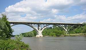
Highway 55 crosses the Minnesota River via the Mendota Bridge, which was the longest continuous bridge made of poured concrete when it was completed in 1926. It is 4,119 feet (1,255 m) in length.
The route enters Mendota Heights and has a junction with State Highways 13 and 110.
Highway 55 continues southeast through Eagan, joining briefly with State Highway 149. The route then has a junction with State Highway 3 in Inver Grove Heights. Highway 55 then runs concurrent with U.S. Highway 52 through Inver Grove Heights and into Rosemount. At Rosemount, Highway 55 leaves U.S. 52. Highway 55 continues independently again to its eastern terminus at its intersection with U.S. Highway 61 in the city of Hastings.
History
Highway 55 was authorized in 1933.[3]
Major intersections
| County | Location | mi[1] | km | Destinations | Notes | ||
|---|---|---|---|---|---|---|---|
| Bois de Sioux River | 0.000 | 0.000 | Continuation into North Dakota | ||||
| North Dakota–Minnesota state line | |||||||
| Wilkin | Campbell Township | 3.496 | 5.626 | ||||
| Champion Township | 10.706 | 17.230 | |||||
| Grant | Pomme de Terre Township | 27.832 | 44.791 | Western end of US 59 overlap | |||
| Elbow Lake | 31.230 | 50.260 | |||||
| 31.892 | 51.325 | ||||||
| Barrett | 38.820 | 62.475 | Eastern end of US 59 overlap | ||||
| Hoffman | 45.686 | 73.524 | |||||
| Pope | Ben Wade Township | 61.135 | 98.387 | Western end of MN 114 overlap | |||
| Lowry | 61.798 | 99.454 | Eastern end of MN 114 overlap | ||||
| Reno Township | 68.804 | 110.729 | |||||
| Glenwood | 70.914 | 114.125 | Interchange | ||||
| Stearns | Belgrade | 93.643 | 150.704 | Western end of US 71 overlap | |||
| Crow River Township | 94.636 | 152.302 | Eastern end of US 71 overlap | ||||
| Kandiyohi | Roseville Township | 105.917 | 170.457 | Western end of MN 4 overlap | |||
| Stearns | Paynesville | 108.205 | 174.139 | Interchange | |||
| Meeker | Union Grove Township | 113.487 | 182.640 | Eastern end of MN 4 overlap | |||
| Eden Valley | 119.497 | 192.312 | |||||
| Stearns | Kimball | 131.977 | 212.396 | Western end of MN 24 overlap | |||
| Wright | Annandale | 141.622 | 227.919 | Eastern end of MN 24 overlap | |||
| Buffalo | 155.195 | 249.762 | |||||
| Hennepin | Plymouth | 180.515 | 290.511 | Interchange; I-494 exit 22 | |||
| Plymouth–Golden Valley line | 183.052 | 294.594 | Interchange | ||||
| Golden Valley | 186.600 | 300.304 | Interchange | ||||
| Minneapolis | 189.640 | 305.196 | Western end of I-94 overlap; I-94 exit 230 | ||||
| See I-94 | |||||||
| 191.887 | 308.812 | Eastern end of I-94 overlap; I-94 exit 234A | |||||
| 191.944 | 308.904 | Westbound left exit and eastbound left entrance | |||||
| 192.619 | 309.990 | Cedar Avenue | Interchange | ||||
| 193.521 | 311.442 | East Lake Street | Interchange | ||||
| Unorganized Territory of Fort Snelling | 197.430 | 317.733 | Interchange; western end MN 62 overlap | ||||
| 198.052 | 318.734 | Bloomington Road – Fort Snelling Historic Site | Ft. Snelling not signed eastbound | ||||
| 198.373 | 319.250 | ||||||
| Minnesota River | 198.424– 199.204 | 319.332– 320.588 | Mendota Bridge | ||||
| Dakota | Mendota Heights | 199.357 | 320.834 | Eastern end of MN 62 overlap; eastbound exit and westbound entrance | |||
| 200.141 | 322.096 | At-grade intersection | |||||
| Eagan | 202.409 | 325.746 | Western end of MN 149 overlap | ||||
| 202.943 | 326.605 | Eastern end of MN 149 overlap | |||||
| Inver Grove Heights | 205.005 | 329.924 | |||||
| 206.421 | 332.202 | Eastbound exit and westbound entrance | |||||
| 206.753 | 332.737 | Western end of US 52 overlap; westbound exit and eastbound entrance | |||||
| 328.733 | 529.044 | Former MN 56 | |||||
| Inver Grove Heights–Rosemount line | 210.290 | 338.429 | 117th Street | ||||
| Rosemount | 211.074 | 339.691 | Eastern end of US 52 overlap; eastern end of freeway section; interchange eastbound, access via connector road westbound | ||||
| Hastings | 220.572 | 354.976 | Eastern terminus | ||||
1.000 mi = 1.609 km; 1.000 km = 0.621 mi
| |||||||
References
Route map:
- 1 2 Minnesota Department of Transportation. "Statewide Trunk Logpoint Listing" (PDF). St. Paul: Minnesota Department of Transportation. Retrieved August 1, 2018.
- ↑ Minnesota Statutes section 161.14 subd. 3 - https://www.revisor.mn.gov/statutes/?id=161.14
- ↑ Riner, Steve. "Details of routes 51–75". The Unofficial Minnesota Highways Page. Self-published. Retrieved October 23, 2010.