Conowingo, Maryland
| Conowingo, Maryland | |
|---|---|
| Unincorporated community | |
 Conowingo Location within the state of Maryland  Conowingo Conowingo (the US) | |
| Coordinates: 39°40′40″N 76°09′33″W / 39.67778°N 76.15917°WCoordinates: 39°40′40″N 76°09′33″W / 39.67778°N 76.15917°W | |
| Country | United States |
| State | Maryland |
| County | Cecil |
| Elevation | 289 ft (88 m) |
| Time zone | UTC-5 (Eastern (EST)) |
| • Summer (DST) | UTC-4 (EDT) |
| ZIP code | 21918 |
| Area code(s) | 410, 443, and 667 |
| GNIS feature ID | 590012[1] |
Conowingo is a small community in western Cecil County, Maryland, United States.
Conowingo is a Susquehannock word for "at the rapids".[2]
History
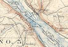
Conowingo was originally located on the eastern bank of the Susquehanna River at the confluence of the Conowingo Creek with the river. Conowingo was at the rapids that were the first navigation obstacle on the Susquehanna upstream of the Chesapeake Bay, the location of an early stretch of canal. It was also the site of the Conowingo Bridge.
A 90-foot (27.4 m) fall of the river at the rapids dictated the location of the Conowingo Dam and thus the resulting inundation of the Old Conowingo site by the subsequent Conowingo Reservoir. At the completion of the dam in 1928, the Conowingo Post Office was relocated to the hill above the dam.
Conowingo is not an incorporated municipality, nor a US Census Bureau census-designated place.
Octorara Farm was listed on the National Register of Historic Places in 1980.[3]
Conowingo Village
A new town, named Conowingo Village, was created in 1928, on the Harford County side of the dam. It was initially a company town to house the dam's plant managers and workers. From the 1980s to 2000, the power company leased the homes to non-workers. In October, 2000, the village was shuttered. And in 2001 the power company donated the land to the Maryland Department of Natural Resources and the buildings to the local fire companies for training.
Geography
- Original location: 39°40′56″N 76°11′51″W / 39.68222°N 76.19750°W
- Present location (of Post Office): 39°40′36″N 76°9′44″W / 39.67667°N 76.16222°W
References
- ↑ "Conowingo". Geographic Names Information System. United States Geological Survey.
- ↑ "Peco's Hydroelectric Station Marks 65th Anniversary -- 'A Symbol of Progress' in 1928 One of the World's Largest Power Projects".
- ↑ National Park Service (2008-04-15). "National Register Information System". National Register of Historic Places. National Park Service.
External links
- A History of Maryland’s Lower Susquehanna Region
- Larger section of the 1900 topographic map
- Section of the 1942 topographic map
- Views of the Conowingo Lake and History of the area
Municipalities and communities of Cecil County, Maryland, United States | ||
|---|---|---|
| Towns | 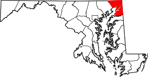 | |
| Unincorporated communities |
| |
| Ghost town | ||
| Footnotes | ‡This populated place also has portions in an adjacent county or counties | |