Conesville, New York
| Conesville, New York | |
|---|---|
| Town | |
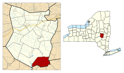 Location in Schoharie County and the state of New York. | |
| Coordinates: 42°24′35″N 74°20′19″W / 42.40972°N 74.33861°W | |
| Country | United States |
| State | New York |
| County | Schoharie |
| Area[1] | |
| • Total | 39.87 sq mi (103.26 km2) |
| • Land | 39.47 sq mi (102.22 km2) |
| • Water | 0.40 sq mi (1.05 km2) |
| Elevation | 1,457 ft (444 m) |
| Population (2010) | |
| • Total | 734 |
| • Estimate (2016)[2] | 698 |
| • Density | 17.69/sq mi (6.83/km2) |
| Time zone | UTC-5 (Eastern (EST)) |
| • Summer (DST) | UTC-4 (EDT) |
| FIPS code | 36-17651 |
| GNIS feature ID | 0978859 |
Conesville is a town in Schoharie County, New York, United States. The population was 726 at the 2000 census. The town is named after Jonathan Cone, an early resident.
The Town of Conesville is in the southeast corner of the county and is approximately 40 miles southwest of Albany.
History
Conesville was first settled around 1764 on a patent issued in 1754.
The town was formed in 1836 from the Town of Durham (now in Greene County) and the Town of Broome.
Geography
According to the United States Census Bureau, the town has a total area of 39.9 square miles (103 km2), of which, 39.5 square miles (102 km2) of it is land and 0.4 square miles (1.0 km2) of it (1.00%) is water.
The south town line is the border of Greene County. Part of the east town line borders Greene County, but the northern part borders Albany County.
The Manor Kill is a stream, fed by the Bear Kill, flowing westward into the Schoharie Reservoir near West Conesville.
New York State Route 990V is an east–west highway running from the community of Conesville to the west town line at the Schoharie Reservoir.
Demographics
| Historical population | |||
|---|---|---|---|
| Census | Pop. | %± | |
| 1840 | 1,621 | — | |
| 1850 | 1,582 | −2.4% | |
| 1860 | 1,478 | −6.6% | |
| 1870 | 1,314 | −11.1% | |
| 1880 | 1,127 | −14.2% | |
| 1890 | 929 | −17.6% | |
| 1900 | 793 | −14.6% | |
| 1910 | 708 | −10.7% | |
| 1920 | 652 | −7.9% | |
| 1930 | 569 | −12.7% | |
| 1940 | 673 | 18.3% | |
| 1950 | 626 | −7.0% | |
| 1960 | 593 | −5.3% | |
| 1970 | 489 | −17.5% | |
| 1980 | 681 | 39.3% | |
| 1990 | 684 | 0.4% | |
| 2000 | 726 | 6.1% | |
| 2010 | 734 | 1.1% | |
| Est. 2016 | 698 | [2] | −4.9% |
| U.S. Decennial Census[3] | |||
As of the census[4] of 2000, there were 726 people, 304 households, and 214 families residing in the town. The population density was 18.4 people per square mile (7.1/km²). There were 777 housing units at an average density of 19.7 per square mile (7.6/km²). The racial makeup of the town was 97.38% White, 0.28% African American, 0.28% from other races, and 2.07% from two or more races. Hispanic or Latino of any race were 1.79% of the population.
There were 304 households out of which 26.0% had children under the age of 18 living with them, 57.6% were married couples living together, 7.2% had a female householder with no husband present, and 29.3% were non-families. 26.0% of all households were made up of individuals and 13.2% had someone living alone who was 65 years of age or older. The average household size was 2.39 and the average family size was 2.85.
In the town, the population was spread out with 22.3% under the age of 18, 5.9% from 18 to 24, 24.4% from 25 to 44, 28.5% from 45 to 64, and 18.9% who were 65 years of age or older. The median age was 44 years. For every 100 females, there were 98.9 males. For every 100 females age 18 and over, there were 101.4 males.
The median income for a household in the town was $33,417, and the median income for a family was $37,344. Males had a median income of $31,250 versus $21,964 for females. The per capita income for the town was $16,236. About 5.7% of families and 7.4% of the population were below the poverty line, including 12.4% of those under age 18 and none of those age 65 or over.
Communities and locations in Conesville
- Conesville – The hamlet of Conesville is on the Manor Kill at the junction of County Roads 3 and 18 and NY-990V.
- Manor Kill – A stream running through the town to the Schoharie Reservoir.
- Manorkill – A hamlet in the eastern part of the town on County Road 3 and the Manor Kill.
- Schoharie Reservoir – a reservoir located at the west town line, constructed in 1926.
- West Conesville – A hamlet in the western part of the town on State Route 990v near the Schoharie Reservoir.
References
- ↑ "2016 U.S. Gazetteer Files". United States Census Bureau. Retrieved Jul 5, 2017.
- 1 2 "Population and Housing Unit Estimates". Retrieved June 9, 2017.
- ↑ "Census of Population and Housing". Census.gov. Archived from the original on May 12, 2015. Retrieved June 4, 2015.
- ↑ "American FactFinder". United States Census Bureau. Archived from the original on 2013-09-11. Retrieved 2008-01-31.
External links
- ConesvilleNY.com website
- Conesville, Schoharie County website
- Early history of Conesville
- Regional information
Municipalities and communities of Schoharie County, New York, United States | ||
|---|---|---|
| Villages | 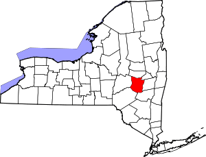 | |
| Towns | ||
| CDP | ||
| Hamlets | ||
Coordinates: 42°23′14″N 74°22′35″W / 42.38722°N 74.37639°W