Comino
| Native name: Kemmuna | |
|---|---|
 Aerial view of Comino | |
 Map of Comino | |
| Geography | |
| Location | between Gozo and Malta, south of Sicily, Mediterranean Sea |
| Coordinates | 36°00′40.6″N 14°20′12.5″E / 36.011278°N 14.336806°ECoordinates: 36°00′40.6″N 14°20′12.5″E / 36.011278°N 14.336806°E |
| Archipelago | Maltese Islands |
| Adjacent bodies of water | Mediterranean Sea |
| Area | 3.5 km2 (1.4 sq mi) |
| Administration | |
| Region | Gozo |
| Local council | Għajnsielem |
| Demographics | |
| Population | 3 (2017)[1] |
| Ethnic groups | Maltese people |
| Additional information | |
| Time zone | |
| • Summer (DST) | |
Comino (Maltese: Kemmuna), formerly called Ephaestia (Ηφαιστεία in Ancient Greek)[2][3] is a small island of the Maltese archipelago between the islands of Malta and Gozo in the Mediterranean Sea, measuring 3.5 square kilometres (1.4 sq mi) in area. Named after the cumin seed that once flourished in the Maltese islands, the island is the least densely populated area in the Republic of Malta. It has a permanent population of only three residents, following the death of the fourth resident in 2017.[1] Administratively, it is part of the municipality of Għajnsielem, in southeastern Gozo. One priest and one policeman commute from the nearby island of Gozo. The island is a bird sanctuary and nature reserve.
History
Comino is known to have been inhabited by farmers during Roman times, but for long periods in its history it has been sparsely populated, privately owned, or abandoned entirely.[4] Its rugged coastline is delineated by sheer limestone cliffs, and dotted with deep caves which were popular with pirates and marauders in the Middle Ages. The caves and coves of Comino were frequently used as staging posts for raids on hapless boats crossing between Malta and Gozo.[5] From 1285 until some time after 1290, Comino was the home of exiled Jewish Prophet and Kabbalist Abraham Abulafia. It was on Comino that Abulafia composed his "Sefer ha-Ot" (The Book of the Sign), and his last work, "Imre Shefer" (Words of Beauty).[6][7]
_01_ies.jpg)
In later years, the Knights of Malta used this island as hunting and recreational grounds. The Knights were fiercely protective of the local game, which consisted of wild boar and hares (Maltese: fenek tal-grixti): upon conviction, poachers were liable to a penalty of three years as a galley slave.[5] In the 16th and 17th centuries, Comino served as a place of imprisonment or exile for errant knights. Knights who were convicted of minor crimes were occasionally sentenced to the lonely and dangerous task of manning St. Mary's Tower.[8]
During the French occupation of Malta, Comino served as a quarantine and existing buildings served as an isolation hospital.[9]
On 6 March 1889 the British battleship HMS Sultan grounded on an uncharted rock in the Comino Channel, ripping her bottom open.[10] She slowly flooded and, in a gale on 14 March 1889 she slipped off the rock and sank. The Italian firm of Baghino & Co raised her in August 1889 for a fee of £50,000.[10] On 27 August Sultan was brought into Malta.[10][11]
Buildings and structures
St Mary's Tower

Saint Mary's Tower is the most visible structure on the island. Its background dates back to 1416, when the Maltese petitioned their king, Alfonso V of Aragon, to build a tower on Comino to serve as an early warning system in case of invasion, and to deter marauding Turks, pirates, smugglers and corsairs from using Comino as a hiding place and staging ground for devastating sorties onto the sister islands of Malta and Gozo.[12] Two years later the king levied a special tax on imported wine to raise funds for this project, but diverted the monies into his coffers; the island remained undefended for another two hundred years.[13]
Finally, in 1618 the Knights of Malta under Grandmaster Wignacourt erected St Mary's Tower (Maltese: it-Torri ta' Santa Marija), located roughly in the center of the southern coast of the island.[14] The tower formed part of a chain of defensive towers — the Wignacourt, Lascaris, and De Redin towers — located at vantage points along the coastline of the Maltese Islands, and greatly improved communications between Malta and Gozo. The tower is a large, square building with four corner turrets, located about 80 m (262 ft) above sea level. The Tower itself is about 12 m (39 ft) tall, with walls that are approximately 6 m (20 ft) thick, and is raised on a platform and plinth that are approximately 8 m (26 ft) high.[15]
During the French Blockade (1798–1800), St Mary's Tower served as a prison for suspected spies. In 1829 the British Military abandoned the site. For several decades it was deemed to be property of the local civil authorities, and may have been used as an isolation hospital, or even as a wintering pen for farm animals.[15][16] The tower again saw active service during both World War I and World War II. Since 1982 the tower has been the property of the Armed Forces of Malta. It now serves as a lookout and staging post to guard against contraband and the illegal hunting of migratory birds at sea. The tower underwent extensive restoration between 2002 and 2004. Today, it remains the most notable structure on Comino.
Comino chapel
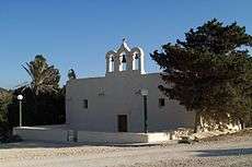
A tiny Roman Catholic chapel dedicated to the Holy Family Upon its Return from Egypt is located above Santa Marija Bay. Built in 1618, and enlarged in 1667 and again in 1716, the chapel was originally dedicated to the Annunciation. It has been deconsecrated and reconsecrated at least once in its history, when Comino was devoid of residents. The earliest record of a chapel on this site dates back to the 12th century, and can be seen in a navigational map of the period, located in the National Maritime Museum and Royal Observatory in Greenwich, London.[17]
In the past, and well into the 20th century, whenever the seas were too rough for the Gozitan priest to make the crossing to Comino for the celebration of Holy Mass, the local community would gather on the rocks at a part of the Island known as Tal-Ħmara, and gaze across the channel towards the Chapel of Our Lady of the Rocks (Maltese: il-Madonna tal-Blat), in Ħondoq ir-Rummien, Gozo, where Mass was being celebrated. They followed along with the progression of the Mass by means of a complex flag code.
Saint Mary's battery and redoubt

Saint Mary's Battery, built in 1716, at the same time as various other batteries around the coastline of mainland Malta and Gozo, is situated facing the South Comino Channel. It is a semi-circular structure with a number of embrasures facing the sea. The Battery still houses two 24-pound iron cannon, and remains in a fair state of preservation mainly due to its remote location. Its armament originally included four 6-pound iron cannon. The Battery underwent restoration in 1996 by Din l-Art Ħelwa. Saint Mary's Redoubt, an additional defensive structure, was also constructed in 1716 on the northern coast of Comino, however it was subsequently demolished.[18] The Knights also constructed army barracks on Comino. In the early 20th century the barracks were periodically used as an isolation hospital.[19]
Other
The Comino Hotel is a post-WWII structure built in the 1960s. It is located above San Niklaw Bay. There are also holiday bungalows by the Santa Marija Bay. The Comino Police Station is located between the bungalows and the Comino Chapel. It is responsible for the small community and visitors, aided by the Malta Police Force in Malta and Gozo when necessarily.
Environment and economy
The island has a karst landscape supporting sclerophyllous shrubland. Some limited afforestation with pine trees has been carried out. The sand-dunes at Santa Maria bay retain some native vegetation, including Vitex and Tamarix trees. The island has been identified as an Important Bird Area (IBA) by BirdLife International because it supports fifty to eighty breeding pairs of yelkouan shearwaters.[20]
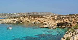
Between Comino and adjacent islet of Cominotto (Maltese: Kemmunett) lie the transparent, cyan waters of the Blue Lagoon (Maltese: Bejn il-Kmiemen, literally "Between the Cominos"). Frequented by large numbers of tourists and tour boats daily, the Blue Lagoon is a picturesque bay with a white sandy base and rich marine life. It is popular with divers, snorkelers and swimmers. Other beaches on Comino include Santa Maria Bay (Maltese: Ramla ta' Santa Marija) and St. Nicholas Bay (Maltese: Bajja San Niklaw).
Comino is a popular location for filmmakers. It appears in the films Troy, The Count Of Monte Cristo and Swept Away. Most notably, St. Mary's Tower on Comino was featured in the film The Count of Monte Cristo, where it doubled as the Château d'If.
Further reading
- Bartolo, Evarist (2013). X' taf fuq Kemuna?. imperialbandclub.com/magazine/2013. p. 138-139. Retrieved 19 July 2016.
- HMS Sultan disaster
- Gossett, William Patrick (1986) The lost ships of the Royal Navy, 1793-1900. (London: Mansell). ISBN 0-7201-1816-6
References
- 1 2 "Comino loses one of its four residents". Times of Malta. 7 May 2017. Archived from the original on 7 May 2017.
- ↑ The historical guide to the island of Malta and its dependencies. p. 79.
- ↑ Ciantar, Giovannantonio (1772). "Malta illustrata". 1–2. Stamperia del Palazzo di S.A.S. MDCCLXXII, by Giovanni Mallia: 370–371.
- ↑ Bartolo, Evarist (2013). X' taf fuq Kemuna?. imperialbandclub.com/magazine/2013. Retrieved 19 July 2016.
- 1 2 Malta Tourism Authority, "Comino" Archived 2007-01-09 at the Wayback Machine.
- ↑ Bartolo, Evarist (2013). X' taf fuq Kemuna?. imperialbandclub.com/magazine/2013. Retrieved 19 July 2016.
- ↑ http://www.independent.com.mt/articles/2014-02-10/news/hidden-traces-of-jewish-presence-in-mediaeval-malta-3911155715/
- ↑ Bartolo, Evarist (2013). X' taf fuq Kemuna?. imperialbandclub.com/magazine/2013. Retrieved 19 July 2016.
- ↑ p. 50
- 1 2 3 Gossett (1986), p.133.
- ↑ http://melitensiawth.com/incoming/Index/Melita%20Historica/MH.15(2008-11)/MH.15(2009)2/04.pdf
- ↑ R. Pullicino, "Comino"
- ↑ Christian Formosa, "St. Mary's Tower," in A Military History of Malta.
- ↑ Għajnsielem Local Council, "Places of Interest" Archived 2012-06-04 at Archive.is
- 1 2 Din l-Art Ħelwa, "Santa Marija Tower in Comino" Archived 2007-09-28 at the Wayback Machine.
- ↑ Bartolo, Evarist (2013). X' taf fuq Kemuna?. imperialbandclub.com/magazine/2013. Retrieved 19 July 2016.
- ↑ Ministry for Gozo, "il-Gżira ta' Kemmuna"
- ↑ Christian Formosa, "Map of Comino" in A Military History of Malta.
- ↑ Joseph Camilleri, l-Istorja tan-Nursing f'Malta, translated into English and edited by Catherine Sharples. Online at the Ministry of Health website.
- ↑ "Comino Island". Important Bird Areas factsheet. BirdLife International. 2013. Archived from the original on 2007-07-10. Retrieved 2013-08-07.
External links
| Wikimedia Commons has media related to Comino. |
| Wikivoyage has a travel guide for Comino. |
- Dive sites in Comino
- Comino – Travel guide on MaltaUncovered.com
- Comino, the Comino Caves & St. Mary's Tower – Photos on UnitedCominoFerries.com
| ||