Columbia Commercial Historic District (Columbia, Kentucky)
|
Columbia Commercial Historic District | |
 | |
  | |
| Location | Roughly centered around the Columbia Public Square, Columbia, Kentucky |
|---|---|
| Coordinates | 37°06′11″N 85°18′22″W / 37.10306°N 85.30611°WCoordinates: 37°06′11″N 85°18′22″W / 37.10306°N 85.30611°W |
| Area | 5.3 acres (2.1 ha) |
| NRHP reference # | 100000733[1] |
| Added to NRHP | March 13, 2017 |
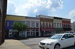
The Columbia Commercial Historic District in Columbia, Kentucky, was listed on the National Register of Historic Places in 2017.[1] It is a 5.3 acres (2.1 ha) historic district with 29 contributing buildings, two non-contributing buildings, and a non-contributing site.[2]
It is "centered on its tallest building, the National Register-listed Adair County Courthouse (1885), forming a traditional public square made by the buildings that surround the courthouse."[2]
References
- 1 2 "Weekly listings". National Park Service. March 24, 2017. Retrieved April 29, 2017.
- 1 2 Katrina Rhodes (September 1, 2016). "National Register of Historic Places Registration: Columbia Historic District" (PDF). Kentucky. Retrieved April 29, 2018. Includes 32 photos profiling buildings in the district.
| Topics | |
|---|---|
| Lists by states |
|
| Lists by insular areas | |
| Lists by associated states | |
| Other areas | |
| |
This article is issued from
Wikipedia.
The text is licensed under Creative Commons - Attribution - Sharealike.
Additional terms may apply for the media files.