Colorado State Highway 133
| ||||
|---|---|---|---|---|
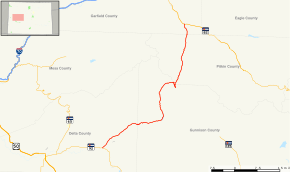 Map of western Colorado with SH 133 highlighted in red | ||||
| Route information | ||||
| Maintained by CDOT | ||||
| Length | 71.4 mi[1] (114.9 km) | |||
| Major junctions | ||||
| South end |
| |||
| North end |
| |||
| Location | ||||
| Counties | Delta, Gunnison, Pitkin, Garfield | |||
| Highway system | ||||
|
Colorado State Highways
| ||||

State Highway 133 is a 71.4 mi (114.9 km) long north–south byway connecting State Highway 82 to the north and State Highway 92 to the south, and travels through the towns of Hotchkiss, Somerset, Redstone, and Carbondale. Highway 133 travels over a significant mountain pass on the northern end, called McClure Pass, which is 8,755 ft (2,669 m) above sea level. A scenic drive indeed, the road travels right next to the famed Crystal River, known for thrilling whitewater river running.
History
The route was established in the 1920s, when SH 133 began at SH 135 in Bardine and ended at Carbondale. SH 133 was then reroutes from SH 135 at Crested Butte to Carbondale by 1936. The route's south terminus was adjusted back to Bardine in 1939, and a small gap at McClure pass was opened. By 1954, a large section of the route was deleted, leaving only a four-mile (6 km) road near Carbondale. The route was gradually expanded through the late 1950s and early 1960s. The route was entirely paved by 1978.[2]
Major intersections
| County | Location | mi | km | Destinations | Notes | |||
|---|---|---|---|---|---|---|---|---|
| Delta | Hotchkiss | 0.00 | 0.00 | |||||
| Paonia | 8.85 | 14.24 | ||||||
| Gunnison |
No major junctions | |||||||
| Pitkin |
No major junctions | |||||||
| Garfield | Carbondale | 68.82 | 110.76 | |||||
| 1.000 mi = 1.609 km; 1.000 km = 0.621 mi | ||||||||
References
- ↑ "Segment Descriptions for Highway 133". Colorado Department of Transportation. Retrieved 2008-04-26.
- ↑ Salek, Matthew E. "Colorado Routes 120-139". Retrieved 2010-05-27.
External links
