College Area, San Diego
| College Area, San Diego | |
|---|---|
| Community of San Diego | |
| College Area | |
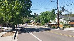 Campanile Drive | |
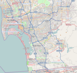 College Area, San Diego Location within San Diego | |
| Coordinates: 32°46′19″N 117°04′08″W / 32.771831°N 117.068939°W | |
| Country |
|
| State |
|
| County |
|
| City |
|
The College Area is a neighborhood of the Mid-City region of San Diego, California, United States. The College Area is dominated by San Diego State University (SDSU; once known as San Diego State College), after which the area is named. Several neighborhoods in the College Area were developed in the 1930s, with others becoming established in the post-war period.[1] The College Area is bordered on the west by Kensington and Talmadge and on the east by the city of La Mesa. El Cajon Boulevard is a busy shopping district; additional retail is in development near SDSU.
The College Area includes the neighborhoods of the Catoctin Area, Dennstedt Point, East Falls View Drive, Saranac-Mohawk, and an Orthodox Jewish neighborhood in the area near Congregation Beth Jacob Orthodox Synagogue on College Avenue. The region includes Alvarado Hospital, a 306-bed acute care facility, and the College-Rolando branch of the San Diego Public Library.
Geography
The college area lies on a plateau which overlooks Interstate 8. The neighborhood's borders are defined by Montezuma Road/Collwood Boulevard to the southwest, Interstate 8 to the north, 73rd Street to the east, and El Cajon Boulevard to the south.
Transportation
MTS (Metropolitan Transit System) operates the San Diego Trolley[2] to SDSU Transit Center and the Alvarado Medical Center trolley station, both of which are in the College Area. The trolley station at SDSU, as well as a bus plaza, make up the SDSU Transit Center. Bus routes 11, 11A, 14, 936, and Rapid Bus 215 go to the Transit Center, to name a few. Transfers are made from the SDSU trolley subway station located at the Transit Center, underneath the bus plaza. Riders can go up to the bus plaza via elevator or stairs.
As of October 12, 2014, the SDSU Transit Station serves as the starting point for MTS Rapid Bus Route 215. A high-frequency, limited-stop service runs between San Diego State University and Downtown San Diego via El Cajon Boulevard and Park Boulevard. This route provides a convenient transit option for visitors and nearby neighbors from downtown San Diego, North Park and Hillcrest to shop and dine in the busy commercial corridor.
All mass transit routes noted enable visitors from the San DIego region to explore San Diego State University's beautiful campus and enjoy the leisure, arts and culture provided by this institution of higher learning.
Traffic
The College Area is accessible from Interstate 8, State Route 94. Surface streets entering into the College Area include 70th Street (accessible from I-8), College Avenue (accessible from I-8 and SR94) and 54th Street and Montezuma Road (accessible from I-8). Built in July 2005 there is also a mass transit connection by MTS San Diego Trolley accessing the SDSU on-campus underground station. Traffic can be high during the day however, local residents and City officials working together to increase pedestrian and bicycle routes and modifying the street infrastructure to eleviate any congestion in the area as the population grows in the neighborhoods.
Education
The college area is home to one traditional elementary school, one private K-8 school, two alternative K-8 schools, and SDSU.
Elementary schools
K through 8
- Blessed Sacrament Parish School
K through 12
- San Diego Unified School District
- Language Academy
- Tubman Village Charter
Colleges and universities
References
- ↑ “Historical Neighborhoods.” College Neighborhoods, 2013. http://collegeneighborhoods.com/history/baja.html.
- ↑ Transit.511sd.com
External links
| Wikimedia Commons has media related to College Area, San Diego. |
- City Council District 9 Neighborhood: College Area
- College Area Community Council
- Alvarado Estates
- College View Estates
- Rolando Community Council
- Rolando Village, located in San Diego's college area, 92115
- College Neighborhoods Foundation
- Mission Times Courier, community newspaper
- College Area Business District
Coordinates: 32°46′18.59″N 117°4′8.18″W / 32.7718306°N 117.0689389°W