Leksvik
| Leksvik kommune | |||
|---|---|---|---|
| Former municipality | |||
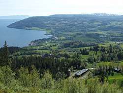 View of the village of Leksvik | |||
| |||
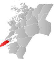 Leksvik within Nord-Trøndelag | |||
| Coordinates: 63°39′59″N 10°29′29″E / 63.66639°N 10.49139°ECoordinates: 63°39′59″N 10°29′29″E / 63.66639°N 10.49139°E | |||
| Country | Norway | ||
| County | Nord-Trøndelag | ||
| District | Fosen | ||
| Established | 1 Jan 1838 | ||
| Disestablished | 31 Dec 2017 | ||
| Administrative centre | Leksvik | ||
| Area | |||
| • Total | 430.22 km2 (166.11 sq mi) | ||
| • Land | 399.70 km2 (154.33 sq mi) | ||
| • Water | 30.52 km2 (11.78 sq mi) | ||
| Area rank | #230/426 in Norway | ||
| *Area at municipal dissolution. | |||
| Population (2017) | |||
| • Total | 3,480 | ||
| • Rank | #249/426 in Norway | ||
| • Density | 8.7/km2 (23/sq mi) | ||
| Demonym(s) | Leksværing[1] | ||
| Time zone | UTC+01:00 (CET) | ||
| • Summer (DST) | UTC+02:00 (CEST) | ||
| ISO 3166 code | NO-1718 | ||
| Official language form | Neutral | ||
| Created as | Formannskapsdistrikt in 1838 | ||
| Succeeded by | Indre Fosen in 2018 | ||

Leksvik is a former municipality in the old Nord-Trøndelag county (now in Trøndelag county), Norway. The administrative center of the municipality was the village of Leksvik. Other villages in Leksvik included Vanvikan, Seter, and Dalbygda. Norwegian County Road 755 is the main road that connected the whole municipality from north to south.

The villages of Leksvik and Vanvikan were the two largest urban areas in Leksvik, notable for their high tech industries which have developed to become advanced and in demand. Areas with agriculture were also widespread, but most of the municipality was covered in forests and mountains where the wildlife ruled with animals such as moose and reindeer. The moose are sometimes seen in the heart of Leksvik and Vanvikan, where modern downtown areas with commercial and residential developments are growing.
The 430-square-kilometre (170 sq mi) municipality was the 220th largest by area out of the then 426 municipalities in Norway at the time of its dissolution. Leksvik was the 249th most populous municipality in Norway with a population of 3,480. The municipality's population density was 8.7 inhabitants per square kilometre (23/sq mi) and its population had decreased by 0.1% over the last decade.[2]
General information
Leksvik was established as a municipality on 1 January 1838 (see formannskapsdistrikt). It was one of very few municipalities in Norway with unchanged borders since that date.[3]
The municipality of Leksvik was merged with the neighboring municipality of Rissa on 1 January 2018. The new municipality was named Indre Fosen and is located in the newly merged Trøndelag county.[4]
Name
The Old Norse form of the name was Lexuvík. The first element is the genitive case of a river name Lexa and the last element is vík which means "inlet". The river name is, maybe, derived from the word lax which means "salmon". The name has also, historically, been spelled Lexvigen or Leksviken.[5]
Coat of arms
The coat of arms were from modern times; they were granted on 28 September 1990 and they were used until 31 December 2017 when the municipality ceased to exist. The arms show the blue Trondheimsfjorden and a silver part representing the land with a clover at the end of it to represent life and growth.[6] The arms were adopted by the new municipality of Indre Fosen as well.
Churches
The Church of Norway had one parish (sokn) within the municipality of Leksvik. It was part of the Fosen prosti (deanery) in the Diocese of Nidaros.
| Parish (Sokn) | Church Name | Location of the Church | Year Built |
|---|---|---|---|
| Leksvik | Leksvik Church | Leksvik | 1670 |
| Stranda | Stranda Church | Vanvikan | 1897 |
Geography

Leksvik was located on the eastern side of the Fosen peninsula along the coast of Trondheimsfjorden. There are two large lakes located in Leksvik: Storvatnet and Meltingvatnet.
Government
The municipality of Leksvik was responsible for primary education (through 10th grade), outpatient health services, senior citizen services, unemployment and other social services, zoning, economic development, and municipal roads. The municipality was governed by a municipal council of elected representatives, which in turn elect a mayor.
Municipal council
The final municipal council (Kommunestyre) of Leksvik was made up of 25 representatives that are elected to four year terms. Currently, the party breakdown is as follows:[7]
| Party Name | Name in Norwegian | Number of representatives | |
|---|---|---|---|
| Labour Party | Arbeiderpartiet | 10 | |
| Progress Party | Fremskrittspartiet | 2 | |
| Conservative Party | Høyre | 5 | |
| Christian Democratic Party | Kristelig Folkeparti | 1 | |
| Centre Party | Senterpartiet | 5 | |
| Socialist Left Party | Sosialistisk Venstreparti | 1 | |
| Liberal Party | Venstre | 1 | |
| Total number of members: | 25 | ||
History
The first inhabitants are believed to have moved to Leksvik some 3,000 years ago. They left several pieces of cutting tools which are now placed in museums. But Leksvik does not appear in recorded history before the Viking Age when the villages Leksvik and Hindrem became quite important in the local area. In both Leksvik and Hindrem there have been found great tombs and ruins of buildings and longboats. On Borgen, there is a hill between Hindrem and Seter that may have been a great Viking fortress, but this could also be tracks made by the glaciers during the last ice age. After the Black Death struck Norway in 1349, Leksvik fell into silence for some 300 years.
In more modern history, Leksvik and Hindrem are small and relatively isolated villages, north of Trondheim Fjord. Two churches stood here, a church in Leksvik and a stave church in Hindrem, but this broke down in 1655 and was replaced by a modern wooden church. In the 19th century, the church of Hindrem was demolished, and the new Stranda Church was built in Vanvikan. Leksvik became well known for its goats and had 5,000 of them at their peak number.
During World War II, Leksvik was settled by German troops with the main camp on the top of Våttåhaugen, a hill north of the village of Leksvik. But as a small and isolated village, nothing of great importance happened there during the war, and it was mostly peaceful although bombs fell over Trondheim, on the south side of the fjord. After electric power first came to Leksvik, Bjørn Lyng founded the first industry in Vanvikan and Leksvik. After the first road was finally finished in the early 1960s, industry grew rapidly and replaced the goats.
Attractions
- Bjørnåa
- Borgen
- Leksvik Church
- Munken
- Stranda Church
- Våttåhaugen
References
- ↑ "Navn på steder og personer: Innbyggjarnamn" (in Norwegian). Språkrådet. Retrieved 2015-12-01.
- ↑ Statistisk sentralbyrå (2017). "Table: 06913: Population 1 January and population changes during the calendar year (M)" (in Norwegian). Retrieved 2017-10-01.
- ↑ Jukvam, Dag (1999). "Historisk oversikt over endringer i kommune- og fylkesinndelingen" (PDF) (in Norwegian). Statistisk sentralbyrå.
- ↑ "Om Indre Fosen" (in Norwegian). Indre Fosen kommune. Retrieved 2017-10-01.
- ↑ Rygh, Oluf (1903). Norske gaardnavne: Nordre Trondhjems amt (dokpro.uio.no) (in Norwegian) (15 ed.). Kristiania, Norge: W. C. Fabritius & sønners bogtrikkeri. p. 48.
- ↑ "Leksvik kommunevåpen" (in Norwegian). Leksvik kommune. Archived from the original on 2011-07-24. Retrieved 2008-11-02.
- ↑ "Table: 04813: Members of the local councils, by party/electoral list at the Municipal Council election (M)" (in Norwegian). Statistics Norway. 2015.
External links
| Wikimedia Commons has media related to Leksvik. |

- Webcam showing the view from Leksvik in the direction of Frosta
- European ash north to Leksvik
| Authority control |
|---|