Coalcliff, New South Wales
| Coalcliff Wollongong, New South Wales | |||||||||||||||
|---|---|---|---|---|---|---|---|---|---|---|---|---|---|---|---|
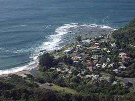 View of Coalcliff from the Illawarra Escarpment | |||||||||||||||
|
Coalcliff | |||||||||||||||
| Coordinates | 34°14′S 150°58′E / 34.233°S 150.967°ECoordinates: 34°14′S 150°58′E / 34.233°S 150.967°E[1] | ||||||||||||||
| Population | 189 (2016 census)[2] | ||||||||||||||
| Postcode(s) | 2508 | ||||||||||||||
| LGA(s) | City of Wollongong | ||||||||||||||
| State electorate(s) | Heathcote | ||||||||||||||
| Federal Division(s) | Cunningham | ||||||||||||||
| |||||||||||||||
Coalcliff is a town on the coast of New South Wales, Australia, between Sydney and Wollongong. Together with Stanwell Park it belongs to the Little Bulli indentation of the northern Illawarra coast strip.
History
In 1796 William Clark and others trekking north to Port Jackson from the wrecked ship Sydney Cove noticed coal exposed at the cliffs there and made a fire from it, attracting rescuers, giving the area its name.[3] George Bass was despatched to report on it and traced the deposit along the shore and inland.[4] There was nowhere for ships to safely land though, so it was not until 1850 that it began to be excavated.
In 1888 the Coalcliff General Store opened at 28 Paterson Road (once referred to as the 'main street') by Mr John Earle Gibbons and his wife, son and daughter-in-law of Matthew John Gibbons who arrived in Australia in 1790 as a convict on the Second Fleet, and was one of Coalcliff's earliest residents. Architecturally the store was of plain colonial style, constructed of local wood with a sandstone foundation. It sold, amongst other household items, Milk, Bread, Butter, Drinks, Meat, Stationary goods, Cigarettes and other tobacco paraphernalia, jams, preserves, poultry and bakery products. The shop was the major lifeforce behind the township until closure in 1907. The same year the shops was burned to the ground via unknown causes and remained a vacant lot until 1910 when another store was erected and opened by a Mr. L. Jameson. This is the building that still stands today at the corner on Paterson Road, which has been a private residential property since 1961.
The Jameson Store was the last running commercial outlet in Coalcliff, which ceased operation in May 1960 due to an overexpense of running costs and a severe lack of customers, with many of the towns-people opting to shop at nearby Stanwell Park, Helensburgh or south to Bulli and Woollongong. At the height of its popularity it served as a Milkbar, Fish & Chip shop, General Store, Tobacconist and even a small Bottle shop within its small boundaries. Its unsurpassable views meant it was a popular place for holidayers passing by.
The only evidence of this once thriving store are the fading advertisements painted to its side and roof.
Attractions
The Sea Cliff Bridge was opened on 11 December 2005 and offers a spectacular walkway and cycleway above the ocean and along the escarpment. There are splendid views offered towards Wollongong and Port Kembla in the south and Bald Hill and the Royal National Park in the north.
This also forms part of The Grand Pacific Walk which is currently being constructed through Coalcliff.
The Wodi Wodi Track can be accessed on Lawrence Hargrave Drive at the northern end of Coalcliff.
Coalcliff beach offers great surfing conditions and an ocean pool. Access to the pool from Lawrence Hargrave Drive is through Leeder Park, named after Noel Leeder who was a Manager at the Coalcliff Cokeworks in the 1960s and ensured the park be established.
There are public toilets and showers in Leeder Park and at the surf club.
Activities
Coalcliff hosts its own Surf Life Saving Club with events like Nippers in summertime and assuring beach safety. The Sea Eals winter swimming club takes place in the ocean pool and is co-organised with the Helensburgh-Stanwell Park Surf Life Saving Club such as the yearly 2.4 km Ocean Challenge swim between the two clubs in early April.
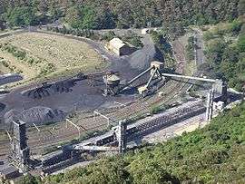
Industry
Coalcliff hosted the Illawarra Coke Company (ICC) until it was shutdown in recent years. The Cokeworks here and at Corrimal produced approximately 250,000 tonnes of coke per annum using non-recovery technology.
References
- ↑ Coalcliff page at Geoscience Australia
- ↑ Australian Bureau of Statistics (27 June 2017). "Coalcliff (State Suburb)". 2016 Census QuickStats. Retrieved 16 July 2017.

- ↑ "PLACE NAMES". The Australian Women's Weekly. 13 May 1964. p. 61. Retrieved 22 February 2011 – via National Library of Australia.
- ↑ Miriam Estensen, The Life of George Bass, Allen and Unwin, 2005, ISBN 1-74114-130-3, page 72
External links
- "Illawarra Coal" – An unofficial history of coal mining in the Illawarra
- Coalcliff Surf Life Saving Club
- Coalcliff Community Web Portal
- Illawarra Coke Company - web site