Coal Creek, Washington
| Coal Creek, Washington | |
|---|---|
| Unincorporated community | |
 Coal Creek Location in the state of Washington  Coal Creek Coal Creek (the US) | |
| Coordinates: 46°12′00″N 123°01′00″W / 46.20000°N 123.01667°WCoordinates: 46°12′00″N 123°01′00″W / 46.20000°N 123.01667°W | |
| Country |
|
| State |
|
| County | Cowlitz |
| Elevation[1] | 69 m (226 ft) |
| Time zone | UTC−8 (PST) |
| • Summer (DST) | UTC−7 (PDT) |
| ZIP code | 98632 |
| Area code(s) | 360 |
| FIPS code | 53-13435 |
| GNIS feature ID | 1512102 |
Coal Creek is an unincorporated community in Cowlitz County, Washington. Coal Creek is located northwest of the city of Longview, reached by traveling westbound out of the city along Washington State Route 4, also known as Ocean Beach Highway, and turning north onto Coal Creek Road. The Coal Creek community is part of the Longview School District, a K-12 school district of about 6,600 students.
Geography
Coal Creek is located at 46°12′00″N 123°01′00″W / 46.20000°N 123.01667°W (46.2001109, -123.0167817).[2]
External links
References
- ↑ "USGS—Coal Creek, Washington". Retrieved 13 June 2014.
- ↑ "2013 U.S. Gazetteer Files". census.gov. Retrieved 13 June 2014.
Municipalities and communities of Cowlitz County, Washington, United States | ||
|---|---|---|
| Cities | 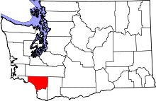 | |
| CDPs | ||
| Unincorporated communities |
| |
| Footnotes | ‡This populated place also has portions in an adjacent county or counties | |
This article is issued from
Wikipedia.
The text is licensed under Creative Commons - Attribution - Sharealike.
Additional terms may apply for the media files.