Carrolls, Washington
| Carrolls, Washington | |
|---|---|
| Unincorporated community | |
 Carrolls Location in the state of Washington  Carrolls Carrolls (the US) | |
| Coordinates: 46°04′17″N 122°51′44″W / 46.07139°N 122.86222°WCoordinates: 46°04′17″N 122°51′44″W / 46.07139°N 122.86222°W | |
| Country |
|
| State |
|
| County | Cowlitz |
| Elevation[1] | 21 m (69 ft) |
| Time zone | UTC−8 (PST) |
| • Summer (DST) | UTC−7 (PDT) |
| ZIP code | 98626 or 98609 (Carrolls has its own Post Office) |
| Area code(s) | 360 |
| FIPS code | 53-10285 |
| GNIS feature ID | 1512067 |
Carrolls is an unincorporated community in Cowlitz County, Washington, south of the city of Kelso. Carrolls is located south on Old Pacific Highway from exit 36 of Interstate 5. The Carrolls community is part of the Kelso School District, a K-12 school district of nearly 5,000 students.
The community derives its name one Major Carroll, a pioneer resident.[2]
Geography
Carrolls is located at 46°04′17″N 122°51′44″W / 46.07139°N 122.86222°W (46.0715022, -122.8623306).[3]
External links
References
- ↑ "USGS—Carrolls, Washington". Retrieved 12 June 2014.
- ↑ Meany, Edmond S. (1923). Origin of Washington geographic names. Seattle: University of Washington Press. p. 37.
- ↑ "2013 U.S. Gazetteer Files". census.gov. Retrieved 12 June 2014.
Municipalities and communities of Cowlitz County, Washington, United States | ||
|---|---|---|
| Cities | 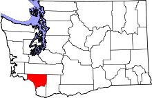 | |
| CDPs | ||
| Unincorporated communities |
| |
| Footnotes | ‡This populated place also has portions in an adjacent county or counties | |
This article is issued from
Wikipedia.
The text is licensed under Creative Commons - Attribution - Sharealike.
Additional terms may apply for the media files.