Claymont, Delaware
| Claymont, Delaware | |
|---|---|
| CDP | |
 | |
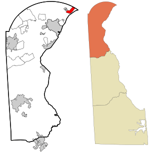 Location in New Castle County and the state of Delaware. | |
 Claymont Location within the state of Delaware  Claymont Claymont (the US) | |
| Coordinates: 39°48′02″N 75°27′35″W / 39.80056°N 75.45972°WCoordinates: 39°48′02″N 75°27′35″W / 39.80056°N 75.45972°W | |
| Country | United States |
| State | Delaware |
| County | New Castle County |
| First settled | before 1200 |
| Renamed | 1856 |
| Area | |
| • Total | 2.1 sq mi (5.5 km2) |
| • Land | 2.1 sq mi (5.5 km2) |
| • Water | 0.0 sq mi (0.0 km2) |
| Elevation | 75 ft (23 m) |
| Population (2010) | |
| • Total | 8,253 |
| • Density | 3,930.0/sq mi (1,500.5/km2) |
| Time zone | UTC-5 (Eastern (EST)) |
| • Summer (DST) | UTC-4 (EDT) |
| ZIP code | 19703 |
| Area code(s) | 302 |
| FIPS code | 10-15310 |
| GNIS feature ID | 213804[1] |
| Website | claymontrenaissance.org |
Claymont is a census-designated place (CDP) in New Castle County, Delaware, United States. The population was 8,253 at the 2010 census.
History
Claymont has been a continuous settlement near the mouth of Naamans Creek on the Delaware River since at least A.D. 1200, with evidence of its original inhabitants along both banks pointing to the Middle Woodland period (1100-1600 B.C.). The first western inhabitants named the creek and settlement after the Lenape chief who occupied the region.[2]
In 1681, John Grubb purchased a one-third interest in a 600-acre tract of the Brandywine Hundred which came to be known as Grubb's Landing.[3]
During the colonial period, the town served as a stop along the King's Highway, and with its location at the confluence of Interstate 95, Interstate 495, US 13 (Governor Printz Boulevard) and US 13 Bus. (Philadelphia Pike), has long been a thoroughfare for travel between Philadelphia (20 miles to the north) and Washington, D.C. (100 miles to the south).
Claymont was so-named in 1856 upon the efforts of the wife of Reverend Clemson, pastor of the Episcopal church, after they had relocated from their family plantation, Claymont Court, in Charles Town, West Virginia.[4]
The area developed from a primarily agricultural community in the mid-19th century into a suburban resort area for wealthy Philadelphia families, and in the early 20th century into an industrial working community.[5]
Renaissance
Since 1993, several major revitalization efforts have been completed, including renovations of historical sites such as the Claymont Stone School, the Darley House and the Robinson House. The Claymont Renaissance Development Corporation, a nonprofit organization working to stimulate economic growth and residential improvement in Claymont, received a Sustainable Communities Award from the National Association of Counties.[6][7] In what has been called "the single largest redevelopment project in Brandywine Hundred in the last 40 years", the 633-unit, 66-acre (270,000 m2) community of Brookview was razed beginning in 2007 to make way for Renaissance Village.[8] In addition to the Claymont Stone School, the Darley House and the Robinson House, the Archmere Academy, Hickman Row, and Ivyside Farm are listed on the National Register of Historic Places.[9]
Geography
Claymont is located at 39°48′02″N 75°27′35″W / 39.80056°N 75.45972°W (39.8006685, -75.4596404),[10] in northeastern Brandywine Hundred, on the ridge line between the coastal floodplain of the Delaware River and the upland piedmont area of northwestern New Castle County.
According to the United States Census Bureau, the CDP has a total area of 2.1 square miles (5.4 km2), all land. The area generally considered to be Claymont encompasses the entire 19703 ZIP code,[5] which is bounded by the Pennsylvania border to the north, the Delaware River to the east, the CSX railroad line to the west, and Perkins Run to the south.[11]
Demographics
| Historical population | |||
|---|---|---|---|
| Census | Pop. | %± | |
| 1970 | 6,584 | — | |
| 1980 | 10,022 | 52.2% | |
| 1990 | 9,800 | −2.2% | |
| 2000 | 9,220 | −5.9% | |
| 2010 | 8,253 | −10.5% | |
| source:[12] | |||
As of the census[13] of 2000, there were 9,220 people, 3,792 households, and 2,400 families residing in the CDP. The population density was 4,371.4 people per square mile (1,687.1/km²). There were 4,193 housing units at an average density of 1,988.0 per square mile (767.3/km²). The racial makeup of the CDP was 71.04% White, 23.33% African American, 0.33% Native American, 1.44% Asian, 0.02% Pacific Islander, 1.63% from other races, and 2.21% from two or more races. Hispanic or Latino of any race were 4.18% of the population.
There were 3,792 households out of which 32.5% had children under the age of 18 living with them, 40.6% were married couples living together, 17.2% had a female householder with no husband present, and 36.7% were non-families. 30.6% of all households were made up of individuals and 9.5% had someone living alone who was 65 years of age or older. The average household size was 2.42 and the average family size was 3.01.
In the CDP, the population was spread out with 26.4% under the age of 18, 8.5% from 18 to 24, 34.0% from 25 to 44, 19.0% from 45 to 64, and 12.1% who were 65 years of age or older. The median age was 35 years. For every 100 females, there were 89.9 males. For every 100 females age 18 and over, there were 86.9 males.
The median income for a household in the CDP was $40,813, and the median income for a family was $46,780. Males had a median income of $36,493 versus $28,399 for females. The per capita income for the CDP was $20,211. About 6.6% of families and 7.2% of the population were below the poverty line, including 10.4% of those under age 18 and 3.0% of those age 65 or over.
The ZIP Code Tabulation Area for 19703 includes communities such as Ashbourne Hills, the Greentree section, the Society Hill Section, and parts of Rolling Park, which are not included in Claymont CDP, and had a population of 15,312 at the 2000 census.[13]
Transportation
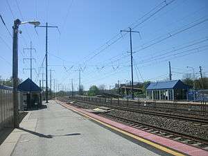
Major roads that serve Claymont include Interstate 95, Interstate 495, US 13 (Governor Printz Boulevard), US 13 Bus. (Philadelphia Pike), and DE 92 (Naamans Road).[14] Claymont Station is a SEPTA Regional Rail train station on the Wilmington/Newark Line, providing service north to Center City Philadelphia and south to Wilmington and Newark.[15] Trains along Amtrak's Northeast Corridor pass through Claymont but do not stop; the nearest Amtrak station is Wilmington Station.[14] DART First State provides bus service to Claymont along Route 13, which runs from the Tri-State Mall in Claymont south along Philadelphia Pike to Wilmington and the Walmart on Wilton Boulevard near New Castle; Route 31, which runs from the Claymont Station south along Philadelphia Pike to Wilmington; and Route 61, which runs from the Claymont Station west along Naamans Road to the Brandywine Town Center and the Concord Mall.[16] SEPTA Suburban Bus Route 113 runs from the Tri-State Mall in Claymont north into Delaware County, Pennsylvania, providing service to the Chester Transportation Center in Chester, the Darby Transportation Center in Darby, and the 69th Street Transportation Center in Upper Darby.[17]
Places of interest
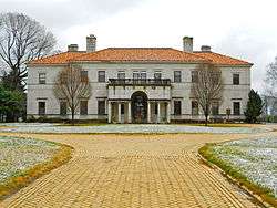
Claymont is home to several historic places, including the Claymont Stone School (which may have been the state's first racially integrated public school), Archmere Academy (in the former home of industrialist John J. Raskob), the Darley House (former home of illustrator F. O. C. Darley), and the Robinson House (with a Block House believed to be the only structure remaining of the original Naaman's Creek settlement). It is also the headquarters of several prominent businesses, including Evraz Claymont Steel and CIGNA Global Health Benefits. Fortune 500 metals and mining giant, Minmetals, has a presence in Claymont as the owners of the Holiday Inn Select Hotel on Naamans Road.
Notable people
- Valerie Bertinelli, One Day at a Time and Touched by an Angel actress
- Joe Biden, U. S. Senator and Vice President
- J. Caleb Boggs, Governor of Delaware, U. S. Representative, and U. S. Senator
- F. O. C. Darley, known as "Father of American Illustration"
- John Grubb, two-term member of the Pennsylvania Provincial Assembly, one of the original settlers of Claymont
- Nathaniel Grubb, served in the Pennsylvania Colonial Assembly
- John J. Raskob, DuPont and General Motors executive
- Adolf Ulric Wertmüller, Swedish portrait painter
References
- ↑ "Claymont". Geographic Names Information System. United States Geological Survey.
- ↑ Ferris, Benjamin (1846). A History of the Original Settlements on the Delaware. Wilimington: Wilson and Healde. p. 134. Retrieved 22 June 2017.
- ↑ "Grubb Family Papers". www.lib.udel.edu. Retrieved 9 December 2017.
- ↑ Claymont Historical Society Archived 2008-09-11 at the Wayback Machine.
- 1 2 Claymont Community Redevelopment Plan Archived 2008-07-06 at the Wayback Machine.
- ↑ "2005 Awards Program Publication" (PDF).
- ↑ "Claymont Renaissance: Community revitalization gets national attention" (PDF). Living and Working in New Castle County. Journal Communications Inc.
- ↑ "Demolition of Brookview Townhomes Begins" (PDF). Brandywine Community News. 2007-11-23.
- ↑ National Park Service (2010-07-09). "National Register Information System". National Register of Historic Places. National Park Service.
- ↑ "US Gazetteer files: 2010, 2000, and 1990". United States Census Bureau. 2011-02-12. Retrieved 2011-04-23.
- ↑ Claymont boundary map Archived 2008-08-06 at the Wayback Machine.
- ↑ "CENSUS OF POPULATION AND HOUSING (1790-2000)". U.S. Census Bureau. Retrieved 2010-07-17.
- 1 2 "American FactFinder". United States Census Bureau. Archived from the original on 2013-09-11. Retrieved 2008-01-31.
- 1 2 Delaware Department of Transportation (2008). Delaware Official Transportation Map (PDF) (Map). Dover: Delaware Department of Transportation.
- ↑ "Wilmington/Newark Line schedule" (PDF). SEPTA. Retrieved December 26, 2017.
- ↑ "Routes and Schedules". DART First State. Retrieved August 16, 2013.
- ↑ "Route 113 bus schedule" (PDF). SEPTA. Retrieved December 26, 2017.
External links
| Wikivoyage has a travel guide for Claymont. |
- Claymont Renaissance Development Corporation
- The story of the Claymont Christmas Weed
- 2006 Claymont Christmas Parade Highlights
- Steel Making in Claymont, Delaware
