Claylick, Pennsylvania
| Claylick, Pennsylvania | |
|---|---|
| Unincorporated community | |
 Claylick  Claylick | |
| Coordinates: 39°46′0″N 77°53′37″W / 39.76667°N 77.89361°WCoordinates: 39°46′0″N 77°53′37″W / 39.76667°N 77.89361°W | |
| Country | United States |
| State | Pennsylvania |
| County | Franklin |
| Township | Montgomery |
| Elevation | 518 ft (158 m) |
| Time zone | UTC-5 (Eastern (EST)) |
| • Summer (DST) | UTC-4 (EDT) |
| ZIP code | 17236 |
| Area code(s) | 717 |
| GNIS feature ID | 1171950[1] |
Claylick is an unincorporated community in Montgomery Township in Franklin County, Pennsylvania, United States. Claylick is located at the intersection of Pennsylvania Route 75 and Pennsylvania Route 995 south of Mercersburg.[2]
Clay Lick was laid out about 1831, and named after nearby Clay Lick Mountain.[3] A post office called Clay Lick was established in 1862, the name was changed to Claylick in 1895, and the post office closed in 1905.[4]
References
- ↑ "Claylick". Geographic Names Information System. United States Geological Survey.
- ↑ Franklin County, Pennsylvania Highway Map (PDF) (Map). PennDOT. 2015. Retrieved January 2, 2016.
- ↑ M'Cauley, I. H. (1878). Historical Sketch of Franklin County, Pennsylvania. Patriot. p. 206.
- ↑ "Franklin County". Jim Forte Postal History. Retrieved 19 June 2017.
Municipalities and communities of Franklin County, Pennsylvania, United States | ||
|---|---|---|
| Boroughs | 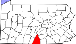 | |
| Townships | ||
| CDPs | ||
| Unincorporated communities |
| |
| Footnotes | ‡This populated place also has portions in an adjacent county or counties | |
This article is issued from
Wikipedia.
The text is licensed under Creative Commons - Attribution - Sharealike.
Additional terms may apply for the media files.