Clay, Wisconsin
| Clay, Wisconsin | |
|---|---|
| Ghost town | |
 Clay, Wisconsin | |
| Coordinates: 44°23′46″N 90°40′50″W / 44.39611°N 90.68056°WCoordinates: 44°23′46″N 90°40′50″W / 44.39611°N 90.68056°W | |
| Country | United States |
| State | Wisconsin |
| County | Jackson |
| Elevation | 932 ft (284 m) |
| GNIS feature ID | 2741956[1] |
Clay is a ghost town in the town of Komensky, Jackson County, Wisconsin, United States.[1] The community is still marked on Wisconsin Department of Transportation maps.[2]
Notes
- 1 2 "Clay (historical), Wisconsin". Geographic Names Information System. United States Geological Survey.
- ↑ Jackson County (PDF) (Map). Wisconsin Department of Transportation. 2012. Archived from the original (PDF) on July 21, 2011. Retrieved October 25, 2012.
Municipalities and communities of Jackson County, Wisconsin, United States | ||
|---|---|---|
| City | 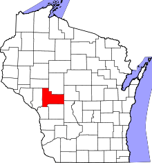 | |
| Villages | ||
| Towns | ||
| CDPs | ||
| Unincorporated communities | ||
| Ghost towns/neighborhoods | ||
| Indian reservation | ||
| Footnotes | ‡This populated place also has portions in an adjacent county or counties | |
This article is issued from
Wikipedia.
The text is licensed under Creative Commons - Attribution - Sharealike.
Additional terms may apply for the media files.