Clarkston, East Renfrewshire
Clarkston
| |
|---|---|
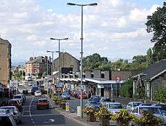 Busby Road, Clarkston's main shopping street | |
| Population | 14,944 [1] |
| OS grid reference | NS565565 |
| • Edinburgh | 50 mi (80 km) ENE |
| • London | 343 mi (552 km) SSE |
| Lieutenancy area | |
| Country | Scotland |
| Sovereign state | United Kingdom |
| Post town | GLASGOW |
| Postcode district | G76 |
| Dialling code | 0141 |
| Police | Scottish |
| Fire | Scottish |
| Ambulance | Scottish |
| EU Parliament | Scotland |
| UK Parliament | |
| Scottish Parliament | |
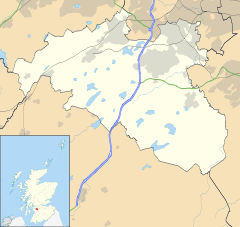
Clarkston (Scots: Clairkstoun, Scottish Gaelic: Baile Chlarc) is a suburban town in East Renfrewshire, in the Central Lowlands of Scotland. It lies 4.7 miles (7.6 km) east of Barrhead, 7.2 miles (11.6 km) east-southeast of Paisley and 3.9 miles (6.3 km) northwest of East Kilbride. A small dormitory town with a population of 14,944, Clarkston is on the southern fringe of the Greater Glasgow conurbation and directly adjoins the neighbouring suburbs of Busby, Giffnock and Stamperland.
On 21 October 1971, the shopping centre was the scene of the Clarkston explosion, which killed 22 people and injured around 100. A plaque on the site commemorates the event.
Greenbank Garden, a National Trust for Scotland property, is located on the outskirts of Clarkston.
History
When a new road from Paisley to East Kilbride was built through the area in the 1790s, a toll point was set up where it crossed what was then the main route from Glasgow to Kilmarnock. A man named John Clark built a house at the toll, and the name 'Clarkston' came to be used for the locality.[2][3] The Maxwell family (owners of the Williamwood Estate, on which Clarkston was situated) advertised the creation of a new village there in 1801, but initially it grew slowly. Clarkston at this time had no industry of its own, and villagers were mainly employed in the mills at nearby Netherlee.[2][3]
The area began to expand more rapidly following the opening of Clarkston railway station by Busby Railways in the village in 1866,[4] and later the expansion of the Glasgow tram network to Clarkston in 1921.[5] The 1920s also saw the final breaking up of the Williamwood Estate, encouraging further house building.[2] Clarkston expanded rapidly as new suburban housing developments sprang up such as Williamwood, Carolside and Overlee.[6]
Governance
Clarkston is in East Renfrewshire, one of the 32 council areas of Scotland for local government purposes. East Renfrewshire Council, the unitary local council, is based in nearby Giffnock and is the body responsible for local governance. For local electoral purposes, Clarkson was formerly a ward electing a single councillor to East Renfrewshire Council, but is now grouped with Busby and Eaglesham as a larger multi-member ward electing three councillors.[7] Clarkston is one of East Renfrewshire's designated community council areas, but following the dissolution of the previous community council in 2015 there were insufficient nominations for it to be re-established at that time.[8]
The Scottish Parliament is responsible for devolved matters such as education, health and justice,[9] while reserved matters are dealt with by the Parliament of the United Kingdom. Clarkston forms part of the county constituency of East Renfrewshire, electing one member of parliament (MP) to the House of Commons of the Parliament of the United Kingdom. Kirsten Oswald of the SNP was elected as MP for East Renfrewshire in the 2015 General Election. Before the constituency's creation in 2005, Clarkston lay in the Eastwood Constituency. For the purposes of the Scottish Parliament, Clarkston forms part of the Eastwood constituency, which is represented by Jackson Carlaw MSP, of the Conservative party.
Geography
Places adjacent to Clarkston, East Renfrewshire | ||||||||||
|---|---|---|---|---|---|---|---|---|---|---|
| ||||||||||
| Paisley | ||||||||||||||||||||||||||||||||||||||||||||||||||||||||||||
|---|---|---|---|---|---|---|---|---|---|---|---|---|---|---|---|---|---|---|---|---|---|---|---|---|---|---|---|---|---|---|---|---|---|---|---|---|---|---|---|---|---|---|---|---|---|---|---|---|---|---|---|---|---|---|---|---|---|---|---|---|
| Climate chart (explanation) | ||||||||||||||||||||||||||||||||||||||||||||||||||||||||||||
| ||||||||||||||||||||||||||||||||||||||||||||||||||||||||||||
| ||||||||||||||||||||||||||||||||||||||||||||||||||||||||||||
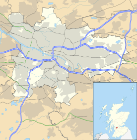
At 55°47′9″N 4°16′32″W / 55.78583°N 4.27556°W (55.785°, −4.276°) Clarkston is situated in Scotland's Central Lowlands. The community lies 4.7 miles (7.6 km) east of Barrhead, 3.9 miles (6.3 km) northwest of East Kilbride and 5.57 miles (9.0 km) south of Glasgow. The territory of Clarkston is contiguous with Glasgow and forms part of Greater Glasgow, the United Kingdom's fifth largest conurbation.
Clarkston experiences a temperate maritime climate, like much of the British Isles, with relatively cool summers and mild winters. Regular but generally light precipitation occurs throughout the year.[10]
Clarkston is a postal district within the post town of Glasgow in the G postcode area. Clarkston consists of postcode district G76, which also extends beyond the town boundary to include neighbouring settlements Busby, Carmunnock, Eaglesham and Waterfoot.
Demography
| Clarkston | East Renfrewshire | Scotland | |
|---|---|---|---|
| Total population | 14,944 | 89,311 | 5,062,011 |
| Foreign born | 2.9% | 3.8% | 3.8% |
| Over 75 years old | 7.12% | 6.9% | 7.1% |
| Unemployed | 1.9% | 2.5% | 3.9% |
According to the United Kingdom Census 2001, the census locality (town and sub-area) of Clarkston had a total resident population of 19,944, or 21% of the total of East Renfrewshire.[1] The median age of males and females living in Clarkston was 38 and 41 respectively, compared to 37 and 39 years for those in the whole of Scotland.[1] Fifty nine percent were married, 3.7% were cohabiting couples, 7.0% were lone parent families and 23.2% of households were made up of individuals.[1][12]
The place of birth of the towns residents was 97.1% United Kingdom (including 91.8% from Scotland), 0.5% Republic of Ireland, 0.5% from other European Union countries and 1.9% from elsewhere in the world.[1] Compared with the average demography of Scotland, Clarkston has higher proportions of people born in Scotland and young children (0–15 years old).[1]
Of residents 16–74, 44.0% were in full-time employment, 13.1% in part-time employment, 7.2% self-employed and 1.9% unemployed compared with Scotland as a whole which has 40.3%, 11.1%, 6.6% and 4% respectively. Additionally, in Clarkston 4.5% students have jobs while 4.2% do not, 15.4% are retired, 4.8% look after their home or family, 3.0% are permanently sick or disabled, and 1.9% are economically inactive for other reasons.[13]
Landmarks
Greenbank Garden is a National Trust for Scotland property situated on Flenders Road, consisting of the 18th century Greenbank House and its walled gardens. The house is a Category A listed building.
Transport
The area has a number of high-volume road links to neighbouring Glasgow. The A77 main Glasgow to Kilmarnock road passes through the Giffnock nearby and is connected to the A727 from Paisley to East Kilbride, which passes through the centre of Clarkston, at the Eastwood Toll. The nearest motorway is the M77, of which Junction 3 at Darnley is the interchange for Clarkston.
Clarkston lies within the Strathclyde Partnership for Transport Passenger transport executive and is served by two railway stations, both of which are managed by Abellio ScotRail:[14][15]
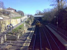
- Clarkston railway station, opened on 1 January 1866 [16] lies on the East Kilbride branch of the Glasgow South Western Line, which runs from Glasgow Central 5 miles (8.0 km) north.
- Williamwood railway station, opened on 9 July 1929,[17] lies on the Neilston branch of the Cathcart Circle 4.7 miles (7.6 km) south-southwest of Glasgow Central.
The closest airport is Glasgow Airport, 8.1 miles (13.0 km) northwest of Clarkston.
Clarkston is serviced by a number of bus routes by various operators. The main bus links are the number 4, linking nearby Eaglesham or Newton Mearns with the city centre and Knightswood, and the number 6, which connects East Kilbride with Clydebank. Both services are operated by First Glasgow.
Notable people
Pop musicians associated with Clarkston include former Thin Lizzy and Motörhead guitarist Brian "Robbo" Robertson who was born and grew up locally,[18] and Stuart Murdoch of Belle and Sebastian, who also grew up in the area.[19]
Novelist Alistair MacLean lived in the area before moving to Switzerland as a tax exile.[20]
Public services
Clarkston forms part of the Western water and sewerage regions of Scotland. Waste management is provided by the East Renfrewshire local council. Water supplies are provided by Scottish Water, a government-owned corporation of the Scottish Government. Clarkston's Distribution Network Operator for electricity is Scottish Power.[21] The NHS board is NHS Greater Glasgow and Clyde. The Scottish Fire and Rescue Service is the statutory fire and rescue service and has a fire station based in Clarkson.[22]
Policing in Clarkston is provided by Police Scotland. The Strathclyde Partnership for Transport, a public body in Scotland, has direct operational responsibilities, such as supporting (and in some cases running) local bus services and managing integrated ticketing in Clarkston and other areas from the former Strathclyde region.[23] Transport Scotland manages the local rail network.[23]
References
- 1 2 3 4 5 6 7 "Comparative Population Profile: Clarkston Locality, Scotland". scrol.gov.uk. 2001. Retrieved 2013-05-24.
- 1 2 3 Nisbet 2007, p. 4.
- 1 2 Nisbet 2007, p. 34.
- ↑ Nisbet 2007, p. 38.
- ↑ Nisbet 2007, p. 24.
- ↑ Nisbet 2007, pp. 26-27.
- ↑ "Councillors and democracy". East Renfrewshire Council. Retrieved 22 June 2016.
- ↑ Loney, Gillian (15 September 2015). "East Ren community councils feud continues". Glasgow South and Eastwood Extra. Retrieved 22 June 2016.
- ↑ "Reserved and devolved matters". Scotland Office. Archived from the original on 4 October 2006. Retrieved 2012-12-19.
- ↑ "Paisley 1981–2010 averages". 1981–2010 averages. Met Office. Retrieved 3 April 2013.
- ↑ "Comparative Population Profile: East Renfrewshire Council Area, Scotland". scrol.gov.uk. 2001. Retrieved 2012-12-19.
- ↑ "Comparative Household Profile: Clarkston Locality, Scotland". scrol.gov.uk. 2001. Retrieved 2013-05-24.
- ↑ "Comparative Employment Profile: Clarkston Locality, Scotland". scrol.gov.uk. 2001. Retrieved 2012-12-19.
- ↑ National Rail (23 January 2007). "Station Facilities: Clarkston (CKS)". nationalrail.co.uk. Retrieved 2013-05-24.
- ↑ National Rail (23 January 2007). "Station Facilities: Williamwood (WLM)". nationalrail.co.uk. Retrieved 2013-05-24.
- ↑ Butt (1995), page 62
- ↑ Butt (1995), page 251
- ↑ Eastwood High School Achievers
- ↑ "Enjoying a Belle epoch". The Scotsman. Edinburgh. 22 February 2002. Retrieved 8 November 2015.
- ↑ Overview of Alistair MacLean.Gazetteer of Scotland.Accessed on 12 November 2008
- ↑ "Electricity Distribution Network Operators". energylinx.co.uk. 2007. Retrieved 2013-03-31.
- ↑ "Fire Station Search". Scottish Fire and Rescue Service. Retrieved 22 June 2016.
- 1 2 Strathclyde Partnership for Transport (5 September 2007). "Who we are". spt.co.uk. Archived from the original on 8 April 2008. Retrieved 2008-02-11.
Sources
- Nisbet, Douglas (2007). Old Clarkston and Netherlee. Catrine: Stenlake.
- Butt, R. V. J. (1995). The Directory of Railway Stations: details every public and private passenger station, halt, platform and stopping place, past and present (1st ed.). Sparkford: Patrick Stephens Ltd. ISBN 978-1-85260-508-7. OCLC 60251199.
External links
![]()