Litchfield, Quebec
| Litchfield | |
|---|---|
| Municipality | |
 | |
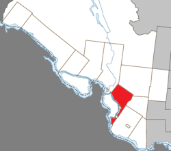 Location within Pontiac RCM. | |
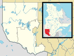 Litchfield Location in western Quebec. | |
| Coordinates: 45°45′N 76°35′W / 45.750°N 76.583°WCoordinates: 45°45′N 76°35′W / 45.750°N 76.583°W[1] | |
| Country |
|
| Province |
|
| Region | Outaouais |
| RCM | Pontiac |
| Constituted | July 1, 1855 |
| Government[2] | |
| • Mayor | Colleen Larivière |
| • Federal riding | Pontiac |
| • Prov. riding | Pontiac |
| Area[2][3] | |
| • Total | 214.10 km2 (82.66 sq mi) |
| • Land | 202.63 km2 (78.24 sq mi) |
| Population (2011)[3] | |
| • Total | 456 |
| • Density | 2.3/km2 (6/sq mi) |
| • Pop 2006-2011 |
|
| • Dwellings | 229 |
| Time zone | UTC−5 (EST) |
| • Summer (DST) | UTC−4 (EDT) |
| Postal code(s) | J0X 1K0 |
| Area code(s) | 819 |
| Highways |
|
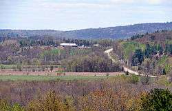
Litchfield is a municipality in the Outaouais region, part of the Pontiac Regional County Municipality, Quebec, Canada. It is located on the shores of the eastern channel of the Ottawa River at Calumet Island.
Its settlements include Vinton (once known as St-Elizabeth-de-Franktown[4]) and Goldwin. Notable lakes include Litchfield, Leslie, and Ours (Bear) Lakes.
History
Litchfield Township, spelled "Licthfield" on the Gale and Duberger map of 1795, was officially created in 1834. It was probably named after Lichfield, an English town in Staffordshire, north of Birmingham.[5] On November 20, 1846, the township was incorporated with Alfred Lancaster as its first mayor.[4] It was abolished the next year and became part of the Ottawa County Municipality. It was reestablished in 1855.[5]
In 1863, the Municipality of Portage-du-Fort Village separated from Litchfield's territory,[6] followed by Bryson in 1873, and by Campbell's Bay in 1904.[5] Because Bryson was located in the narrowest part of the municipality, between L'Île-du-Grand-Calumet and Clarendon, it separated the municipality's territory in two.
In 1964, the Pontiac County Council (now Pontiac MRC) built its headquarters in Litchfield on Quebec Route 148 at the edge of Campbell's Bay.[4]
On November 6, 2004, the Township Municipality of Litchfield changed its status and became the Municipality of Litchfield.[5]
Demographics
Population
| Canada census – Litchfield, Quebec community profile | |||
|---|---|---|---|
| 2011 | 2006 | ||
| Population: | 456 (-5.6% from 2006) | 483 (-5.1% from 2001) | |
| Land area: | 202.63 km2 (78.24 sq mi) | 202.61 km2 (78.23 sq mi) | |
| Population density: | 2.3/km2 (6.0/sq mi) | 2.4/km2 (6.2/sq mi) | |
| Median age: | 46.8 (M: 45.5, F: 48.2) | 44.2 (M: 44.3, F: 44.1) | |
| Total private dwellings: | 229 | 305 | |
| Median household income: | $41,939 | $45,649 | |
| References: 2011[7] 2006[8] earlier[9] | |||
| Historical Census Data - Litchfield, Quebec[10] | ||||||||||||||||||||||||||
|---|---|---|---|---|---|---|---|---|---|---|---|---|---|---|---|---|---|---|---|---|---|---|---|---|---|---|
|
|
| ||||||||||||||||||||||||
Language
Languages:[8]
- English as first language: 67%
- French as first language: 27%
- English and French as first language: 6%
See also
References
- ↑ Reference number 379882 of the Commission de toponymie du Québec (in French)
- 1 2 "Litchfield". Répertoire des municipalités (in French). Ministère des Affaires municipales, des Régions et de l'Occupation du territoire. Retrieved 2012-04-02.
- 1 2 "Litchfield census profile". 2011 Census of Population. Statistics Canada. Retrieved 2012-04-02.
- 1 2 3 "Pontiac MRC Gateway: Litchfield". Pontiac MRC Gateway. Archived from the original on October 7, 2006. Retrieved 2008-05-05.
- 1 2 3 4 "Municipalité du Canton de Litchfield" (in French). Commission de toponymie du Québec. Retrieved 2008-05-05.
- ↑ "Portage-du-Fort" (in French). Commission de toponymie du Québec. Retrieved 2008-05-05.
- ↑ "2011 Community Profiles". Canada 2011 Census. Statistics Canada. July 5, 2013. Retrieved 2014-02-01.
- 1 2 "2006 Community Profiles". Canada 2006 Census. Statistics Canada. March 30, 2011. Retrieved 2012-04-02.
- ↑ "2001 Community Profiles". Canada 2001 Census. Statistics Canada. February 17, 2012.
- ↑ Statistics Canada: 1996, 2001, 2006, 2011 census
Adjacent Municipal Subdivisions - Main sector | |
|---|---|
Adjacent Municipal Subdivisions - Southern sector | |
|---|---|
| Municipalities | |
|---|---|
| Townships | |
| Villages | |
| Unorganized territories | |
| |