Citronelle Railroad Historic District
|
Citronelle Railroad Historic District | |
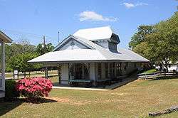 The former Mobile and Ohio Railroad Depot in the heart of the district | |
  | |
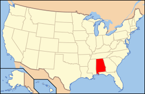
| Location | Roughly Centre and Main from Union to Faye, Citronelle, Alabama |
|---|---|
| Coordinates | 31°5′14″N 88°13′39″W / 31.08722°N 88.22750°WCoordinates: 31°5′14″N 88°13′39″W / 31.08722°N 88.22750°W |
| Area | 42.3 acres (17.1 ha) |
| Architectural style | Late Victorian |
| NRHP reference # | 89002421[1] |
| Added to NRHP | January 25, 1990 |
The Citronelle Railroad Historic District is a historic district in Citronelle, Alabama, United States. It is roughly bounded by Centre and Main streets from Union to Faye streets. The district covers 42.3 acres (0.171 km2) and contains 28 contributing properties.[2] It was placed on the National Register of Historic Places on January 25, 1990.[1]
References
| Wikimedia Commons has media related to Citronelle Railroad Historic District. |
- 1 2 National Park Service (2009-03-13). "National Register Information System". National Register of Historic Places. National Park Service.
- ↑ Bemis, Devereaux; Steven M. Kay (May 23, 1989). "Citronelle Railroad Historic District". National Register of Historic Places Registration Form. National Park Service. Archived (PDF) from the original on March 16, 2014. Retrieved March 16, 2014. See also: "Accompanying photos". Archived (PDF) from the original on March 16, 2014. Retrieved March 16, 2014.

This article is issued from
Wikipedia.
The text is licensed under Creative Commons - Attribution - Sharealike.
Additional terms may apply for the media files.