| [3] |
Name on the Register |
Image |
Date listed[4] |
Location |
City or town |
Description |
|---|
| 1 |
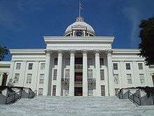
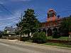
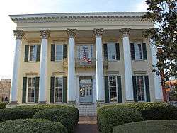
Alabama State Capitol |
|
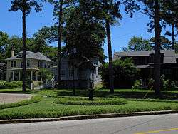
October 15, 1966
(#66000152) |
Goat Hill, eastern end of Dexter Ave.
32°22′40″N 86°18′02″W / 32.37775°N 86.30049°W / 32.37775; -86.30049 (Alabama State Capitol) |
Montgomery |
|
| 2 |
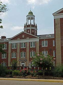
Alabama State University Historic District |
|
October 8, 1998
(#98001228) |
915 S. Jackson St.
32°21′51″N 86°17′51″W / 32.364167°N 86.2975°W / 32.364167; -86.2975 (Alabama State University Historic District) |
Montgomery |
|
| 3 |
Bell Building |
|
December 15, 1981
(#81000132) |
207 Montgomery St.
32°22′36″N 86°18′38″W / 32.37657°N 86.31066°W / 32.37657; -86.31066 (Bell Building) |
Montgomery |
|
| 4 |
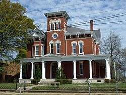
Brame House |
|
September 17, 1980
(#80000728) |
402-404 S. Hull St.
32°22′24″N 86°18′14″W / 32.37344°N 86.30387°W / 32.37344; -86.30387 (Brame House) |
Montgomery |
Building no longer at this location |
| 5 |
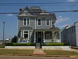
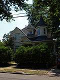
Patrick Henry Brittan House |
|
December 13, 1979
(#79000393) |
507 Columbus St.
32°22′57″N 86°18′08″W / 32.38241°N 86.30227°W / 32.38241; -86.30227 (Patrick Henry Brittan House) |
Montgomery |
|
| 6 |
Building 800-Austin Hall |
|
March 2, 1988
(#87002178) |
2nd St. at Maxwell Air Force Base
32°22′42″N 86°21′03″W / 32.37828°N 86.35083°W / 32.37828; -86.35083 (Building 800-Austin Hall) |
Montgomery |
|
| 7 |
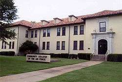
Building 836-Community College of the Air Force Building |
|
March 2, 1988
(#87002182) |
Maxwell Boulevard at Maxwell Air Force Base
32°22′49″N 86°21′07″W / 32.3804°N 86.35189°W / 32.3804; -86.35189 (Building 836-Community College of the Air Force Building) |
Montgomery |
|
| 8 |
Cassimus House |
|
August 13, 1976
(#76000349) |
110 N. Jackson St.
32°22′43″N 86°17′47″W / 32.37863°N 86.29636°W / 32.37863; -86.29636 (Cassimus House) |
Montgomery |
|
| 9 |
City of St. Jude Historic District |
|
June 18, 1990
(#90000916) |
2048 W. Fairview Ave.
32°21′10″N 86°19′37″W / 32.352778°N 86.326944°W / 32.352778; -86.326944 (City of St. Jude Historic District) |
Montgomery |
|
| 10 |
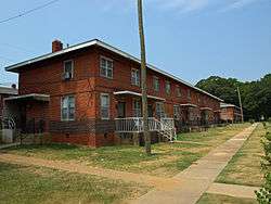
Cleveland Court Apartments 620–638 |
|
October 29, 2001
(#01001167) |
620-638 Cleveland Ct.
32°21′48″N 86°19′04″W / 32.36347°N 86.31783°W / 32.36347; -86.31783 (Cleveland Court Apartments 620–638) |
Montgomery |
|
| 11 |
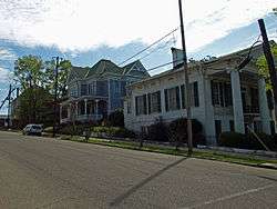
Cloverdale Historic District |
|
September 12, 1985
(#85002161) |
Roughly bounded by Norman Bridge and Cloverdale Rd., Fairview and Felder Aves. and Boultier St.
32°21′18″N 86°17′42″W / 32.355°N 86.295°W / 32.355; -86.295 (Cloverdale Historic District) |
Montgomery |
|
| 12 |
Cottage Hill Historic District |
|
November 7, 1976
(#76000350) |
Roughly bounded by Goldthwaite, Bell, Holt, and Clayton Sts.
32°22′29″N 86°19′05″W / 32.374722°N 86.318056°W / 32.374722; -86.318056 (Cottage Hill Historic District) |
Montgomery |
|
| 13 |
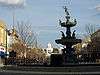
Court Square Historic District |
|
March 1, 1982
(#82002062) |
21-35 Court St., 1-2 Dexter Ave., 18-24 N. Court St., and Court Sq.; also roughly Dexter Ave. and Perry, Court, and Monroe Sts.
32°22′38″N 86°18′32″W / 32.377222°N 86.308889°W / 32.377222; -86.308889 (Court Square Historic District) |
Montgomery |
Second set of boundaries represents a boundary increase, the Court Square-Dexter Avenue Historic District Boundary Increase, listed on August 30, 1984 |
| 14 |
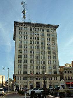
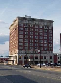
Jefferson Davis Hotel |
|
March 13, 1979
(#75000324) |
Catoma and Montgomery Sts.
32°22′33″N 86°18′45″W / 32.375833°N 86.3125°W / 32.375833; -86.3125 (Jefferson Davis Hotel) |
Montgomery |
|
| 15 |
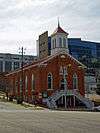
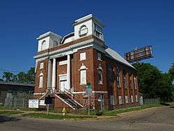
Dexter Avenue Baptist Church |
|
July 1, 1974
(#74000431) |
454 Dexter Ave.
32°22′38″N 86°18′10″W / 32.37732°N 86.30271°W / 32.37732; -86.30271 (Dexter Avenue Baptist Church) |
Montgomery |
|
| 16 |
Dowe Historic District |
|
December 29, 1988
(#88003076) |
320 and 334 Washington Ave. and 114-116 S. Hull St.
32°22′34″N 86°18′14″W / 32.376111°N 86.303889°W / 32.376111; -86.303889 (Dowe Historic District) |
Montgomery |
|
| 17 |
Edgewood |
|
April 24, 1973
(#73000367) |
3175 Thomas Ave.
32°20′49″N 86°17′12″W / 32.34683°N 86.28661°W / 32.34683; -86.28661 (Edgewood) |
Montgomery |
|
| 18 |
First White House of the Confederacy |
|
June 25, 1974
(#74000432) |
644 Washington Ave.
32°22′34″N 86°18′00″W / 32.37618°N 86.29995°W / 32.37618; -86.29995 (First White House of the Confederacy) |
Montgomery |
|
| 19 |
Garden District |
|
September 13, 1984
(#84000698) |
Roughly bounded by Norman Bridge Rd., Court St., and Jeff Davis and Fairview Aves.
32°21′29″N 86°18′19″W / 32.358056°N 86.305278°W / 32.358056; -86.305278 (Garden District) |
Montgomery |
|
| 20 |
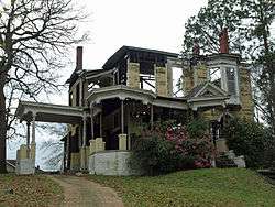
Gay House |
|
March 15, 1975
(#75000325) |
230 Noble Ave.
32°21′46″N 86°18′17″W / 32.36288°N 86.30479°W / 32.36288; -86.30479 (Gay House) |
Montgomery |
Destroyed by fire in 2007. |
| 21 |
Gerald-Dowdell House |
|
April 28, 1980
(#80000729) |
405 S. Hull St.
32°22′25″N 86°18′12″W / 32.37349°N 86.3033°W / 32.37349; -86.3033 (Gerald-Dowdell House) |
Montgomery |
|
| 22 |
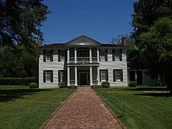
Governor's Mansion |
|
July 3, 1972
(#72000172) |
1142 S. Perry St.
32°21′43″N 86°18′27″W / 32.36192°N 86.30739°W / 32.36192; -86.30739 (Governor's Mansion) |
Montgomery |
|
| 23 |
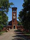
Grace Episcopal Church |
|
February 19, 1982
(#82002067) |
906 Pike Rd.
32°21′18″N 86°05′51″W / 32.3551°N 86.09737°W / 32.3551; -86.09737 (Grace Episcopal Church) |
Mount Meigs |
|
| 24 |
Grove Court Apartments |
|
December 11, 2013
(#13000894) |
559 S. Court St.
32°22′14″N 86°18′30″W / 32.370474°N 86.308327°W / 32.370474; -86.308327 (Grove Court Apartments) |
Montgomery |
|
| 25 |
Harrington Archaeological Site |
|
January 25, 1979
(#79000394) |
Address Restricted
|
Montgomery |
|
| 26 |
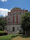
Huntingdon College Campus Historic District |
|
February 24, 2000
(#00000138) |
1500 E. Fairview Ave.
32°20′59″N 86°17′06″W / 32.349722°N 86.285°W / 32.349722; -86.285 (Huntingdon College Campus Historic District) |
Montgomery |
|
| 27 |
Jefferson Franklin Jackson House |
|
May 17, 1984
(#84000711) |
409 S. Union St.
32°22′25″N 86°17′56″W / 32.37348°N 86.29894°W / 32.37348; -86.29894 (Jefferson Franklin Jackson House) |
Montgomery |
|
| 28 |
Gov. Thomas G. Jones House |
|
December 8, 1978
(#78000506) |
323 Adams Ave.
32°22′32″N 86°18′14″W / 32.37545°N 86.30384°W / 32.37545; -86.30384 (Gov. Thomas G. Jones House) |
Montgomery |
|
| 29 |
Lower Commerce Street Historic District |
|
March 29, 1979
(#79000395) |
Roughly bounded by railroad tracks, Commerce, N. Court, and Bibb Sts.; also roughly bounded by railroad tracks, N. Court, Commerce, Coosa, and Tallapoosa Sts; also roughly bounded by the former Central of Georgia railroad tracks, N. Lawrence St., Madison Ave., and Commerce St.
32°22′49″N 86°18′38″W / 32.380278°N 86.310556°W / 32.380278; -86.310556 (Lower Commerce Street Historic District) |
Montgomery |
Second and third sets of boundaries represent boundary increases of February 25, 1982 and January 15, 1987 |
| 30 |
Maxwell Air Force Base Senior Officers' Quarters Historic District |
|
March 2, 1988
(#87002177) |
West Dr., N. Juniper and S. Juniper Sts., Inner Circle, Center Dr., Sequoia, and East Dr. at Maxwell Air Force Base
32°22′51″N 86°20′24″W / 32.380833°N 86.34°W / 32.380833; -86.34 (Maxwell Air Force Base Senior Officers' Quarters Historic District) |
Montgomery |
|
| 31 |
McBryde-Screws-Tyson House |
|
November 28, 1980
(#80000730) |
433 Mildred St.
32°22′14″N 86°18′54″W / 32.37052°N 86.3151°W / 32.37052; -86.3151 (McBryde-Screws-Tyson House) |
Montgomery |
|
| 32 |
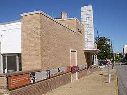
Montgomery Greyhound Bus Station |
|
May 16, 2011
(#11000298) |
210 S. Court St.
32°22′29″N 86°18′33″W / 32.37464°N 86.30912°W / 32.37464; -86.30912 (Montgomery Greyhound Bus Station) |
Montgomery |
Site of a clash between Freedom riders and protesters in 1961. Today serves as a museum for the Civil Rights Movement. |
| 33 |
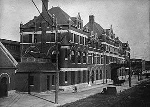
Montgomery Union Station and Trainshed |
|
July 24, 1973
(#73000368) |
Water St.
32°22′50″N 86°18′51″W / 32.38053°N 86.31406°W / 32.38053; -86.31406 (Montgomery Union Station and Trainshed) |
Montgomery |
|
| 34 |
Montgomery Veterans Administration Hospital Historic District |
|
March 19, 2012
(#12000141) |
215 Perry Hill Rd.
32°22′39″N 86°14′46″W / 32.377406°N 86.24622°W / 32.377406; -86.24622 (Montgomery Veterans Administration Hospital Historic District) |
Montgomery |
part of the United States Second Generation Veterans Hospitals Multiple Property Submission |
| 35 |
Mt. Zion AME Zion Church |
|
October 4, 2002
(#02001066) |
467 Holt St.
32°22′06″N 86°19′14″W / 32.36839°N 86.32052°W / 32.36839; -86.32052 (Mt. Zion AME Zion Church) |
Montgomery |
|
| 36 |
Muklassa |
|
August 28, 1973
(#73000369) |
Address Restricted
|
Montgomery |
|
| 37 |
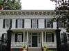
The Murphy House |
|
March 24, 1972
(#72000173) |
22 Bibb St.
32°22′48″N 86°18′35″W / 32.38006°N 86.30964°W / 32.38006; -86.30964 (The Murphy House) |
Montgomery |
|
| 38 |
Old Ship African Methodist Episcopal Zion Church |
|
January 24, 1991
(#90002177) |
483 Holcombe St.
32°22′17″N 86°18′42″W / 32.3714°N 86.31169°W / 32.3714; -86.31169 (Old Ship African Methodist Episcopal Zion Church) |
Montgomery |
|
| 39 |
Opp Cottage |
|
May 4, 1976
(#76000351) |
33 W. Jefferson Davis Ave.
32°21′58″N 86°18′36″W / 32.36603°N 86.30994°W / 32.36603; -86.30994 (Opp Cottage) |
Montgomery |
|
| 40 |
Ordeman-Shaw Historic District |
|
May 13, 1971
(#71000105) |
Bounded by McDonough, Decatur, Madison, and Randolph Sts.
32°22′54″N 86°18′14″W / 32.381667°N 86.303889°W / 32.381667; -86.303889 (Ordeman-Shaw Historic District) |
Montgomery |
|
| 41 |
Pastorium, Dexter Avenue Baptist Church |
|
March 10, 1982
(#82002064) |
309 S. Jackson St.
32°22′23″N 86°17′46″W / 32.37304°N 86.29605°W / 32.37304; -86.29605 (Pastorium, Dexter Avenue Baptist Church) |
Montgomery |
|
| 42 |
Pepperman House |
|
March 1, 1982
(#82002065) |
17 Mildred St.
32°22′15″N 86°18′35″W / 32.370833°N 86.309722°W / 32.370833; -86.309722 (Pepperman House) |
Montgomery |
|
| 43 |
Perry Street Historic District |
|
December 16, 1971
(#71000106) |
Roughly bounded by McDonough St. on the east, Sayre St. on the west, Washington St. on the north, and Donaldson St. on the south
32°22′26″N 86°18′27″W / 32.373889°N 86.3075°W / 32.373889; -86.3075 (Perry Street Historic District) |
Montgomery |
|
| 44 |
Powder Magazine |
|
April 13, 1973
(#73000370) |
End of Eugene St.
32°22′53″N 86°19′41″W / 32.381389°N 86.328056°W / 32.381389; -86.328056 (Powder Magazine) |
Montgomery |
American Civil War-era building for gunpowder storage. Located in Powder Magazine Park, the building is currently under restoration. |
| 45 |
St. John's Episcopal Church |
|
February 24, 1975
(#75000326) |
113 Madison Ave.
32°22′49″N 86°18′26″W / 32.38017°N 86.30735°W / 32.38017; -86.30735 (St. John's Episcopal Church) |
Montgomery |
|
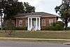
| 46 |
Sayre Street School |
|
February 19, 1982
(#82002066) |
506 Sayre St.
32°22′15″N 86°18′39″W / 32.37076°N 86.31079°W / 32.37076; -86.31079 (Sayre Street School) |
Montgomery |
|
| 47 |
Scott Street Firehouse |
|
February 12, 1981
(#81000133) |
418 Scott St.
32°22′25″N 86°18′11″W / 32.37349°N 86.30301°W / 32.37349; -86.30301 (Scott Street Firehouse) |
Montgomery |
|
| 48 |
Semple House |
|
September 27, 1972
(#72000174) |
S. Court & High Sts.
32°22′19″N 86°18′31″W / 32.37202°N 86.3086°W / 32.37202; -86.3086 (Semple House) |
Montgomery |
|
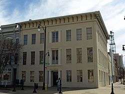
| 49 |
Shepherd Building |
|
May 22, 1986
(#86001106) |
312 Montgomery St.
32°22′34″N 86°18′43″W / 32.3762°N 86.31199°W / 32.3762; -86.31199 (Shepherd Building) |
Montgomery |
Demolished in 2010.[5] |
| 50 |
Jere Shine Site |
|
December 8, 1978
(#78000507) |
Address Restricted
|
Montgomery |
|
| 51 |
Smith-Joseph-Stratton House |
|
April 11, 1985
(#85000736) |
302 Alabama St.
32°22′26″N 86°18′17″W / 32.37392°N 86.30459°W / 32.37392; -86.30459 (Smith-Joseph-Stratton House) |
Montgomery |
|
| 52 |
South Perry Street Historic District |
|
August 30, 1984
(#84000713) |
Roughly Perry St. between Washington St. and Dexter Ave.
32°22′36″N 86°18′27″W / 32.376667°N 86.3075°W / 32.376667; -86.3075 (South Perry Street Historic District) |
Montgomery |
|
| 53 |
Stay House |
|
September 10, 1979
(#79000396) |
631 S. Hull St
32°22′10″N 86°18′11″W / 32.36943°N 86.30318°W / 32.36943; -86.30318 (Stay House) |
Montgomery |
|
| 54 |
Steiner-Lobman and Teague Hardware Buildings |
|
January 31, 1979
(#79000397) |
184 and 172 Commerce St.
32°22′49″N 86°18′41″W / 32.38024°N 86.31144°W / 32.38024; -86.31144 (Steiner-Lobman and Teague Hardware Buildings) |
Montgomery |
|
| 55 |
Stone Plantation |
|
December 31, 2001
(#01001411) |
5001 Old Selma Rd.
32°21′02″N 86°25′31″W / 32.35067°N 86.4254°W / 32.35067; -86.4254 (Stone Plantation) |
Montgomery |
|
| 56 |
Tankersley Rosenwald School |
|
January 22, 2009
(#08001332) |
10 miles (16 km) south of Montgomery on U.S. Route 31 to Pettus Rd. to School Spur on the western side
32°08′32″N 86°21′25″W / 32.14231°N 86.35685°W / 32.14231; -86.35685 (Tankersley Rosenwald School) |
Hope Hull |
|
| 57 |
Dr. C.A. Thigpen House |
|
December 13, 1977
(#77000215) |
1412 S. Perry St.
32°21′33″N 86°18′26″W / 32.35924°N 86.30729°W / 32.35924; -86.30729 (Dr. C.A. Thigpen House) |
Montgomery |
|
| 58 |
Tulane Building |
|
March 21, 1979
(#79000398) |
800 High St.
32°22′19″N 86°17′52″W / 32.37191°N 86.29767°W / 32.37191; -86.29767 (Tulane Building) |
Montgomery |
|
| 59 |
Tyson-Maner House |
|
May 10, 1979
(#79000399) |
469 S. McDonough St.
32°22′20″N 86°18′16″W / 32.37213°N 86.30441°W / 32.37213; -86.30441 (Tyson-Maner House) |
Montgomery |
|
| 60 |
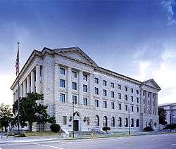
United States Post Office and Courthouse-Montgomery |
|
June 3, 1998
(#98000611) |
Church St. between Moulton and Lee Sts.
32°22′30″N 86°18′34″W / 32.37507°N 86.30958°W / 32.37507; -86.30958 (United States Post Office and Courthouse-Montgomery) |
Montgomery |
Many important civil rights cases heard and decided in this 1933 building |
| 61 |
Wharton-Chappell House |
|
July 19, 2016
(#16000445) |
1020 Maxwell Blvd.
32°22′40″N 86°19′43″W / 32.3778°N 86.32868°W / 32.3778; -86.32868 (Wharton-Chappell House) |
Montgomery |
|
| 62 |
Winter Building |
|
January 14, 1972
(#72000175) |
2 Dexter Ave.
32°22′38″N 86°18′32″W / 32.3771°N 86.30881°W / 32.3771; -86.30881 (Winter Building) |
Montgomery |
|
| 63 |
Winter Place |
|
May 31, 2006
(#06000439) |
454 S. Goldthwaite St.
32°22′17″N 86°18′57″W / 32.37136°N 86.31584°W / 32.37136; -86.31584 (Winter Place) |
Montgomery |
|
| 64 |
William Lowndes Yancey Law Office |
|
November 7, 1973
(#73000371) |
Washington and Perry Sts.
32°22′35″N 86°18′26″W / 32.37644°N 86.30712°W / 32.37644; -86.30712 (William Lowndes Yancey Law Office) |
Montgomery |
|