Ciomadul
| Ciomadul | |
|---|---|
| Csomád (hu) | |
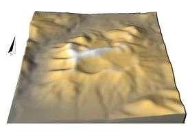 3D model of Ciomadul's central sector seen from the south | |
| Highest point | |
| Elevation | 1,289 m (4,229 ft) [1] |
| Coordinates | 46°08′N 25°53′E / 46.13°N 25.88°ECoordinates: 46°08′N 25°53′E / 46.13°N 25.88°E [1] |
| Geography | |
 Ciomadul | |
| Parent range | Carpathian Mountains |
| Geology | |
| Age of rock | Pleistocene |
| Mountain type | Dacitic volcano |
| Volcanic belt |
Călimani–Gurghiu–Harghita volcanic chain |
Ciomadul is a volcano in Romania, and is known as Csomád in Hungarian.[2] It is in the Carpathians, close to the towns of Băile Tușnad and Bixad. It is part of a volcanic chain known as the Călimani (Kelemen) – Gurghiu (Görgényi) – Harghita (Hargita) chain and lies at its southeastern end. Ciomadul consists of several lava domes with two embedded explosion craters known as Mohos and St. Ana, the latter of which contains a crater lake, Lake Sfânta Ana. The dominant volcanic rock at Ciomadul is potassium-rich dacite.
Volcanic activity at Ciomadul commenced with effusive activity about one million years ago. Most of the volcano was constructed between 650,000 – 500,000 years ago.
Between 56,000 and 32,000 years ago explosive volcanic activity occurred at Ciomadul. Both the exact dates of the various eruptions and of the formation of the St. Ana and Mohos craters are unclear, partly because dates obtained by potassium-argon dating and other dating techniques deviate from each other. Some eruptions may have reached sub-Plinian strength, ejecting volcanic ash as far as the Black Sea.
The last eruption took place between 32,600 and 27,500 years ago. Its date is likewise unclear. Ongoing seismic and geothermal activity, and exhalations of volcanic gas and evidence of a still existing magma chamber indicate that Ciomadul is a potentially active volcano.
Geography and geology
Regional setting
With the exception of Greece and Italy, historical volcanism has not taken place in Continental Europe. The most recent volcanic activity occurred between 40,000 and 6,500 years ago in Garrotxa, the Massif Central and the Vulkaneifel.[3]
Volcanism in the region of Carpathia and Pannonia has been ongoing since 20 million years ago but has decreased during the Quaternary. No eruptions have occurred in the Holocene.[4] The last volcanism occurred at Ciomadul in the last glacial age.[2] Sparse basaltic volcanism has also occurred in the area, forming monogenetic volcanic fields.[5]
A 700 kilometres (430 mi) volcanic arc lies in the Carpathians. In its southern segment, also known as the Călimani (Kelemen) – Gurghiu (Görgényi) – Harghita (Hargita) chain,[6][7][8] volcanism has migrated between 9 and 0.22 million years ago southward, forming a c. 100 kilometres (62 mi) long volcanic chain.[9] Magma output progressively decreased during time, with early volcanoes being large stratovolcanoes sometimes featuring caldera-forming eruptions, while more recent activity includes monogenetic volcanoes.[10][11]
This volcanism occurs in a setting where the collision between the Eurasian Plate and the Tisza-Dacia microplate took place.[12][13] This is part of the collision between the African Plate and the Eurasian Plate; subduction may still be underway in the area of the Carpathians.[14] The Vrancea zone, which is 50 kilometres (31 mi) away from Ciomadul, features ongoing earthquake activity; deep earthquakes suggest that a remnant of a slab exists beneath the Vrancea zone.[15] This tectonic setting may also be responsible for volcanism at Ciomadul and the Persani volcanic field,[16] 40 kilometres (25 mi) south of Ciomadul.[17] Other theories on Ciomadul's volcanic activity imply delamination of the lithosphere or roll-back of the subduction zone.[18]
Volcanism in this chain is calc-alkaline, yielding both andesite, dacite,[9] and rhyolite.[7] Three million years ago, a change in the chemistry of volcanism occurred, with an increased content of potassium in the rocks. This change in composition geographically coincided with the volcanic activity crossing a lineament known as the Trotus line.[9][18][8]
Volcano
Ciomadul is located in the southeastern Carpathians,[4] at the end of the Călimani (Kelemen) – Gurghiu (Görgényi) – Harghita (Hargita) volcanic chain.[9] The gorge of the Olt River separates Ciomadul from the Harghita Mountains.[19] The towns of Băile Tușnad and Bixad are close to the volcano,[20] and a road leads up the volcano from the southeast and goes past the Mohos swamp to the St. Ana lake.[21] The basement of the volcano is formed by flysch of Cretaceous age.[12][13]
The idea that Ciomadul could be a still active volcano was first proposed in 1780 on the basis of its young appearance and the release of gas. While a publication in 1964 postulated that the tuffs of Ciomadul were reworked Pliocene volcanites, the late Pleistocene age was established soon afterwards.[22]
Ciomadul is formed by a complex of lava domes and other volcanic material that form a south-tilting ridge that rises above the 700 metres (2,300 ft) high surrounding Lower Ciuk Basin. Individual lava domes form cone-shaped hills,[19] which reach heights of 300–400 metres (980–1,310 ft) and widths of 1–2 kilometres (0.62–1.24 mi). Individual domes include Haramul Ierbos (Fű-Haram in Hungarian), Haramul Mare (Nagy-Haram), Haramul Mic (Kis-Haram), Vf. Cetăţii (Vár-tető), Vf. Comloş (Komlós-tető) and Vf. Surduc (Szurdok-tető).[23] The central cluster of domes is elliptical.[12] The highest point of the complex is Ciomadul Mare (Nagy-Csomád) with an altitude of 1,301 metres (4,268 ft).[19] Some domes were later affected by erosion, explosive activity[24] or fumarolic alteration.[13] The whole volcanic complex covers a surface area of 80 square kilometres (31 sq mi),[12] and is surrounded by a circular/semicircular plain made of volcanic debris.[25]
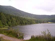
The lava dome complex contains two craters, named Mohos and St. Ana. They were formed in the previously existing lava domes.[9][26] The St. Ana crater is c. 1,600 metres (5,200 ft) wide and c. 200 metres (660 ft) deep beneath the rim, comparable with the crater of El Chichón volcano in Mexico.[23] This crater lacks a breach and is relatively unaffected by erosion.[27] It contains a 6 metres (20 ft) deep crater lake,[9] which once may have been over 12 metres (39 ft) deep. This c. 189.9 square kilometres (73.3 sq mi) large lake is known as Lake Sfânta Ana (46°07′35″N 25°53′17″E / 46.12639°N 25.88806°E) and lies at an altitude of 946 metres (3,104 ft).[25][28]
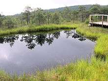
The Mohos crater lies at an altitude of 1,050 metres (3,440 ft).[29] It is larger than St. Ana with a diameter of 1.9 kilometres (1.2 mi) and not as deep.[30] with its bottom lying above sea level. It is filled with a 800,000 square metres (80 ha) large and 10 metres (33 ft) thick Sphagnum peat bog and its rim is cut by the St. Ana crater.[23][31]
Unlike St. Ana, the Mohos crater has been breached by erosion, causing the formation of an outlet valley.[32] Both craters were formed by explosive eruptions and distinguishing between the deposits of both is difficult.[9] The existence of an even larger crater with a diameter 2–2.5 kilometres (1.2–1.6 mi) has been suggested,[33] encompassing both St. Ana and Mohos.[34]
Pyroclastic flow deposits generated by Ciomadul have been found on its northeastern, southern and western slopes.[23] They reach a distance of as much as 25 kilometres (16 mi) from the volcano.[9] At Tusnad road, one of the flows has a thickness of c. 10 metres (33 ft).[35] Tephra fall bed,[9] lapilli,[35] and surge deposits are also found, and the flow deposits contain pumice blocks.[9] One lapilli layer, 20–23 centimetres (7.9–9.1 in) thick, from Ciomadul has been identified 40 kilometres (25 mi) east of the volcano.[36] The whole pyroclastic formation has been subdivided into three classes known as "Early Phreatomagmatic + Plinian Activity", "Middle Plinian Activity" and "Latest St. Ana Phreatomagmatic Activity". Each comprise a number of individual tephra layers.[37]
Other landforms at Ciomadul include coulees and lava flows.[12] The total volume of the complex is about 8–15 cubic kilometres (1.9–3.6 cu mi) dense rock equivalent.[15] Drilling has identified the existence of an intrusion at a depth of 575 metres (1,886 ft).[12]
Older volcanic centres extend northwest of Ciomadul. With increasing distance they are 2.5–1.5 million years old Pilisca centre, the 2.8–2.2 million years old Cucu centre and the 4.3–3.6 million years old Luci-Lazu and Sumuleu-Ciuc volcanic centres. South of Ciomadul the Murgul shoshonites were erupted 2.3–1.5 million years ago;[38][39] they represent cryptodomes.[15] Andesite lava flows from Pilisca underlie the Ciomadul deposits in some places.[40]
Composition
The principal rock is dacite, rich in potassium.[6] The rocks have a porphyric appearance and contain few vesicles. They are also very rich in crystals,[41][11][42] with the dominant phenocryst-forming minerals being biotite, hornblende and plagioclase. Less important are allanite, apatite, clinopyroxene, olivine, orthopyroxene, quartz, sphene and zircon.[11][19] The groundmass contains plagioclase, pyroxene, silicon dioxide and oxides of iron and titanium.[42] The composition of Ciomadul's rocks has been fairly constant throughout its evolution[26] albeit with two shifts 1 million and 650,000 years before present,[43] and this diversity of its components indicate that the genesis of Ciomadul magmas involved mixing between felsic and mafic magma.[20]
A large proportion of crystals in the rocks consists of antecrysts and xenocrysts, making radiometric dating of the rocks difficult. These include the amphibole, biotite, feldspar and zircon.[9]
The temperature of the magma chamber has been estimated to be about 700–750 metres (2,300–2,460 ft), with heating of over 200 °C (360 °F) occurring before some eruptions according to thermometry calculation. Volcanic activity was most likely triggered by the injection of basaltic magma into the felsic magma chamber before the actual eruption.[44][45] The amphiboles in the rocks formed at depths of 7–14 kilometres (4.3–8.7 mi).[46] The magma output of Ciomadul is about 0.009 cubic kilometres per millennium (0.0022 cu mi/ka).[47]
Climate and vegetation
Ciomadul is located in a temperate climate zone. Rainfall reaches 800–1,000 millimetres (31–39 in), resulting in strong erosion.[23] The annual mean temperature is 7.6 °C (45.7 °F) at Sfintu Gheorghe, the nearest meteorological station.[48] Around St. Ana, July mean temperatures are 15 °C (59 °F) and January temperatures −5 to −6 °C (23 to 21 °F).[25]
While some glaciation occurred in the Carpathians during the ice ages, no glacial activity is recorded at Ciomadul. The volcano was unforested at that time,[25] with steppe and tundra vegetation comprising most of the reported flora.[49]
Ciomadul is covered by beech and spruce forests.[50] Around St. Ana lake, the vegetation is mostly formed by Fagus sylvatica (common beech) and Picea abies (Norway spruce) woods. Other trees include Acer platanoides (Norway maple), Betula pendula (silver birch), Carpinus betulus (common hornbeam), Pinus sylvestris (Scots pine), Salix caprea (goat willow) and Salix cinerea (grey willow). A fen contains Carex lasiocarpa (slender sedge), Carex rostrata (bottle sedge), Lysimachia thyrsiflora (tufted loosestrife) and Sphagnum angustifolium (fine bogmoss).[25] At Mohos, vegetation consists of Alnus glutinosa (common alder), Betula pendula and Salix. The peat bog contains trees (Pinus sylvestris and Betula pubescens (downy birch)) and Ericaceae.[50]
Eruptive history
Ciomadul has been active for over half a million years,[4] with the oldest activity between 1,000,000 and 750,000 years ago forming lava domes.[9][43] Older estimates indicate that activity did not start before 250,000 years ago, while more recent research indicated a start of volcanism over 600,000 years ago.[16][26] Volcanism at Ciomadul consisted mostly of the extrusion of lava domes, their collapse forming block-and-ash flows and subplinian and Vulcanian eruptions.[16]
A gap of about 500,000 years separates Ciomadul from the activity of other volcanoes in the area.[51] The two oldest dates of 1,020,000 and 850,000 years ago were obtained on peripheral lava domes.[52] Activity reached a peak between c. 650,000 – 500,000 years ago, when the principal lava domes were formed.[9] This effusive phase is also known as "old Ciomadul",[18] and eruptions were separated by long pauses without volcanic activity from each other.[53] The youngest lava dome was dated at 42,900 ± 1,500 years ago by uranium-thorium dating. The dates obtained by potassium-argon dating are much older;[54] there is substantial disagreement between dates obtained by potassium-argon dating or argon-argon dating on the one hand and uranium-thorium dating on the other hand at Ciomadul.[55][53] These dates indicate that the formation of the central lava domes took place between 590,000 and 140,000 years ago.[56]
Between 56,000 and 32,000 years ago, explosive activity occurred at Ciomadul. That timespan coincides with the deposition of tephra from volcanoes in Italy in Europe; it is possible that tephra also came from Ciomadul.[15] Indeed, the age of Ciomadul's last eruption overlaps with the age of the Campanian Ignimbrite.[44] Tephra from eruptions of Ciomadul has also bee found in the Ursului Cave of the Perșani Mountains.[57] Some tephra layers found in two drilling cores of the Black Sea may have originated at Ciomadul.[58]
An earlier explosive eruption about 55,900 ± 2,300 years ago may be the origin of the Mohos crater,[55] with another proposed potassium-argon date being c. 220,000 years ago. Mohos crater is probably older than the St. Ana crater.[59] A phreatomagmatic deposit northeast of Mohos was formed by an eruption of the Mohos crater;[36] this eruption may be the source of the "Turia type" phreatomagmatic deposits,[60] which is dated to have occurred about 51,000 ± 4,800 years ago.[61] In one view, a volcanically quied period followed an effusive eruption 42,900 years ago named "Piscul Pietros" and lasted until 31,510 years ago,[62] when a Plinian eruption occurred. This latter eruption deposited 0.6 metres (2 ft 0 in) thick ash as far as 21 kilometres (13 mi) from the vent at one site.[63] Alternatively, 38,900 ± 1,700 years ago a subplinian eruption occurred at Ciomadul; it may have formed the St. Ana crater.[54] This date would correspond to that of the so-called "MK-202" tephra.[64]
The age of the last eruption is controversial.[4] In 1994, radiocarbon dating yielded an age of 10,700 ± 800 years Before Present from a pyroclastic flow. Later, paleosoils and other samples from the same flow were used to deduce similar ages of over 36,770, 42,650, over 35,670 and over 35,520 years before present, respectively.[21] Thus this youngest age estimate was discarded.[65] In 2010, further research identified two younger eruptions, one occurring 39,000 years Before Present and the other 27,500 years Before Present.[9] Other data obtained by uranium-thorium dating indicate an age of 32,600 ± 1,000 years ago for the youngest eruption.[54] Both of these eruptions took place at St. Ana and imply a repose period between eruptions of over 10,000 years.[59] Much older dates obtained by potassium-argon dating are not considered reliable.[52] Alternatively, the latest eruption may have occurred at a satellite vent seeing as sedimentation of the St. Ana lake has been ongoing since 26,000 years ago.[33] These two recent eruptions were fed by different magmas, with the younger eruption coming from deeper magma chambers (5–12 kilometres (3.1–7.5 mi) versus 4 kilometres (2.5 mi)) and involving more primitive magma.[66] The youngest eruption was probably very violent; the Roxolany Tephra which may be associated with it has been found as far as Odessa, Ukraine, 350 kilometres (220 mi) away from Ciomadul.[60] If the Roxolany Tephra was formed by the youngest eruption of Ciomadul, the youngest eruption would have occurred 29,600 calibrated radiocarbon years ago based on independent dates of the tephra.[58]
Current status
Presently, Ciomadul displays seismic activity, release of carbon dioxide from mofettas and anomalous heat flow,[19] reaching 85–120 watts per square metre (0.0106–0.0150 hp/sq ft).[26] Outgassing of carbon dioxide, hydrogen sulfide and mostly abiotic methane have been found at Ciomadul.[67] The total output of carbon dioxide exceeds about 8,700 tonnes (8,600 long tons; 9,600 short tons)[68] per year, while the output of methane amounts to methane 1.3 tonnes (1.3 long tons; 1.4 short tons) per year.[67] Carbon dioxide concentrations in some places such as caverns can be high enough to become dangerous to people and animals, and is reflected in place names such as Peștera Ucigașă (Gyilkos-barlang) which mean "killer cave".[13]
At depths of 8 to 20 kilometres (5.0 to 12.4 mi), a magma chamber has been identified beneath Ciomadul,[26][23] based on magnetotelluric data.[69] A deeper basaltic melt zone may also exist.[70] Further, a zone of low seismic velocity has been identified with geophysical and seismic modelling in the lower crust and upper mantle beneath Ciomadul, down to depths of 110 kilometres (68 mi) or 400 kilometres (250 mi).[17]
Hydrothermal activity has been noted at Ciomadul and Tusnand-Bai, including a high temperature system at depth with temperatures exceeding 225 °C (437 °F).[14] The Tusnand-Bai springs have temperatures of 15–23 °C (59–73 °F) and discharge salty, carbon dioxide-rich water which emerges from pyroclastic deposits.[71]
Future activity
Volcanoes are usually considered to be active if they have had eruptions during the Holocene. However, as demonstrated by the unexpected eruption of Chaiten volcano in Chile in May 2008, even long-inactive volcanoes can become active again. Such volcanoes can constitute a threat to regions with seemingly quiet volcanism.[4] Ciomadul has had repose periods of over 10,000 years and possibly even longer.[59] Zircon crystallization data imply that the magma chambers of Ciomadul were active over time spans of over 300,000 years.[44]
Uniquely, Ciomadul is a still alive volcano in Eastern Europe and its craters have a youthful appearance.[23] There is always the possibility of renewed volcanic activity if the magma chamber has not solidified.[72] Deep earthquake activity at Ciomadul occurs down to a depth of 70 kilometres (43 mi), indicating that the volcanic system between the magma chamber and lithospheric melts is still active.[73] It is considered to be a potentially active volcano.[18]
References
- 1 2 "South Harghita Mountains". Global Volcanism Program. Smithsonian Institution.
- 1 2 Karátson et al. 2013, p. 43.
- ↑ Harangi et al. 2015, pp. 66–67.
- 1 2 3 4 5 Harangi et al. 2010, p. 1498.
- ↑ Harangi et al. 2013, p. 44.
- 1 2 Kis et al. 2017, p. 120.
- 1 2 Karátson et al. 2013, p. 44.
- 1 2 Molnár et al. 2018, p. 3.
- 1 2 3 4 5 6 7 8 9 10 11 12 13 14 Harangi et al. 2010, p. 1500.
- ↑ Szakács et al. 2015, p. 2.
- 1 2 3 Karátson et al. 2016, p. 30.
- 1 2 3 4 5 6 Szakács et al. 2015, p. 3.
- 1 2 3 4 Kis et al. 2017, p. 121.
- 1 2 Mitrofan 2000, p. 1447.
- 1 2 3 4 Harangi et al. 2015, p. 67.
- 1 2 3 Harangi et al. 2015, p. 69.
- 1 2 Harangi et al. 2013, p. 48.
- 1 2 3 4 Kiss et al. 2014, p. 2.
- 1 2 3 4 5 Karátson et al. 2013, p. 45.
- 1 2 Harangi et al. 2015, p. 85.
- 1 2 Harangi et al. 2010, p. 1499.
- ↑ Karátson et al. 2016, p. 32.
- 1 2 3 4 5 6 7 Karátson et al. 2013, p. 46.
- ↑ Szakács et al. 2015, p. 5.
- 1 2 3 4 5 Magyari et al. 2014, p. 281.
- 1 2 3 4 5 Harangi et al. 2015, p. 83.
- ↑ Karátson et al. 1999, p. 178.
- ↑ Karátson et al. 2013, p. 50.
- ↑ Tantau et al. 2003, p. 113.
- ↑ Szakács et al. 2015, p. 6.
- ↑ Tantau et al. 2003, pp. 113–114.
- ↑ Karátson et al. 1999, p. 181.
- 1 2 Karátson et al. 2013, p. 53.
- ↑ Karátson et al. 2013, p. 54.
- 1 2 Harangi et al. 2010, p. 1501.
- 1 2 Szakács et al. 2015, p. 8.
- ↑ Karátson et al. 2016, p. 44.
- ↑ Harangi et al. 2015, p. 84.
- ↑ Harangi et al. 2015, p. 68.
- ↑ Szakács et al. 2015, p. 7.
- ↑ Molnár et al. 2018, p. 4.
- 1 2 Kiss et al. 2014, p. 4.
- 1 2 Molnár et al. 2018, p. 14.
- 1 2 3 Harangi et al. 2015, p. 76.
- ↑ Kiss et al. 2014, p. 24.
- ↑ Harangi et al. 2015, p. 87.
- ↑ Szakács et al. 2015, p. 15.
- ↑ Karátson et al. 1999, p. 180.
- ↑ Magyari et al. 2014, p. 295.
- 1 2 Tantau et al. 2003, p. 114.
- ↑ Szakács et al. 2015, p. 14.
- 1 2 Karátson et al. 2013, p. 49.
- 1 2 Molnár et al. 2018, p. 12.
- 1 2 3 Harangi et al. 2015, p. 74.
- 1 2 Harangi et al. 2015, p. 75.
- ↑ Szakács et al. 2015, p. 12.
- ↑ Veres, Daniel; Cosac, Marian; Schmidt, Christoph; Murătoreanu, George; Hambach, Ulrich; Hubay, Katalin; Wulf, Sabine; Karátson, David (July 2017). "New chronological constraints for Middle Palaeolithic (MIS 6/5-3) cave sequences in Eastern Transylvania, Romania". Quaternary International: 9–10. doi:10.1016/j.quaint.2017.07.015. ISSN 1040-6182.
- 1 2 Wulf, Sabine; Fedorowicz, Stanisław; Veres, Daniel; Łanczont, Maria; Karátson, Dávid; Gertisser, Ralf; Bormann, Marc; Magyari, Enikö; Appelt, Oona (2016-08-01). "The 'Roxolany Tephra' (Ukraine) − new evidence for an origin from Ciomadul volcano, East Carpathians". Journal of Quaternary Science. 31 (6): 574. doi:10.1002/jqs.2879. ISSN 1099-1417.
- 1 2 3 Harangi et al. 2010, p. 1505.
- 1 2 Karátson, Dávid; Wulf, Sabine; Veres, Daniel; Gertisser, Ralf; Telbisz, Tamás; Magyari, Enikö (2016-04-01). "Paleo-geomorphic evolution of the Ciomadul volcano (East Carpathians, Romania) using integrated volcanological, stratigraphical and radiometric data". 18: 11738. Bibcode:2016EGUGA..1811738K.
- ↑ Karátson et al. 2016, p. 46.
- ↑ Karátson et al. 2016, p. 47.
- ↑ Karátson et al. 2016, p. 49.
- ↑ Danišík, Martin; Schmitt, Axel K.; Stockli, Daniel F.; Lovera, Oscar M.; Dunkl, István; Evans, Noreen J. "Application of combined U-Th-disequilibrium/U-Pb and (U-Th)/He zircon dating to tephrochronology". Quaternary Geochronology: 7. doi:10.1016/j.quageo.2016.07.005.
- ↑ Karátson et al. 2016, p. 33.
- ↑ Harangi et al. 2010, p. 1504.
- 1 2 Kis, Boglárka-Mercedesz; Ionescu, Artur; Harangi, Szabolcs; Palcsu, László; Etiope, Giuseppe; Baciu, Calin (2016-04-01). "Gas geochemical survey of long dormant Ciomadul volcano (South Harghita Mts., Romania): constraints on the flux and origin of fluids". 18: 9576. Bibcode:2016EGUGA..18.9576K.
- ↑ Kis et al. 2017, p. 125.
- ↑ Harangi et al. 2015, p. 93.
- ↑ Novák, A.; Harangi, Sz.; Kiss, B.; Szarka, L.; Molnár, Cs. (2012-04-01). "Combined magnetotelluric and petrologic constrains for the nature of the magma storage system beneath the Ciomadul volcano (SE Carpathians)". 14: 7637. Bibcode:2012EGUGA..14.7637N.
- ↑ Mitrofan 2000, p. 1448.
- ↑ Harangi et al. 2015, pp. 82–83.
- ↑ Szakács et al. 2015, p. 16.
Bibliography
- Harangi, Szabolcs; Lukács, R.; Schmitt, A. K.; Dunkl, I.; Molnár, K.; Kiss, B.; Seghedi, I.; Novothny, Á.; Molnár, M. (2015-08-15). "Constraints on the timing of Quaternary volcanism and duration of magma residence at Ciomadul volcano, east–central Europe, from combined U–Th/He and U–Th zircon geochronology". Journal of Volcanology and Geothermal Research. 301: 66–80. doi:10.1016/j.jvolgeores.2015.05.002.
- Harangi, Szabolcs; Molnár, M; Vinkler, A P; Kiss, B; Jull, A J T; Leonard, A G (2010-08-01). "Radiocarbon Dating of the Last Volcanic Eruptions of Ciomadul Volcano, Southeast Carpathians, Eastern-Central Europe". Radiocarbon. 52 (3). doi:10.2458/azu_js_rc.52.3648. ISSN 0033-8222.
- Harangi, Szabolcs; Novák, A.; Kiss, B.; Seghedi, I.; Lukács, R.; Szarka, L.; Wesztergom, V.; Metwaly, M.; Gribovszki, K. (2015-01-01). "Combined magnetotelluric and petrologic constrains for the nature of the magma storage system beneath the Late Pleistocene Ciomadul volcano (SE Carpathians)". Journal of Volcanology and Geothermal Research. 290: 82–96. doi:10.1016/j.jvolgeores.2014.12.006.
- Harangi, Szabolcs; Sági, Tamás; Seghedi, Ioan; Ntaflos, Theodoros (2013-11-01). "Origin of basaltic magmas of Perşani volcanic field, Romania: A combined whole rock and mineral scale investigation". Lithos. Magmatic response to the post-accretionary orogenesis within Alpine–Himalayan belt. 180–181: 43–57. doi:10.1016/j.lithos.2013.08.025.
- Karátson, Dávid; Telbisz, Tamás; Harangi, Szabolcs; Magyari, Enikő; Dunkl, István; Kiss, Balázs; Jánosi, Csaba; Veres, Daniel; Braun, Mihály (2013-04-01). "Morphometrical and geochronological constraints on the youngest eruptive activity in East-Central Europe at the Ciomadul (Csomád) lava dome complex, East Carpathians". Journal of Volcanology and Geothermal Research. 255: 43–56. doi:10.1016/j.jvolgeores.2013.01.013.
- Karátson, Dávid; Thouret, Jean-Claude; Moriya, Ichio; Lomoschitz, Alejandro (1999). "Erosion calderas: origins, processes, structural and climatic control". Bulletin of Volcanology. 61 (3): 174–193. doi:10.1007/s004450050270. ISSN 0258-8900.
- Karátson, D.; Wulf, S.; Veres, D.; Magyari, E. K.; Gertisser, R.; Timar-Gabor, A.; Novothny, Á.; Telbisz, T.; Szalai, Z. (2016-06-01). "The latest explosive eruptions of Ciomadul (Csomád) volcano, East Carpathians — A tephrostratigraphic approach for the 51–29 ka BP time interval". Journal of Volcanology and Geothermal Research. 319: 29–51. doi:10.1016/j.jvolgeores.2016.03.005.
- Kis, Boglárka-Mercédesz; Ionescu, Artur; Cardellini, Carlo; Harangi, Szabolcs; Baciu, Călin; Caracausi, Antonio; Viveiros, Fátima (15 July 2017). "Quantification of carbon dioxide emissions of Ciomadul, the youngest volcano of the Carpathian-Pannonian Region (Eastern-Central Europe, Romania)". Journal of Volcanology and Geothermal Research. 341: 119–130. doi:10.1016/j.jvolgeores.2017.05.025. ISSN 0377-0273.
- Kiss, Balázs; Harangi, Szabolcs; Ntaflos, Theodoros; Mason, Paul R. D.; Pál-Molnár, Elemér (2014-03-05). "Amphibole perspective to unravel pre-eruptive processes and conditions in volcanic plumbing systems beneath intermediate arc volcanoes: a case study from Ciomadul volcano (SE Carpathians)". Contributions to Mineralogy and Petrology. 167 (3): 986. doi:10.1007/s00410-014-0986-6. ISSN 0010-7999.
- Magyari, E. K.; Veres, D.; Wennrich, V.; Wagner, B.; Braun, M.; Jakab, G.; Karátson, D.; Pál, Z.; Ferenczy, Gy (2014-12-15). "Vegetation and environmental responses to climate forcing during the Last Glacial Maximum and deglaciation in the East Carpathians: attenuated response to maximum cooling and increased biomass burning". Quaternary Science Reviews. Dating, Synthesis, and Interpretation of Palaeoclimatic Records and Model-data Integration: Advances of the INTIMATE project(INTegration of Ice core, Marine and TErrestrial records, COST Action ES0907). 106: 278–298. doi:10.1016/j.quascirev.2014.09.015.
- Mitrofan, Horia (2000). "TUSNAD-BAI – A GEOTHERMAL SYSTEM ASSOCIATED WITH THE MOST RECENT VOLCANIC ERUPTION IN ROMANIA" (PDF). pangea.stanford.edu. IGA Geothermal Papers Online Database. Retrieved 2016-12-19.
- Molnár, Kata; Harangi, Szabolcs; Lukács, Réka; Dunkl, István; Schmitt, Axel K.; Kiss, Balázs; Garamhegyi, Tamás; Seghedi, Ioan (February 2018). "The onset of the volcanism in the Ciomadul Volcanic Dome Complex (Eastern Carpathians): Eruption chronology and magma type variation". Journal of Volcanology and Geothermal Research. doi:10.1016/j.jvolgeores.2018.01.025. ISSN 0377-0273.
- Szakács, Alexandru; Seghedi, Ioan; Pécskay, Zoltán; Mirea, Viorel (2015-01-30). "Eruptive history of a low-frequency and low-output rate Pleistocene volcano, Ciomadul, South Harghita Mts., Romania". Bulletin of Volcanology. 77 (2): 12. doi:10.1007/s00445-014-0894-7. ISSN 0258-8900.
- Tantau, Ioan; Reille, Maurice; Beaulieu, Jacques-Louis de; Farcas, Sorina; Goslar, Tomasz; Paterne, Martine (2003-08-05). "Vegetation history in the Eastern Romanian Carpathians: pollen analysis of two sequences from the Mohoş crater". Vegetation History and Archaeobotany. 12 (2): 113–125. doi:10.1007/s00334-003-0015-6. ISSN 0939-6314.
External links
| Wikimedia Commons has media related to St. Ana. |
| Wikimedia Commons has media related to Mohos Peat Bog. |