Christmas, Mississippi
| Christmas, Mississippi | |
|---|---|
| Unincorporated community | |
 Christmas, Mississippi  Christmas, Mississippi | |
| Coordinates: 33°46′35″N 90°58′42″W / 33.77639°N 90.97833°WCoordinates: 33°46′35″N 90°58′42″W / 33.77639°N 90.97833°W | |
| Country | United States |
| State | Mississippi |
| County | Bolivar |
| Elevation | 141 ft (43 m) |
| Time zone | UTC-6 (Central (CST)) |
| • Summer (DST) | UTC-5 (CDT) |
| Area code(s) | 662 |
| GNIS feature ID | 691768[1] |
Christmas is an unincorporated community in Bolivar County, Mississippi, United States. Christmas is located along Mississippi Highway 1, 0.7 miles (1.1 km) south of Beulah.[2]
.jpg)
An 1862 map shows Christmas directly on the Mississippi River
Christmas was historically located directly on the Mississippi River, on a section of the river called the "Beulah Bend" (now Lake Beulah). The course of the river was artificially changed in 1863.[3]
References
- ↑ "Christmas". Geographic Names Information System. United States Geological Survey.
- ↑ Bolivar County, Mississippi General Highway Map (PDF) (Map). Mississippi Department of Transportation. 2006. Retrieved December 25, 2012.
- ↑ Reitzammer, Louis (1985). "Napoleon Cutoff in Desha County". Desha County Historical Society. Ancestry.com.
Municipalities and communities of Bolivar County, Mississippi, United States | ||
|---|---|---|
| Cities | 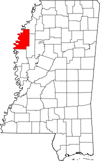 | |
| Towns | ||
| Unincorporated communities | ||
| Ghost towns | ||
| Footnotes | ‡This populated place also has portions in an adjacent county or counties | |
This article is issued from
Wikipedia.
The text is licensed under Creative Commons - Attribution - Sharealike.
Additional terms may apply for the media files.