Chott el Hodna
| Chott el Hodna شط الحضنة | |
|---|---|
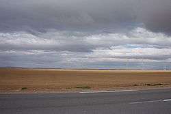 Landscape of the Chott el Hodna | |
| Location | Hodna |
| Coordinates | 35°26′N 4°46′E / 35.44°N 4.76°ECoordinates: 35°26′N 4°46′E / 35.44°N 4.76°E |
| Type | Endorheic salt lake |
| Basin countries | Algeria |
| Max. length | 77 km (48 mi) |
| Max. width | 16 km (9.9 mi) |
| Surface area | 76,000 ha (190,000 acres) |
| Surface elevation | 394 m (1,293 ft) above sea level |
| Designated | 2 February 2001 |
| Reference no. | 1053[1] |
The Chott el Hodna (Arabic: شط الحضنة) is a very shallow saline lake in Algeria. It is located within an endorheic basin in the Hodna region, towards the eastern end of the Hautes Plaines.[2] The Chott el Hodna includes seasonal brackish and saline pools and marshes, but the central zone of the lake is characterized by a complete absence of vegetation.
J. Despois argues that the Chott el Hodna is not a proper Chott, but a Sebkha.[3]
Ecology
The chott area provides an important habitat for certain endangered species such as the Cuvier's gazelle, the marbled duck and different kinds of bustards, as well as indigenous fish species. The Chott el Hodna was declared a Ramsar site on 2 February 2001.[4]
See also
References
- ↑ "Chott El Hodna". Ramsar Sites Information Service. Retrieved 25 April 2018.
- ↑ "Chott el-Hodna (lake, Algeria)". Encyclopædia Britannica. Retrieved 21 June 2013.
- ↑ J. Despois, Le Hodna (Algérie)
- ↑ The Annotated Ramsar List: Algeria
External links
- Mohamed Meouak, Le Hodna occidental entre régions méditerranéennes et plaines désertiques : organisation des terroirs, communautés rurales et productions agricoles au Moyen Âge
- Introduction: Les hautes plaines de l'Est de l'Algérie
This article is issued from
Wikipedia.
The text is licensed under Creative Commons - Attribution - Sharealike.
Additional terms may apply for the media files.