Shah Amanat International Airport
| Shah Amanat International Airport শাহ আমানত আন্তর্জাতিক বিমানবন্দর | |||||||||||
|---|---|---|---|---|---|---|---|---|---|---|---|
 | |||||||||||
| Summary | |||||||||||
| Airport type | Public, military | ||||||||||
| Owner | Bangladesh government | ||||||||||
| Operator | Civil Aviation Authority of Bangladesh | ||||||||||
| Serves | Chittagong, Bangladesh | ||||||||||
| Location | Patenga | ||||||||||
| Focus city for | |||||||||||
| Elevation AMSL | 12 ft / 4 m | ||||||||||
| Coordinates | 22°14′59″N 91°48′48″E / 22.24972°N 91.81333°ECoordinates: 22°14′59″N 91°48′48″E / 22.24972°N 91.81333°E | ||||||||||
| Website |
chittagongairport | ||||||||||
| Map | |||||||||||
 CGP Location of airport in Bangladesh | |||||||||||
| Runways | |||||||||||
| |||||||||||
|
Source: Civil Aviation Authority of Bangladesh[1] | |||||||||||
Shah Amanat International Airport (IATA: CGP, ICAO: VGEG) (Bengali: শাহ আমানত আন্তর্জাতিক বিমানবন্দর Shah Amanôt Antôrjatik Bimanbôndôr) is an international airport serving Bangladesh's southeastern port city of Chittagong. Operated and maintained by the Civil Aviation Authority of Bangladesh, it is the second-largest international airport in Bangladesh after Shahjalal International Airport in Dhaka, Bangladesh. It is used by the Bangladesh Air Force as a part of 'BAF Zahurul Haq Base'. It was formerly known as MA Hannan International Airport, named after Awami League politician M. A. Hannan, but was renamed on 2 April 2005 by the Government of Bangladesh, after an Islamic saint, Hazrat Shah Amanat. It is capable of annually handling 1.5 million passengers and 6,000 tonnes of cargo.[2]
Location
The airport is in the Patenga area of the city, 20 kilometres (13 mi; 11 NM) west from the city's main commercial hub, GEC Circle and 18.5 km south of the city's railway station on the north bank of the Karnaphuli River. There are no hotels or restaurants near the airport; numerous hotels and restaurants are available in the city.
History
World War II
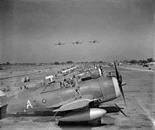
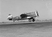
The airfield was built in the early 1940s under the British rule. Known as Chittagong Airfield during World War II, it was used as a combat airfield, as well as a supply point and photographic reconnaissance base by the United States Army Air Forces' Tenth Air Force during the Burma Campaign 1944-1945.[3]
Known American units assigned to Chittagong were:
- 80th Fighter Group, flew P-38 Lightning fighters over Burma between March 1944 and February 1945
- 8th Reconnaissance Group, between October and December 1944 (various detachments)
- 4th Combat Cargo Group, flew C-46 Commando transports between January and June 1945
From the airport, the 4th CCG C-46s flew supplies and ammunition which were air-dropped to the advancing Allied forces on the ground. At the end of June, control of the airport was returned to local authorities.
Bangladeshi airport
It officially became a Bangladeshi airport in 1972 after Bangladesh's liberation war.[4] At first, it was mainly used for connecting Dhaka and Chittagong. But in the mid-1990s Biman started international flights to Bangkok, Dubai and all other major Gulf cities and it officially became an international airport.
Expansion since 1998
In March 1998, a major renovation and expansion began, which ended in December 2000.[4] CAAB received financial assistance from the Japan International Cooperation Agency for the US$51.57 million upgrade.[4] The project was carried out by Japanese firms Shimizu and Marubeni.[4] The upgrade modernised the terminal with new and better seats, more check-in counters, better security equipment and other facilities.[4] The Air Traffic Control tower received new hi-tech equipment such as 3D radar. The runway, taxiways and the tarmac were expanded and improved.[4] After the upgrade, aircraft such as the Boeing 747-400 or the Airbus A340 can land easily.[4]
In June 2005, CAAB announced that the management of the airport would be awarded to Thai Airways, the national carrier of Thailand, for 10 years.[2] Thai Airways would be responsible of catering, passenger check-in, ground handling, cargo handling, and other technical services.[5]
Emirates SkyCargo launched cargo services in 2013, making it the first scheduled cargo airline in the airport.[6]
Infrastructure and operation
Terminal
The airport's sole 220,000 square feet (20,000 m2) passenger terminal is divided into two parts: International and Domestic with a boarding bridge in each.[4] The International part of the terminal is larger than the Domestic one due to higher number of passengers.[4] The building is divided into two floors: The lower floor is used for checking in, boarding or getting off small planes, and receiving luggage. The upper floor is used for boarding or getting off large planes only.[4]
The airport also has a 29,063 square feet (2,700 m2) cargo terminal.[4]
Control tower
The air traffic control tower is 50 meters west of the airport terminal. It has a clear view of the tarmac and taxiways but is far from the runway. Heavy rain or fog can make it difficult for controllers to see planes taking off or landing.
Runway
The airport has a single runway (05/23), which is 2,940 m × 45 m (9,646 ft × 148 ft).[4] The largest aircraft that can land is a Boeing 747-400.[4]
Taxiways and tarmac
The airport has two taxiways, Alpha and Bravo, that directly leads to the tarmac (or aircraft parking zone) from the runway. The tarmac can accommodate a maximum of four aircraft; two wide-body Boeing 747-400s, a wide-body McDonnell Douglas DC-10 and a narrow-body Airbus A320 can be parked there at once.[4] The airport has two boarding bridges and two passenger steps. The parking points are usually empty as most of the planes that arrive there take off soon after; the planes of local airlines are generally parked at Shahjalal International Airport overnight. A small civil plane hangar belonging to Biman is available but is rarely used.
The Bangladesh Military has a parking zone and two plane hangars east of the runway. The Bangladesh Air Force store a few planes here which have direct access to the runway.
Airlines and destinations
Passenger
Cargo
| Airlines | Destinations |
|---|---|
| Emirates Sky Cargo | Dubai-Al Maktoum, Hanoi |
| Etihad Crystal Cargo | Abu Dhabi, Guangzhou, Hong Kong |
Ground transportation
Shah Amanat International Airport can be easily accessed by car or taxi thorough the city's Agrabad area. It has three parking zones: one civil and two VIP. The civil one is in front of the terminal; it has a capacity of 400 cars.[4] This zone is usually loaded with public transport, mostly auto-rickshaws and micro-buses. The zone is made of concrete and asphalt, surrounded by a grass patch. Both VIP parking zones are beside the terminal, one left and one right. The one on the left is for people who work at the airport or one of the airlines, such as pilots or air traffic controllers. The other is used by the VVIPs.
Incidents and accidents
- 1 July 2005: Biman flight BG 048 en route from Dubai skidded off runway 23 onto the grass while landing during heavy rain. The right-hand undercarriage of the McDonnell Douglas DC-10-30 caught fire. Ten passengers were injured while exiting. Investigations found that the wheel-box of the aircraft went out of order. The aircraft was later written-off.[7]
- 3 August 2017: A Bangladesh Navy Dornier Do 228 aircraft on a routine training exercise veered off runway 23 after landing. No crew members were injured during the incident. The airport was closed for about 3 hours; a Cessna 152 training aircraft landed safely on the opposite runway few minutes after the incident.
- 26 September 2018: A US-Bangla Airlines Boeing 737NG aircraft bound for Cox's Baxar from Dhaka was forced to make an emergency landing when the pilots had difficulty in trying to lower the front main nose-gear. The airline carrying 171 passengers and crew, made an emergency landing at Chittagong, Shah Amanat International Airport at 1:45 pm local time. [8] No injuries and fatalities occurred as the flight crew, was able to evacuate the entire plane as emergency services rushed to the scene.
References
![]()
- ↑ "Aerodrome Information: Shah Amanat International Airport, Chittagong". Civil Aviation Authority of Bangladesh. Archived from the original on 4 March 2016.
- 1 2 "SAIA needs proper facilities to harness it's [sic] potential & to get out of trouble". Bangladesh Monitor. Archived from the original on 2 February 2014. Retrieved 20 January 2014.
- ↑ Maurer, Maurer. Air Force Combat Units of World War II. Maxwell Air Force Base, Alabama: Office of Air Force History, 1983. ISBN 0-89201-092-4
- 1 2 3 4 5 6 7 8 9 10 11 12 13 14 15 "Chittagong Airport Development Project". Civil Aviation Authority of Bangladesh. Retrieved 22 November 2013.
- ↑ "Thai Airways International to manage Chittagong Airport". ASIATravelTips.com. 2 July 2005. Retrieved 20 January 2014.
- ↑ "Emirates SkyCargo commences dedicated freighter to Chittagong". Bangladesh Monitor. 1 February 2013. Archived from the original on 29 October 2013. Retrieved 2 February 2013.
- ↑ "Biman escapes possible crash-landing in Chittagong". 9 July 2007. Retrieved 22 April 2013.
- ↑ https://www.thedailystar.net/city/news/us-bangla-plane-makes-emergency-landing-chattogram-airport-1638949
External links
![]()
- Airport information for VGEG at World Aero Data. Data current as of October 2006.
- Civil Aviation Authority of Bangladesh: Airports
- Live Flight Status
| Airfields |
| .png) | |||||||||||||||
|---|---|---|---|---|---|---|---|---|---|---|---|---|---|---|---|---|---|
| Units |
| ||||||||||||||||