Chenango Forks, New York
| Chenango Forks, New York | |
|---|---|
| Hamlet | |
 Chenango Forks | |
| Coordinates: 42°14′08″N 75°50′54″W / 42.23556°N 75.84833°WCoordinates: 42°14′08″N 75°50′54″W / 42.23556°N 75.84833°W | |
| Country | United States |
| State | New York |
| County | Broome |
| Towns | Chenango, Barker |
| Elevation | 915 ft (279 m) |
| Time zone | UTC-5 (Eastern (EST)) |
| • Summer (DST) | UTC-4 (EDT) |
| Area code(s) | 607 |
| GNIS feature ID | 946482[1] |
Chenango Forks is a hamlet located in Broome County, New York in the United States.[1] The community is partly in the town of Chenango and partly in the town of Barker.
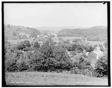
Chenango Forks in the early 1900s
Chenango Forks is about 9 miles (14 km) north of Binghamton on Route 12 and is at the confluence of the Chenango River and Tioughnioga River. Chenango Valley State Park is southwest of the hamlet. Chenango Forks is a few miles from the border of Chenango County, New York.
Chenango Forks is part of the Greater Binghamton Metropolitan Statistical Area.
The Chenango Canal Prism and Lock 107 was listed on the National Register of Historic Places in 2010.[2]
References
- 1 2 "Chenango Forks". Geographic Names Information System. United States Geological Survey.
- ↑ National Park Service (2009-03-13). "National Register Information System". National Register of Historic Places. National Park Service.
Municipalities and communities of Broome County, New York, United States | ||
|---|---|---|
| City | 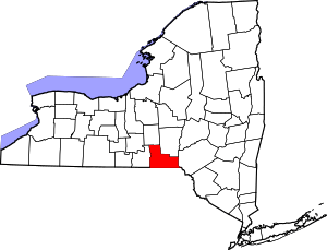 | |
| Towns | ||
| Villages | ||
| CDPs | ||
| Other hamlets | ||
| Footnotes | ‡This populated place also has portions in an adjacent county or counties | |
This article is issued from
Wikipedia.
The text is licensed under Creative Commons - Attribution - Sharealike.
Additional terms may apply for the media files.