Chavies, Kentucky
| Chavies | |
|---|---|
| Unincorporated community | |
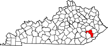
 Chavies Location within the state of Kentucky  Chavies Chavies (the US) | |
| Coordinates: 37°20′52″N 83°21′23″W / 37.34778°N 83.35639°WCoordinates: 37°20′52″N 83°21′23″W / 37.34778°N 83.35639°W | |
| Country | United States |
| State | Kentucky |
| County | Perry |
| Elevation | 801 ft (244 m) |
| Time zone | UTC-5 (Eastern (EST)) |
| • Summer (DST) | UTC-4 (EDT) |
| ZIP codes | 41727 |
| GNIS feature ID | 511319[1] |
Chavies is a residential hamlet with a U.S. Post Office located in Perry County, Kentucky, United States.[2]
References
This article is issued from
Wikipedia.
The text is licensed under Creative Commons - Attribution - Sharealike.
Additional terms may apply for the media files.