Chapel Hill, Covington County, Alabama
| Chapel Hill, Alabama | |
|---|---|
| Unincorporated community | |
 Chapel Hill, Alabama  Chapel Hill, Alabama | |
| Coordinates: 31°01′46″N 86°13′52″W / 31.02944°N 86.23111°WCoordinates: 31°01′46″N 86°13′52″W / 31.02944°N 86.23111°W | |
| Country | United States |
| State | Alabama |
| County | Covington |
| Elevation | 230 ft (70 m) |
| Time zone | UTC-6 (Central (CST)) |
| • Summer (DST) | UTC-5 (CDT) |
| ZIP code | 36442 |
| Area code(s) | 334 |
| GNIS feature ID | 1730327[1] |
Chapel Hill is an unincorporated community in Covington County, Alabama, United States, located on State Route 54, northeast of Florala.
References
Municipalities and communities of Covington County, Alabama, United States | ||
|---|---|---|
| Cities | 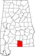 | |
| Towns | ||
| Unincorporated community | ||
This article is issued from
Wikipedia.
The text is licensed under Creative Commons - Attribution - Sharealike.
Additional terms may apply for the media files.