Babbie, Alabama
| Babbie, Alabama | |
|---|---|
| Town | |
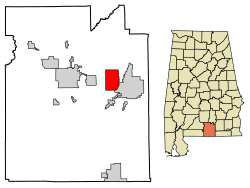 Location of Babbie in Covington County, Alabama. | |
| Coordinates: 31°18′1″N 86°19′9″W / 31.30028°N 86.31917°W | |
| Country | United States |
| State | Alabama |
| County | Covington |
| Area[1] | |
| • Total | 11.59 sq mi (30.01 km2) |
| • Land | 11.47 sq mi (29.71 km2) |
| • Water | 0.12 sq mi (0.30 km2) |
| Elevation | 259 ft (79 m) |
| Population (2010) | |
| • Total | 603 |
| • Estimate (2017)[2] | 599 |
| • Density | 52.22/sq mi (20.16/km2) |
| Time zone | UTC-6 (Central (CST)) |
| • Summer (DST) | UTC-5 (CDT) |
| FIPS code | 01-03556 |
| GNIS feature ID | 0113321 |
Babbie is a town in Covington County, Alabama, United States. At the 2010 census the population was 603.[3] It incorporated in 1957.[4]
Geography
Babbie is located in eastern Covington County at 31°18′2″N 86°19′9″W / 31.30056°N 86.31917°W (31.300460, -86.319293).[5] It is bordered to the east by the city of Opp.
According to the U.S. Census Bureau, the town has a total area of 11.6 square miles (30.0 km2), of which 11.5 square miles (29.7 km2) is land and 0.12 square miles (0.3 km2), or 1.01%, is water.[3]
Demographics
| Historical population | |||
|---|---|---|---|
| Census | Pop. | %± | |
| 1960 | 60 | — | |
| 1970 | 82 | 36.7% | |
| 1980 | 553 | 574.4% | |
| 1990 | 576 | 4.2% | |
| 2000 | 627 | 8.9% | |
| 2010 | 603 | −3.8% | |
| Est. 2017 | 599 | [2] | −0.7% |
| U.S. Decennial Census[6] 2013 Estimate[7] | |||
2000 Census data
As of the census[8] of 2000, there were 627 people, 258 households, and 192 families residing in the town. The population density was 54.3 people per square mile (21.0/km2). There were 284 housing units at an average density of 24.6 per square mile (9.5/km2). The racial makeup of the town was 98.88% White, 0.16% Black or African American, 0.32% Asian, 0.16% from other races, and 0.48% from two or more races.
There were 258 households out of which 29.1% had children under the age of 18 living with them, 64.0% were married couples living together, 8.9% had a female householder with no husband present, and 25.2% were non-families. 23.6% of all households were made up of individuals and 7.8% had someone living alone who was 65 years of age or older. The average household size was 2.43 and the average family size was 2.87.
In the town, the population was spread out with 22.3% under the age of 18, 7.8% from 18 to 24, 30.1% from 25 to 44, 25.5% from 45 to 64, and 14.2% who were 65 years of age or older. The median age was 39 years. For every 100 females, there were 101.6 males. For every 100 females age 18 and over, there were 94.8 males.
The median income for a household in the town was $26,328, and the median income for a family was $31,875. Males had a median income of $27,054 versus $17,000 for females. The per capita income for the town was $13,628. About 16.6% of families and 14.8% of the population were below the poverty line, including 21.6% of those under age 18 and 15.6% of those age 65 or over.
References
- ↑ "2017 U.S. Gazetteer Files". United States Census Bureau. Retrieved Jul 7, 2018.
- 1 2 "Population and Housing Unit Estimates". Retrieved March 24, 2018.
- 1 2 "Geographic Identifiers: 2010 Demographic Profile Data (G001): Babbie town, Alabama". U.S. Census Bureau, American Factfinder. Retrieved June 10, 2014.
- ↑ http://alabamamaps.ua.edu/historicalplaces/text/CovingtonText.pdf
- ↑ "US Gazetteer files: 2010, 2000, and 1990". United States Census Bureau. 2011-02-12. Retrieved 2011-04-23.
- ↑ "U.S. Decennial Census". Census.gov. Archived from the original on May 12, 2015. Retrieved June 6, 2013.
- ↑ "Annual Estimates of the Resident Population: April 1, 2010 to July 1, 2013". Retrieved June 3, 2014.
- ↑ "American FactFinder". United States Census Bureau. Archived from the original on 2013-09-11. Retrieved 2008-01-31.
Coordinates: 31°18′02″N 86°19′09″W / 31.30046°N 86.319293°W
Municipalities and communities of Covington County, Alabama, United States | ||
|---|---|---|
| Cities | 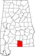 | |
| Towns | ||
| Unincorporated community | ||