Beda, Alabama
| Beda, Alabama | |
|---|---|
| Unincorporated community | |
 Beda, Alabama  Beda, Alabama | |
| Coordinates: 31°03′04″N 86°34′58″W / 31.05111°N 86.58278°WCoordinates: 31°03′04″N 86°34′58″W / 31.05111°N 86.58278°W | |
| Country | United States |
| State | Alabama |
| County | Covington |
| Elevation | 246 ft (75 m) |
| Time zone | UTC-6 (Central (CST)) |
| • Summer (DST) | UTC-5 (CDT) |
| Area code(s) | 334 |
| GNIS feature ID | 156042[1] |
Beda is an unincorporated community in Covington County, Alabama, United States. Beda is located on Alabama State Route 137, 18.2 miles (29.3 km) south-southeast of Andalusia. The community lies entirely within the Conecuh National Forest.
History
A post office operated under the name Beda from 1886 to 1897.[2]
References
- ↑ "Beda". Geographic Names Information System. United States Geological Survey.
- ↑ "Covington County". Jim Forte Postal History. Retrieved 25 December 2015.
Municipalities and communities of Covington County, Alabama, United States | ||
|---|---|---|
| Cities | 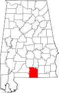 | |
| Towns | ||
| Unincorporated community | ||
This article is issued from
Wikipedia.
The text is licensed under Creative Commons - Attribution - Sharealike.
Additional terms may apply for the media files.