Cervera del Maestre
| Cervera del Maestre Cervera del Maestrat | ||
|---|---|---|
| Municipality | ||
 | ||
| ||
 Cervera del Maestre Location in Spain | ||
| Coordinates: 40°27′14″N 0°16′31″E / 40.45389°N 0.27528°ECoordinates: 40°27′14″N 0°16′31″E / 40.45389°N 0.27528°E | ||
| Country |
| |
| Autonomous community |
| |
| Province | Castelló | |
| Comarca | Baix Maestrat | |
| Judicial district | Vinaròs | |
| Area | ||
| • Total | 93.2 km2 (36.0 sq mi) | |
| Elevation | 313 m (1,027 ft) | |
| Population (2016) | ||
| • Total | 642 | |
| • Density | 6.9/km2 (18/sq mi) | |
| Demonym(s) | Cerverí, cerverina | |
| Time zone | UTC+1 (CET) | |
| • Summer (DST) | UTC+2 (CEST) | |
| Postal code | 12578 | |
| Official language(s) | Valencian | |

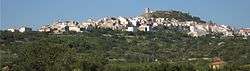
Cervera del Maestre (Valencian: Cervera del Maestrat) is a municipality in the comarca of Baix Maestrat in the Valencian Community, Spain. It is located at the southern end of the Cervera Mountains, above the Rambla de Cervera seasonal river.
Cervera is located on a hill with a ruined Moorish castle top of it. It lies in an area of maquis shrub and cultivated plots, mainly almond, carob and olive trees.[1] There is a ruined ermita south of the town.
Cervera del Maestre is part of the Taula del Sénia free association of municipalities.

Entrance to the castle on top of the hill
References
External links
| Wikimedia Commons has media related to Cervera del Maestrat. |
- Cervera del Maestre
- Casa del dragon, artist residence
- Paco González Ramírez - País Valencià, poble a poble, comarca a comarca
- Institut Valencià d'Estadística.
- Portal de la Direcció General d'Administració Local de la Generalitat.
- [http://www.cerveradelmaestre.org/images/Boletin/BIM5.pdf Butlletí d’Informació Municipal]
Municipalities of Baix Maestrat | ||
|---|---|---|
This article is issued from
Wikipedia.
The text is licensed under Creative Commons - Attribution - Sharealike.
Additional terms may apply for the media files.