Central Owenton Historic District
|
Central Owenton Historic District | |
 | |
 Location in Kentucky  Location in United States | |
| Location | Roughly Bryan, Madison, Seminary, and Thomas Sts., Owenton, Kentucky |
|---|---|
| Coordinates | 38°32′10″N 84°50′14″W / 38.53611°N 84.83722°WCoordinates: 38°32′10″N 84°50′14″W / 38.53611°N 84.83722°W |
| Area | 4 acres (1.6 ha) |
| Built | 1890 |
| Architect | Multiple |
| MPS | Owenton MRA |
| NRHP reference # | 84001893[1] |
| Added to NRHP | September 4, 1984 |
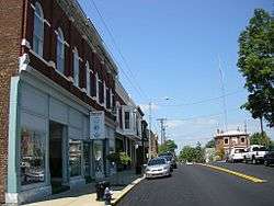
The Central Owenton Historic District in Owenton, Kentucky is a 4 acres (1.6 ha) historic district which was listed on the National Register of Historic Places in 1984. The listing included 18 contributing buildings.[1]
It included the Owen County Courthouse and Jail, which were already separately listed on the National Register.[2]
The district includes roughly Bryan, Madison, Seminary, and Thomas Streets.[2]
References
- 1 2 National Park Service (2013-11-02). "National Register Information System". National Register of Historic Places. National Park Service.
- 1 2 "National Register of Historic Places Inventory/Nomination: Historic Resources of Owenton: Central Owenton Historic District". National Park Service. Retrieved May 3, 2018. Includes numerous Kentucky Historic Resources Inventory forms for various buildings. With accompanying 11 photos from 1984
| Topics | |
|---|---|
| Lists by states |
|
| Lists by insular areas | |
| Lists by associated states | |
| Other areas | |
| |
This article is issued from
Wikipedia.
The text is licensed under Creative Commons - Attribution - Sharealike.
Additional terms may apply for the media files.