Cedarock Park
| Cedarock Park | |
| "Historic Nature Wonderland" | |
| Protected area | |
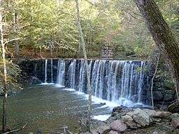 Old Mill Dam on Rock Creek | |
| Name origin: Large number of rocks and cedar trees in park | |
| Country | United States |
|---|---|
| State | North Carolina |
| County | Alamance County |
| Cities | Four miles south of Burlington, near Bellemont |
| Elevation | 539 ft (164 m) |
| Coordinates | 35°59′41.36″N 79°26′24.15″W / 35.9948222°N 79.4400417°WCoordinates: 35°59′41.36″N 79°26′24.15″W / 35.9948222°N 79.4400417°W |
| Highest point | Obel's Shelter |
| - elevation | 605 ft (184 m) |
| - coordinates | 35°59′21.77″N 79°26′54.68″W / 35.9893806°N 79.4485222°W |
| Lowest point | Rock Creek |
| - location | On Rock Creek just past Persimmon Creek |
| - elevation | 491 ft (150 m) |
| - coordinates | 35°59′58.96″N 79°26′25.23″W / 35.9997111°N 79.4403417°W |
| Area | 0.65 sq mi (2 km2) |
| Geology | Sedimentary |
| Plants | Loblolly pine, eastern white pine, eastern red cedar |
| Animals | Wild turkey, American black bear, black rat snake, North American beaver |
| Founded | 1973 |
| Management | Alamance County Recreation and Parks |
| - location | County Government |
| Visitation | 140,000 |
| IUCN category | II - National Park |
 Location of Cedarock Park in North Carolina | |
Cedarock Park is a 414-acre (1.68 km2) nature preserve, historic farm, and passive-use park located near Bellemont in Alamance County, North Carolina.
Geographic setting
Cedarock Park sits on the banks of Rock Creek, a tributary of Great Alamance Creek on the northwestern side of the Cane Creek Mountains. Located in the Piedmont region of North Carolina, the land is hilly and occasionally steep.
Human history
Prior to its use as a park, the land was used as a farm by the Garrett family beginning in 1830.[1] The site of the Garrett farm is part of the Cedarock Park Historic District and is known as Cedarock Historic Farm, an educational site where visitors can learn about farm life in 19th-century North Carolina and can encounter goats and donkeys.
Activities
The park has 6 miles (9.7 km) of trails for hiking, mountain biking, and horse riding, including some trails that are handicapped accessible. It has numerous picnic shelters, campsites, a fishing pond, playgrounds, three gazebos, and two courses.[2]
The most popular trail at the park is the handicapped-accessible trail that leads to an old rock dam used for water diversion for a now-demolished gristmill. The dam site is erroneously called a waterfall in several places in park literature.
References
- ↑ Farm History – Alamance County Archived 2011-06-08 at the Wayback Machine.. Alamance-nc.com (2010-05-03). Retrieved on 2010-12-25.
- ↑ Cedarock Park – Alamance County Archived 2010-12-03 at the Wayback Machine.. Alamance-nc.com (2010-11-18). Retrieved on 2010-12-25.