Catawba Island Township, Ottawa County, Ohio
| Catawba Island Township, Ottawa County, Ohio | |
|---|---|
| Township | |
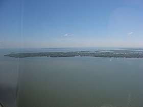 Aerial view of Catawba Island from the west | |
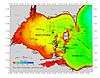
 Location of Catawba Island Township in Ottawa County. | |
| Coordinates: 41°33′49″N 82°50′20″W / 41.56361°N 82.83889°WCoordinates: 41°33′49″N 82°50′20″W / 41.56361°N 82.83889°W | |
| Country | United States |
| State | Ohio |
| County | Ottawa |
| Area | |
| • Total | 16.9 sq mi (43.8 km2) |
| • Land | 5.7 sq mi (14.8 km2) |
| • Water | 11.2 sq mi (29.1 km2) |
| Elevation[1] | 581 ft (177 m) |
| Population (2000) | |
| • Total | 3,157 |
| • Density | 554.0/sq mi (213.9/km2) |
| Time zone | UTC-5 (Eastern (EST)) |
| • Summer (DST) | UTC-4 (EDT) |
| ZIP code | 43452 |
| Area code(s) | 419 |
| FIPS code | 39-12588[2] |
| GNIS feature ID | 1086758[1] |
| Website | http://www.catawbaislandtownship.com/ |
Catawba Island Township is one of the twelve townships of Ottawa County, Ohio, United States. The 2000 census found 3,157 people in the township.[3]
Communities
- Catawba Island is an unincorporated community located in the Northern portion of the Township and the Northern portion of the Catawba Island Peninsula. The Catawba Island ferry terminal is located within the unincorporated community, the Miller Ferry runs from the terminal to the Put-in-Bay ferry terminal and the Middle Bass ferry terminal. The Catawba Island Nature Preserve is also located within the unincorporated community.
Geography
The township is located in the northeastern part of the county on the northern point of the Marblehead Peninsula, presently forming its own peninsula into Lake Erie — but formerly, it was an actual 'island'. It borders the following townships:
- Put-in-Bay Township - north, across Lake Erie
- Kelleys Island - northeast, across Lake Erie
- Danbury Township - southeast
- Portage Township - southwest
No municipalities are located in Catawba Island Township.
Name and history
It is the only Catawba Island Township statewide. The township's website claims that it was named for the variety of grapes that grew plentifully there,[4] however, another source claims that it is named for the Catawba tribe, who once lived in the Carolinas.[5]
Although currently not an actual 'island', it is presently a peninsula. But in prehistoric times, the Portage River is thought to have flowed into Lake Erie at the 'West Harbor' (near East Harbor State Park) — and this old channel of the river (which was also denoted on 19th-century maps) formerly made Catawba into a true island; but all that currently remains of most of the old riverbed, is an insignificant ditch.[6] Prior to about 1804, the British seem to have referred to this island as named 'Cunningham's Island'[7] (but, shortly later, that name, "Cunningham's", seems to have been briefly transferred to present-day Kelley's Island, which had formerly been named "Sandusky Island" in the 18th-century).
A large section of this township is within the Firelands region (the westernmost area of the Connecticut Western Reserve), and was originally a part of 'Danbury Township'.
Government
The township is governed by a three-member board of trustees, who are elected in November of odd-numbered years to a four-year term beginning on the following January 1. Two are elected in the year after the presidential election and one is elected in the year before it. There is also an elected township fiscal officer,[8] who serves a four-year term beginning on April 1 of the year after the election, which is held in November of the year before the presidential election. Vacancies in the fiscal officership or on the board of trustees are filled by the remaining trustees.
Tourism and Recreation
Catawba Island is a very popular summer destination. The long and protected shoreline provides multiple marinas and cottage communities. The Lake Erie Islands including the Bass Islands, Kelleys, and Pelee are all easily accessible. The Miller Ferry which is able to carry cars, trucks, and pedestrians to and from the islands operates off the tip of the peninsula.
References
- 1 2 "US Board on Geographic Names". United States Geological Survey. 2007-10-25. Retrieved 2008-01-31.
- ↑ "American FactFinder". United States Census Bureau. Archived from the original on 2013-09-11. Retrieved 2008-01-31.
- ↑ Ottawa County, Ohio — Population by Places Estimates Ohio State University, 2007. Accessed 15 May 2007.
- ↑ Catawba Island Township Historical Information
- ↑ Catawba Orientation
- ↑ Catawba Island, the Great Peach Growing Center of Ohio
- ↑ A short topographical description of His Majesty's province of Upper Canada in North America to which is annexed a provincial gazetteer, by Sir David Wm. Smyth, publ 1799
- ↑ §503.24, §505.01, and §507.01 of the Ohio Revised Code. Accessed 4/30/2009.
External links
| Wikivoyage has a travel guide for Catawba Island. |
Municipalities and communities of Ottawa County, Ohio, United States | ||
|---|---|---|
| City | 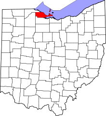 | |
| Villages | ||
| Townships | ||
| CDPs | ||
| Unincorporated communities | ||
| Footnotes | ‡This populated place also has portions in an adjacent county or counties | |