Allen Township, Ottawa County, Ohio
| Allen Township, Ottawa County, Ohio | |
|---|---|
| Township | |
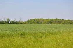 Fields west of Clay Center | |
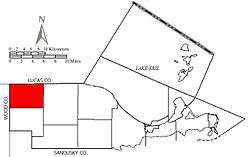 Location of Allen Township in Ottawa County. | |
| Coordinates: 41°35′46″N 83°21′47″W / 41.59611°N 83.36306°WCoordinates: 41°35′46″N 83°21′47″W / 41.59611°N 83.36306°W | |
| Country | United States |
| State | Ohio |
| County | Ottawa |
| Area | |
| • Total | 25.3 sq mi (65.4 km2) |
| • Land | 25.3 sq mi (65.4 km2) |
| • Water | 0.0 sq mi (0.0 km2) |
| Elevation[1] | 604 ft (184 m) |
| Population (2000) | |
| • Total | 3,591 |
| • Density | 142.2/sq mi (54.9/km2) |
| Time zone | UTC-5 (Eastern (EST)) |
| • Summer (DST) | UTC-4 (EDT) |
| FIPS code | 39-01322[2] |
| GNIS feature ID | 1086754[1] |
Allen Township is one of the twelve townships of Ottawa County, Ohio, United States. The 2000 census found 3,591 people in the township, 3,297 of whom lived in the unincorporated portions of the township.[3]
Geography
Located in the northwestern corner of the county, it borders the following townships and cities:
- Jerusalem Township, Lucas County - north
- Benton Township - east
- Clay Township - south
- Lake Township, Wood County - west
- Northwood - northwest, south of Oregon
- Oregon - northwest, north of Northwood
The village of Clay Center is located in the southern part of the township, and the unincorporated communities of Curtice and Williston lie in the township's north.
Name and history
Statewide, other Allen Townships are located in Darke, Hancock, and Union counties.[4]
Government
The township is governed by a three-member board of trustees, who are elected in November of odd-numbered years to a four-year term beginning on the following January 1. Two are elected in the year after the presidential election and one is elected in the year before it. There is also an elected township fiscal officer,[5] who serves a four-year term beginning on April 1 of the year after the election, which is held in November of the year before the presidential election. Vacancies in the fiscal officership or on the board of trustees are filled by the remaining trustees.
References
- 1 2 "US Board on Geographic Names". United States Geological Survey. 2007-10-25. Retrieved 2008-01-31.
- ↑ "American FactFinder". United States Census Bureau. Archived from the original on 2013-09-11. Retrieved 2008-01-31.
- ↑ Ottawa County, Ohio — Population by Places Estimates Ohio State University, 2007. Accessed 15 May 2007.
- ↑ "Detailed map of Ohio" (PDF). United States Census Bureau. 2000. Retrieved 2007-02-16.
- ↑ §503.24, §505.01, and §507.01 of the Ohio Revised Code. Accessed 4/30/2009.
External links
Municipalities and communities of Ottawa County, Ohio, United States | ||
|---|---|---|
| City |  | |
| Villages | ||
| Townships | ||
| CDPs | ||
| Unincorporated communities | ||
| Footnotes | ‡This populated place also has portions in an adjacent county or counties | |