Castle Rock, Tillamook County, Oregon
| Castle Rock | |
|---|---|
| Unincorporated locale | |
 Castle Rock Location within the state of Oregon  Castle Rock Castle Rock (the US) | |
| Coordinates: 45°10′47″N 123°49′14″W / 45.17972°N 123.82056°WCoordinates: 45°10′47″N 123°49′14″W / 45.17972°N 123.82056°W | |
| Country | United States |
| State | Oregon |
| County | Tillamook |
| Time zone | UTC-8 (Pacific (PST)) |
| • Summer (DST) | UTC-7 (PDT) |
| GNIS feature ID | 1153491[1] |
Castle Rock is an unincorporated community in Tillamook County, Oregon, United States.[1] It is located in the Northern Oregon Coast Range within the Siuslaw National Forest on Oregon Route 22 near Three Rivers. The nearest major community is Hebo.[2] Castle Rock has an elevation of 272 feet (83 m).[3]
References
- 1 2 "Castle Rock, Tillamook County, Oregon". Geographic Names Information System. United States Geological Survey.
- ↑ "Castlerock Lodge USGS Hebo Quad, Oregon, Topographic Map". Retrieved 2009-03-05.
- ↑ "Topographic Map Locale Features in Tillamook County, Oregon". Retrieved 2009-03-05.
Municipalities and communities of Tillamook County, Oregon, United States | ||
|---|---|---|
| Cities | 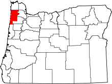 | |
| CDPs | ||
| Unincorporated communities | ||
This article is issued from
Wikipedia.
The text is licensed under Creative Commons - Attribution - Sharealike.
Additional terms may apply for the media files.