Castillo de Teayo (municipality)
| Castillo de Teayo | |
|---|---|
| Municipality | |
 Archaeological site | |
|
Castillo de Teayo Location in Mexico | |
| Coordinates: 20°45′0″N 97°38′0″W / 20.75000°N 97.63333°WCoordinates: 20°45′0″N 97°38′0″W / 20.75000°N 97.63333°W | |
| Country |
|
| State | Veracruz |
| Municipal seat | Castillo de Teayo |
| Municipality created | 13 December 1877[1] |
| Government | |
| • Municipal President | Martin Rafael Rodríguez González (2008-10) |
| Area | |
| • Total | 447.46 km2 (172.77 sq mi) |
| Elevation | 80 m (260 ft) |
| Population (2005) | |
| • Total | 18,424 |
| • Density | 41/km2 (110/sq mi) |
| Website | Castillo de Teayo |
Castillo de Teayo Municipality is one of the 212 municipalities of the Mexican state of Veracruz. It is located in the state's Huasteca Baja region. The municipal seat is the village of Castillo de Teayo.
In the 2005 INEGI Census, the municipality reported a total population of 18,424 (down from 19,335 in 1995), of whom 4,159 lived in the municipal seat.[2] Of the municipality's inhabitants, 1,970 (10.52%) spoke an indigenous language, primarily Nahuatl.
The municipality of Castillo de Teayo covers a total surface area of 447.46 km².
Name
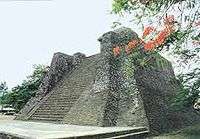
"Teayo" comes from the Nahuatl te-ayo-k, which means "tortoise atop stone". This is a reference to the archaeological site known as the Castle of Teayo, a syncretic blend of the Toltec, Mexica, and Huastec cultures
Settlements
- Castillo de Teayo (municipal seat; 2005 population 4159)
- Mequetla (1614)
- La Guadalupe (1504)
- Teayo (1402)
- La Defensa (1117)
References
- ↑ "Castillo y su historia". Municipio de Castillo de Teayo. Archived from the original on 21 July 2011. Retrieved 13 November 2008.
- ↑ "Castillo de Teayo". Enciclopedia de los Municipios de México. Instituto Nacional para el Federalismo y el Desarrollo Municipal. Retrieved 9 November 2008.
External links
- (in Spanish) Municipal Official Site
- (in Spanish) Municipal Official Information