Coyutla
| Coyutla | |
|---|---|
| Municipality | |
 | |
|
Coyutla Location of Coyutla within Mexico | |
| Coordinates: 20°15′N 97°39′W / 20.250°N 97.650°W | |
| Country |
|
| State | Veracruz |
| Government | |
| • Municipal President | Florencio Sosa Candanedo |
| Area | |
| • Total | 312.6 km2 (120.7 sq mi) |
| Population | |
| • Total | 20 843 |
| • Density | 66.68/km2 (172.7/sq mi) |
| Time zone | UTC-6 (CST) |
| • Summer (DST) | UTC-5 (CDT) |
| Website | Official Website |
Coyutla is a municipality in Veracruz, Mexico. It is located in central zone of the State of Veracruz, about 110 km from state capital Xalapa. It has a surface of 312.56 km2. It is located at 20°15′N 97°39′W / 20.250°N 97.650°W.
The municipality is delimited to the north and to the west by Puebla State, to the east by Espinal, to the south by Chumatlan, and to the south-west by Coahuitlan.[1]
It produces principally maize, beans and chili pepper.
A celebration in honor of San Pedro and San Pablo, patrons of the town, takes place in June.
The weather in Coyutla is warm-medium all year with rains in summer and autumn. A river runs nearby which has attractive views.

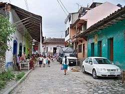
Street Figures in Coyutla, Mexico
References
- ↑ "Enciclopedia de los Municipios de México: Coyutla" (in Spanish). Gobierno Estatal. Retrieved 2009-06-08. External link in
|publisher=(help)
External links
- (in Spanish) Municipal Official webpage
- (in Spanish) [http://portal.veracruz.gob.mx/portal/page?_pageid=153,4493464&_dad=portal&_schema=PORTAL&municipio=coyutla.pdf Municipal Official Information]
This article is issued from
Wikipedia.
The text is licensed under Creative Commons - Attribution - Sharealike.
Additional terms may apply for the media files.