Jalcomulco
| Jalcomulco | |
|---|---|
| Municipality | |
|
Jalcomulco Location of Jalcomulco within Mexico | |
| Coordinates: 19°20′N 96°46′W / 19.333°N 96.767°W | |
| Country |
|
| State | Veracruz |
| Government | |
| • Municipal President | Primo Bonilla Morales |
| Area | |
| • Total | 58.4 km2 (22.5 sq mi) |
| Elevation | 1,417 m (4,649 ft) |
| Population | |
| • Total | 4,690 |
| • Density | 80.31/km2 (208.0/sq mi) |
| Time zone | UTC-6 (CST) |
| • Summer (DST) | UTC-5 (CDT) |
| Website | http://jalcomulco.egobierno.gob.mx/ |

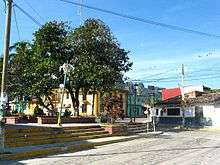
Jalcomulco is a municipality in Veracruz, Mexico, founded in 1825. It is located in central zone of the State of Veracruz, about 29 km (18 mi), from State Capital, Xalapa and 359 km (223 mi), from Mexico City. It has a surface of 58.40 km2.
The municipality of Jalcomulco is delimited to the north by Emiliano Zapata, to the east by Apazapan, to the south and south-west by Tlaltetela, and to the north-west by Coatepec.[1]
Name
Its name came from Nahuatl language. Xalkomolko: Xalli, sand; Komol, Casserole or hole; and ko, in. In the corner of the sand.
Pronounced in Spanish: Halkomulko.
Climate
The weather in Jalcomulco is warm all year with rain in summer and autumn.
Annual precipitation is 1,125 mm.
The average temperature is 24 °C, (75 °F).
Economy
In agriculture the region produces principally maize, coffee, sugarcane, and mango. It also produces cattle and poultry.
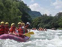
Since the early 1990s ecotourism has been an important part of the economy of the region, with more than a dozen hotels and professional dealers of adventure travel.
Main celebration
In Jalcomulco in May a celebration takes place to honor San Juan Bautista, Patron saint of the town.
Sports and activities
%2C_Jalcomulco.jpg)
One of the best whitewater rivers in all of Mexico, the Pescados Section of the Rio Antigua, flows through the town of Jalcomulco, and is commercially rafted.
Other activities to practice in town are rappelling, climbing, hiking, tyrolean crossing, mountain biking, landscape photography, and temazcal.
Filming location
Two thirds of the scenes of the movie Romancing the Stone (1984) were filmed in this area.
References
- ↑ "Enciclopedia de los Municipios de México: Jalcomulco" (in Spanish). Gobierno Estatal. Retrieved 2009-06-10.
External links
- (in Spanish) Municipal official webpage
- (in Spanish) Municipal official information