Castell'Azzara
| Castell'Azzara | ||
|---|---|---|
| Comune | ||
| Comune di Castell'Azzara | ||
 | ||
| ||
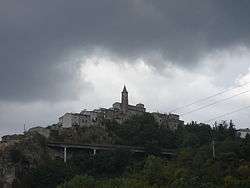
 Castell'Azzara Location of Castell'Azzara in Italy | ||
| Coordinates: 42°46′N 11°42′E / 42.767°N 11.700°ECoordinates: 42°46′N 11°42′E / 42.767°N 11.700°E | ||
| Country | Italy | |
| Region | Tuscany | |
| Province | Grosseto (GR) | |
| Frazioni | Selvena | |
| Government | ||
| • Mayor | Fosco Fortunati | |
| Area | ||
| • Total | 64.23 km2 (24.80 sq mi) | |
| Elevation | 815 m (2,674 ft) | |
| Population (30 June 2017)[1] | ||
| • Total | 1,438 | |
| • Density | 22/km2 (58/sq mi) | |
| Demonym(s) | Castellazzaresi | |
| Time zone | UTC+1 (CET) | |
| • Summer (DST) | UTC+2 (CEST) | |
| Postal code | 58034 | |
| Dialing code | 0564 | |
| Patron saint | St. Nicholas | |
| Saint day | December 6 | |
| Website | Official website | |
Castell'Azzara is a comune (municipality) in the Province of Grosseto in the Italian region Tuscany, located about 120 kilometres (75 mi) southeast of Florence and about 50 kilometres (31 mi) east of Grosseto.
It occupies the slopes of the Monte Amiata and was once important for the extraction of cinnabar. It was first under the Aldobrandeschi, and then part of the Sforza County of Santa Fiora until 1624.
Main sights
- Rocca Aldobrandesca (Castle). Of the original complex the palace and the watchtower remain.
- Church of San Nicola, with some Renaissance parts.
- Church of Madonna del Rosario, including a Renaissance chapel and frescoes in the apse.
- Villa Sforzesca, built by the Sforza in the late 16th century
Nearby, in the frazione of Selvena, are the ruins of Rocca Silvana, a fortress of the Aldobrandeschi.
References
External links
| Wikimedia Commons has media related to Castell'Azzara. |
- Official website
- Associazione Pro Loco Castell'Azzara
| Authority control |
|---|
This article is issued from
Wikipedia.
The text is licensed under Creative Commons - Attribution - Sharealike.
Additional terms may apply for the media files.