Caseyville, Kentucky
| Caseyville, Kentucky | |
|---|---|
| Unincorporated community | |
 Caseyville, Kentucky | |
| Coordinates: 37°32′16″N 88°03′51″W / 37.53778°N 88.06417°WCoordinates: 37°32′16″N 88°03′51″W / 37.53778°N 88.06417°W | |
| Country | United States |
| State | Kentucky |
| County | Union |
| Elevation | 367 ft (112 m) |
| Time zone | UTC-6 (Central (CST)) |
| • Summer (DST) | UTC-5 (CDT) |
| Area code(s) | 270 |
| GNIS feature ID | 489053[1] |
Caseyville is an unincorporated community in Union County, Kentucky, United States. Caseyville is located on the Ohio River and Kentucky Route 1508, 4.5 miles (7.2 km) west of Sturgis.[2]
During the Civil War, many of Caseyville's residents were Confederate sympathizers, and Confederate troops used the community as a base during skirmishes in October 1862. After the Confederates seized a Union steamboat, Union troops at Battery Rock entered into a standoff with the troops at Caseyville. The Confederates eventually left the town, and the Union Army entered the city; after temporarily arresting every male resident of the town and charging a fee for damages to the steamer, the army mandated that the town bar Confederate troops from entering.[3]
References
- ↑ "Caseyville". Geographic Names Information System. United States Geological Survey.
- ↑ State Primary Road System: Union County (PDF) (Map). Kentucky Transportation Cabinet. 2013. Retrieved January 19, 2014.
- ↑ Jacobsen, James E. (June 14, 1998). "National Register of Historic Places Registration Form: Battery Rock" (PDF). National Park Service. Retrieved January 19, 2014.
Municipalities and communities of Union County, Kentucky, United States | ||
|---|---|---|
| Cities | 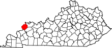 | |
| CDP | ||
| Unincoporated communities | ||