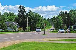
Caryville, Wisconsin
| Caryville, Wisconsin | |
|---|---|
| Unincorporated community | |
 | |
 Caryville  Caryville | |
| Coordinates: 44°45′05″N 91°40′28″W / 44.75139°N 91.67444°WCoordinates: 44°45′05″N 91°40′28″W / 44.75139°N 91.67444°W | |
| Country | United States |
| State | Wisconsin |
| County | Dunn |
| Town | Rock Creek |
| Elevation | 758 ft (231 m) |
| Time zone | UTC-6 (Central (CST)) |
| • Summer (DST) | UTC-5 (CDT) |
| Area code(s) | 715 & 534 |
| GNIS feature ID | 1562755[1] |
Caryville is an unincorporated community in the town of Rock Creek, in Dunn County, Wisconsin, United States.[1][2] The community is on the south shore of the Chippewa River, along State Highway 85, near where Dunn County Highway H crosses the river.
History
Founded in the mid-19th century, Caryville had a train station, post office, and Pony Express office by 1895.[3] Menzus R. Bump was designated postmaster of Caryville in 1882.[4] Caryville is popular with fans of paranormal activity, as area legends report that the community's Sand Hill Cemetery, the old Spring Brook School, and Spring Brook Lutheran Church are haunted.[5] 240th Avenue and the Meridean Slough are also reportedly haunted.
Recreation
Caryville is located along the Chippewa River State Trail, a bike trail on an abandoned line of the Milwaukee Road. The Caryville Savanna is a 420-acre (1.7 km2) natural area located on Brush Island in the Chippewa River, approximately 2 miles (3.2 km) west of Caryville (3 miles downriver).
References
- 1 2 "Caryville, Wisconsin". Geographic Names Information System. United States Geological Survey.
- ↑ Caryville, Wisconsin
- ↑ 1895 Atlas of Wisconsin
- ↑ "Capital Notes". Detroit Free Press. December 2, 1882. p. 2. Retrieved November 14, 2015 – via Newspapers.com.

- ↑ "The Truth Behind the Caryville Myths". WEAU, Oct 31, 2007. Accessed November 25, 2015.
External links
Municipalities and communities of Dunn County, Wisconsin, United States | ||
|---|---|---|
| City | 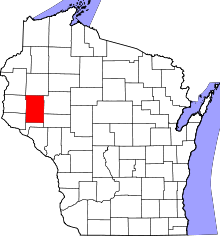 | |
| Villages | ||
| Towns | ||
| CDPs | ||
| Unincorporated communities | ||
| Ghost towns/neighborhoods | ||
| Footnote | ‡This populated place also has portions in an adjacent county or counties | |