Carrollton Historic District (Carrollton, Kentucky)
|
Carrollton Historic District | |
 | |
 | |
| Location | Roughly bounded by Main, Polk, 2nd, 7th, and both sides of Highland Ave. to 11th St., Carrollton, Kentucky |
|---|---|
| Coordinates | 38°40′45″N 85°10′40″W / 38.67917°N 85.17778°WCoordinates: 38°40′45″N 85°10′40″W / 38.67917°N 85.17778°W |
| Area | 92 acres (37 ha) |
| Architectural style | Late Victorian, Italianate |
| NRHP reference # | 82001553[1] |
| Added to NRHP | November 12, 1982 |
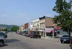
The Carrollton Historic District in Carrollton, Kentucky is a 92 acres (37 ha) historic district which was listed on the National Register of Historic Places in 1982. The listing included 334 contributing buildings. The district is roughly bounded by Main, Polk, 2nd, 7th, and both sides of Highland Ave. to 11th St. [1]
It includes the Carroll County Courthouse, designed by the McDonald Brothers of Louisville.[2]
References
- 1 2 National Park Service (2013-11-02). "National Register Information System". National Register of Historic Places. National Park Service.
- ↑ Jayne C. Henderson (August 1982). "National Register of Historic Places Inventory/Nomination: Carrollton Historic District". National Park Service. Retrieved May 24, 2018. With accompanying 69 photos
| Topics | |
|---|---|
| Lists by states |
|
| Lists by insular areas | |
| Lists by associated states | |
| Other areas | |
| |
This article is issued from
Wikipedia.
The text is licensed under Creative Commons - Attribution - Sharealike.
Additional terms may apply for the media files.